Heading south again, this time really south!
Getting ourselves into Mexico this winter proved a bit more of a struggle than we had intended. Paper problems at the border cost us an extra 2,000 miles and lost us a week (you really don’t want to know), but now we are well south of you…..wherever you are! As always, being flexible and politely responsive to what comes your way is better than blowing a gasket. We expect the possibility of much greater difficulties at other borders; we decided to consider the current adventure just good practice.
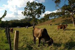
We had hoped to be in Mexico by December 12. The delays due to paperwork, however, brought us so close to the Christmas holidays that we decided to change our route. We had originally planned to go down Mexico’s east (Gulf) Coast. There is a lovely 25-mile stretch above Veracruz; we had dreams of collapsing on the beach under a palm tree, waiting for critical mass to urge us onward. But… this, along with every other stretch of beach in the entire country, was probably by now cheek to jowl with Mexicans enjoying the sand and palm trees for the holiday. So we stayed inland. We dropped due south from Brownsville, heading toward the Mexico City area. We traveled, forever it seemed, at sea level; the road was very close to the coast. It was hot and muggy and flat; there was lots of commercial farming, along with fields of goats with herders and un-herded cows and horses. Fishermen were selling dried shrimp in stands beside the road. Our first morning to awaken to the sound of roosters made us feel we were finally on our way.
Before too long the road started to climb over and around the mountains, and became much prettier, if slower. Trav’ler (the Tiger) passes trucks such as to be a good spokesman for Exxon gasoline (you remember, ‘Put a Tiger in your tank’), so the mountains are no problem for us; we like these roads. The trucks can be a big problem, however. They often are huge and in lousy shape. Each one comes with its “entourage” of folks trying to get past. And those are the cargo trucks. There are also zillions of local transport vehicles, often looking like they are on steroids, with bulging sides and stuff piled on top until you are amazed they can maneuver at all. It can be pretty wild, but fun too.
We crossed the Tropic of Cancer – a good sign. It was tropical sometimes, and the air would be smoky; a problem we would continue to encounter. They are burning the sugar cane fields. Now there are pineapples to buy from the stands, as well as tangerines and oranges. We slept that night in a lush tropical valley, with bougainvillea and palms everywhere, at 175 feet; it was 60 degrees when we awoke. The next day we climbed to 7500 feet, where we spent that night in an undeveloped national park (and woke up at 39 degrees). Everyone we saw was all bundled up; we were in heavy mist/fog. A note about Mexican national parks: they are very undeveloped. It appears that the government has belatedly realized the areas are worth preserving, so they have been set aside to keep the locals from cutting down all the wood and developing the countryside; but typically there are no facilities, no camping, not even roads mostly, and no rangers; just a section of land that is theoretically protected from future development.
Up and down and up and down. Beside the road, keeping the grass down, were goats and cows and horses and hogs and burros and chickens; we dodged and they scampered. Poinsettias in pots were for sale along the road.
Further south, the interior valleys were drier, with cactus and little water (and we were at 6000 feet). A river had been dammed, and that valley was green, with crops and irrigation lines. We saw we were following a water pipe; it appeared to us to be much too small to do any good, but apparently it was providing water to large towns downstream. Soon the area became increasingly industrialized; we were getting near the huge area that is greater Mexico City. We put ourselves down in Tepotzotlan, a town about 25 miles north of the city center, but all part of the greater Mexico City conglomerate.
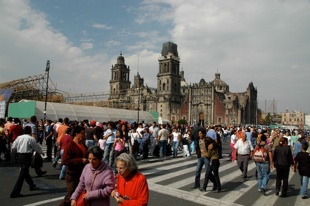
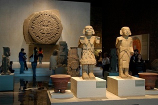
Aaah…..Mexico City and its environs. Now that’s a phenomenon all by itself. 36 million people. 40 miles across one narrow edge. Terrible air pollution, even on mild December days. We took the bus into town the day after Christmas. We arrived early enough that we really enjoyed wandering the streets; we greatly admired the old post office and the national museum (with a really cool Diego Rivera exhibit), both constructed as palaces a century or so ago. Then all the people came out of the woodwork and we were mobbed. The huge central square – the zocalo -- the second largest in the world (only Red Square in Moscow is bigger) was jammed. A huge skating rink and viewing stands had been erected, and the lines were miles long with people waiting their turn. Another huge structure, partly completed, filled most of the rest of the square. It was quite disappointing; Rick had never visited this spot before and the effect was totally lost. Another time. We also visited the National Museum of Anthropology, Mexico’s jewel museum, which has amazing things in it.
By the time we had finished all our touristing, we were wiped out. But we wanted to try the subway system to get back to the bus station. What an adventure! We changed trains four times, each one on a different underground subway level, all this during rush hour; but it worked very well, and we arrived at our destination without a hitch. Everyone was very helpful and cheerful. We felt proud. The bus back to our campground was deluxe, complete with a TV (unfortunately showing a very bad movie at a very high decibel level that was competing with the driver’s radio which was playing a Mexican version of “The Little Drummer Boy”… arrgh). We were glad to get home, at about 8:00 that night.
We stayed in Tepotzotlan a week. Our next destination would be Cuernevaca, roughly due south of Mexico City, and we wanted to drive straight through. Mexico City has such pollution problems, they try and curb it by not allowing vehicles on the roads on certain days. They use a system which links your vehicle license to certain days you can/cannot drive, and Thursday was our day to stay off the roads. So, between Christmas on Tuesday and no-drive on Thursday, we hung around a bit longer than we might have otherwise. We had been told that driving through the city on Sunday should not be a problem, and had instructions on how to do it. So that was what we were going to do.
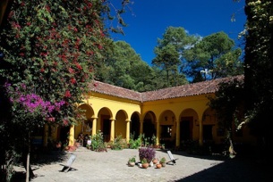
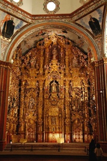
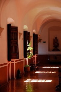
In the meantime we thoroughly enjoyed Tepotzotlan. We had been there once before, and knew there was a gorgeous museum in town; it’s still there, and still wondrous. It was built as a monastery between roughly 1600-1750, and its simple graceful lines really appeal to us. We spent one entire morning there, taking pictures and enjoying the setting. And… there is an ice cream seller in the square that makes the most exquisite mango ice. The square itself as well as many of the roads in and around it have been redone in the nearly five years since we were here last. The result is one of the more lovely town plazas we have seen in Mexico; different levels with differing types of stone work, bougainvillea and other flowering shrubs everywhere. It was a great visit. We were entertained every day and night by firecrackers and music as the holidays were celebrated in style. Lots of parties and activity in the central square.
So… Sunday came. And Rick, wonder that he is, drove through Mexico City like a pro. This man is incredible. As noted, it’s about 40 miles until you pop out at the other side. We stopped to do some grocery shopping before we left Topotzotlan, and then headed out at about 10:00. Got through with no problems; very quiet and pretty straightforward. Took the turn to Cuernevaca and climbed to 9,600 feet on a lovely curving road through trees and forests; a favorite road for the sport bikers of the city and they passed us in clumps. A few miles later, Kathy says quietly, “I’ve lost my notebook with ALL my stuff in it, including our tourist visas.” We stopped and tore the coach apart. Then… back we went, by now 50 miles, to the grocery store. Yes, back across Mexico City, by now not such a quiet and easy ride. We got lost at one point and were driving on the downtown streets with the crazy cab drivers, honking cars, etc. etc. But Rick never blinked an eye, found the road we wanted again, and kept us pointed north. We got to the store, had someone help us translate “black notebook” for the lost and found people, they smiled and handed us back the notebook and we collapsed at a Burger King (yes!) for a gringo lunch. It is now 2:00.
Then, for the 3rd time, we traversed Mexico City. Ever increasing amounts of traffic; the route, at least, was familiar to us by now. We made no mistakes, took the turn to Cuernevaca, chose the toll road this time instead of the free road we had taken on our first sallying forth, climbed over the mountains out of the bowl Mexico City inhabits – to an ultimate height of 9,973 feet – and dropped down into the Cuernevaca area. We finally arrived at our campground at about 5:00; the trip, which should have taken us about 2 hours total has occupied an entire exhausting day. Rick was a hero for going back, and Kathy vowed never, ever to take her black notebook out of the coach again, regardless of how good the reason might be!
We had, however, found a lovely spot for ourselves. Campgrounds in Mexico range from super-deluxe to do-it-yourself bare dirt. This one, with sites spread out under the trees, is owned by a couple who spent many years in the states, in Detroit where he was an auto engineer. Needless to say, the sites are laid out in very straight lines. We stayed a few days while we recuperated from our Mexico City turmoil; this had us in the park over New Year’s Eve, which was enjoyed by everyone in the park by means of a bonfire and drinks provided by our hosts. We made several new friends, particularly a young couple with a small child. She seems driven to success, and runs her own business; we watched her run every morning, in a very dedicated manner. She was a delight, and had insights into how it all “works” in her country.
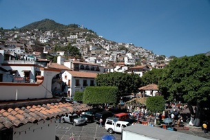
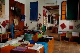
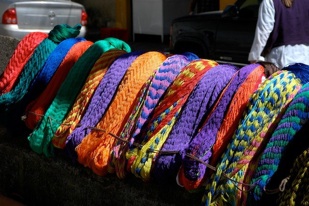
Cuernevaca is a day-trip away from Taxco; after visiting we have called it our first “new delight” in Mexico. Taxco is an old silver mining city, back to the Spanish conquest; it’s laid out on a VERY steep hill. No one drives in town; everyone takes these little VW bug taxis that go zipping around the corners and head straight up enormous inclines. Some corners are so tight even they have to do a 3-point turn. We saw several batches of Girl Scouts and Girl Guides from various countries; we figured they were probably in town for the day from Mexico City where they were having a convention. Taxco is where you go for silver jewelry; we had been warned it would be expensive, but found this simply wasn’t true. Yours truly bagged two new pairs of earrings, both exquisite and marked with the prerequisite 925 (indicating purity) and garnering admiring comments ever since. We had a delightful day.
We were a bit disappointed in the time we spent in Cuernevaca. Or at least Kathy was. This was a case of not being able to get things to jibe. The central plaza was dirty and crowded and not very interesting. There was a formal garden we wandered in for a couple of hours that was interesting, but that was the best of it. We passed on seeing a couple of recommended sites because we wanted to see an American movie that sounded good. Actually, it was quite horrid, despite the presence of Juliette Binoche and Forrest Whitaker, two of our favorites. But the cab ride through interesting neighborhoods back to where we had left Trav’ler was really cool, and we realized we needed to come back and give the city another chance.
But on to Oaxaca, one of our favorites. We made our way to the little campground on the hill above the city, and upon entering discovered some friends we’d made last year. They have just returned from Honduras, Guatemala and El Salvador, and had great info to share. We made other new friends as well. This campground, it seems to us, is a sort of clearing house for folks heading to and from Central America. Unfortunately, we got the creeping crud shortly after arrival, and spent most of a week in recovery. By the time we were well enough to do some sightseeing (we had planned a day in Oaxaca re-visiting favorite spots), we felt pressed for time and went on. We did stop at the same rug factory in Teotitlan where we’d had such good luck last year, and bought just-one-more, a little rug for just inside the door.
Heading southeast from Oaxaca, we traveled on this great, windy road heading toward Chiapas. Going down the mountain, a huge truck heading up was hauling two wire cages, one with a lion, the other a tiger, inside. That was really something to have coming around the corner at you! We assumed they were being transported to a zoo. By the time we got all the way to the bottom of the mountain we had dropped from 5000 ft to 500 ft. We spent the night beside a little palapa along the road; the family welcomed us and wouldn’t accept any money; we bought a few things to try and repay them for their hospitality.
At 20 feet, we were at the edge of the isthmus that divides the Gulf Coast from the Pacific Ocean. We were able to cross with no problems, although we’d heard horror stories of folks blown completely off the road by the winds in the area (you go through the town of La Venta, which might tell you something!). There are wind farms in this area; the machines were quiet as we tiptoed past. It was 94 degrees at 10:00 am; different weather, that’s for sure. After crossing, we climbed again, through the Sierra Madre de Chiapas, towards Tuxtla Guttierez and then, at 7000 feet, San Cristobal de la Casas. This is very mountainous country with the winding road going first up, then down, then up again. As we drove we would either pass or be passed by huge double trailer trucks traversing the mountains like bicycles; struggling slowly up the climbs, then whizzing down the other side enjoying the wind in their faces. We’d climb for awhile, then cross a plain, then climb some more. This went on for quite awhile. There were cornstalks in the fields, and cattle. It was increasingly greener, a delight after all the time in the interior, which is very dry and brown this time of the year. Tuxtla Guttierez, the capital of Chiapas, is a mostly modern city; very clean and prosperous. As we climbed toward San Cristobal, and passed through some of the indigenous villages for which the area is famous, there was much more trash, less evidence of local pride, and we received many suspicious glances. The women were in traditional dress, very colorful, but we had been warned not to try and take pictures of them.
We felt a little unwelcome, and this feeling would come back to us occasionally during our visit to this area. San Cristobal is a justifiably famous city, with a proud heritage, lovely churches, and handicrafts in great profusion. It is a UNESCO World Heritage Site, and very well maintained. It reminded us of our beloved Patzcuaro, along with San Miguel de Allende and other colonial towns. We felt comfortable in the city, although we took no pictures of people, and at one point a young mother stared very hard at me. She was holding her baby, and I’m sure felt that was what I was staring at in return, but she was wrong: I was very interested in what she was wearing. Ah, well. Everyone can’t be happy to have us around.
One odd adventure: we were invited to go on the air at the local radio station. We were approached in our campground by a fellow who apparently runs the station. It’s kind of like Radio Free Berkeley. He does a lot of fussing at the government about things that need to be done, and was interested in having us talk about our impressions of San Cristobal – not being complimentary, but to talk about all the traffic and roads that need to be fixed, etc. We played along a bit for him, at least until he asked us – on the air, mind you! – how much of a donation to the cause we would be comfortable giving. At that point we started to back-pedal. But it was quite an experience. With our radio backgrounds, we were able to appreciate the one-man-show he was trying to accomplish; he was doing all the production elements himself, with only his wife standing by to help fill in. His wife! Now she was a treat! By the pictures on the wall, she was a former exotic dancer, now older but still racy and still trying to dress the part. Good thing I’d left my camera behind! Wouldn’t have been able to resist!
But it was time to go start getting “ruined.” Off to Palenque, the start of our Yucatan adventures. As we climbed to the highest pass of the day (7983 feet) and then headed down out of the mountains, to the northern part of the state of Chiapas, we discussed how we felt about our time here. As you may know, Chiapas is a very poor section of Mexico, suffered through a period of nasty suppression by the government in the 1990s, has a very proud and private heritage, and doesn’t suffer tourists with much pleasure. We found it to be an area of real contrasts. This is the area where the Mayans lived before the arrival of the conquistadors. The indigenous population has kept remarkably separate from the newcomers for nearly 500 years, preserving the old ways and remaining protective and suspicious of others to this day. They try hard to maintain their traditions, but time is rapidly catching up with them. We saw small children heading off to school with Disney backpacks; teenage girls standing and chatting – some in traditional dress and some in skimpy tee-shirts and low-slung jeans. Women in traditional dress shopping at the supermarket. Their farms were typically very neat and tidy, and looked prosperous; work was being done with oxen instead of tractors. Then in another area there would be modern dairy farms. And then there were the strident Zapatista signs. An area in transition.
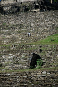
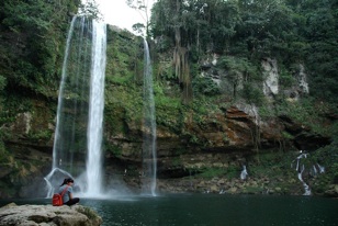
Dropping out of the mountains we entered lovely forests; the cleared areas had cornfields climbing up the very steep slopes. We stopped to visit the ruins at Tonina, a small site that we found quite interesting. Kathy hiked to the top of each and every building; Rick took great pictures of her from below. A fellow visitor called her Indiana Jones; she felt proud. The next day she could hardly walk. What else is new? We spent the night in a quiet field next to the ruins, and woke up to the caretakers’ free-range chickens happily ranging freely and telling us all about it. Also peacocks, horses, cows, you name it. This is a beautiful, lush area, with very productive soil in the grassy fields between the stands of trees. An area to spend more time in; we were treated with friendly courtesy and enjoyed ourselves. When we left, we headed further down the hills; now we were seeing people drying coffee beans in their driveways beside the road and now the corn in the fields was ripe, and for sale in stands. We stopped at the lovely Misol-Ha cascada (waterfall). The 20-somethings were all swimming in the pool at the bottom; the rest of us were content to take pictures of this 25-meter high fall in a great jungle setting.
All the plastic containers in the coach are having fits – up the hills, down the hills, can’t you make up your minds. Every time you release the tight lid on one, the contents take a deep breath. It’s a wonder nothing has exploded!
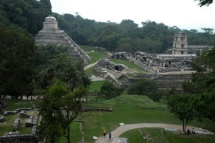
And then to Palenque, at 200 feet home to one of Mexico’s most famous Mayan ruins. Now we’re in the jungle, in what’s purported to be the rainiest spot in Mexico. And it did, in buckets – for almost 14 hours straight. We had a chance to see if the latest repair to Trav’ler’s leaky seam would hold (YES! Maybe the problem has been solved!) Our campground was a-swim, but everyone seemed quite prepared to cope, even the German couple on their motorcycles, who took a room for the night. The howler monkeys in the trees seemed to enjoy the rain as well and performed loudly as advertised. Palenque is cool, no doubt about it (although very hot and muggy). We wandered around the site for several hours, enjoying great vistas from the tops of structures (Rick even did some climbing here) and imagining what things must have looked like 1000 years ago.
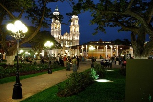
But onward, ever onward. We have decided murky heat isn’t our favorite setting, and we’d had a ton of it at Palenque. So we headed toward the Yucatan Peninsula and Campeche, right on the coast. And discovered a new favorite city. Campeche is an old port town, and the city’s growth has been inland from the old colonial center right on the water. And, lucky-lucky-lucky, the visitor’s center is right between the water and the old part of town… and it’s okay to spend the night in their parking lot. So we did, for two nights. This gave us a chance to see the old town at night, which is absolutely magical. Campeche’s city fathers decided some time back that “If you fix it up really neat, they will come”; so the old town area is neat and clean and lovely. Then they decided it would be neat to light the old part of town at night, and they did a spectacular job of it. Wandering around after dark is a real treat; we enjoyed ourselves very much. Then during the day we took a charming trolley-car tour of the city, followed by trekking back to see more of places that had intrigued us. We enjoyed this city like we have few others. I finally solved one confusion by investigating for myself: the tour guide kept pointing at an old church and saying what I thought was “black rice.” Turned out there was a black crucifixion scene made out of ebony (“Black Christ”); guess I need to have my ears checked…
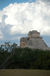
We reluctantly left Campeche for more ruins, visiting a small site at Sayil before heading for Uxmal, another one of the biggies out here. And at Uxmal we started rethinking our position. It’s hot, we said; REALLY hot; and humid, REALLY humid. And we are getting more and more into the touristy area of Yucatan, complete with “The Swarms”, our code word for the dreaded Tour Buses; and an RV caravan with folks talking about knocking off three ruins sites today. With Chichen Itza, Tulum, Playa del Carmen, etc. etc. still ahead of us, do we really want to do this? We like the ruins; each is different; Kathy particularly likes the jungle settings. And she was eye-ing one you get to by taking a boat upriver in the jungle to a very remote spot. But all this was beginning to sound very draining. The refrigerator is working waaaay overtime, even on its coldest setting – we are losing milk in about 4 days, and fruit is rotting almost as fast. Most importantly, we asked ourselves our foundational question, are we having fun? In a word… no.
So, okay, let’s go up to Merida at least. Supposed to be a stunningly lovely city. And there’s some shopping we want to do there. Our Costco card is about to expire, and we won’t be renewing it because there just ain’t no Costcos in Central America. And… we needed to buy a “bomba.” No, not planning to blow up any buildings. A bomba is a pump. They come in lots of sizes; we needed a small one to help us take on water faster, to be found at Home Depot!
So, we went on up to Merida, with shopping list in hand, and guide book to show us around this great Spanish city. And suddenly it all went south. Won’t share the gory details but… Costco card had already expired; credit card had been shut down on us; we got hit by some fool drunk in a parking lot (all the damage to his car as he sideswiped the corner of our aluminum storage boxes on the back of the coach - they are tough. If we hadn’t been somewhat shaken we might have laughed as he picked up his gas door and stood there trying to fit it back in the hole where it came from); we couldn’t find Wal-Mart, which had the pills we wanted to pick up; and… and… Rick made an illegal turn and the cop was there so fast it made my head spin.
Knowing a thing or two about Karma, we did a quick discretion/valor comparison and snuck out of town. (We did manage to talk our way out of the ticket, incidentally.) All of a sudden we weren’t having a good time and so we bailed. We headed for the hills, literally. We went due south, out of the Yucatan, heading for Guatemala and higher, much higher ground. We found a gorgeous resort campground south of Campeche, right on the water, where we took three days of attitude adjustment, a very smart move. (Our receipt for payment of campground fees said we were paying for a “carro gringo”!) On the grounds were a lovely clear swimming pool, views of a pretty beach with palm trees, and best of all: constant cooling breezes from the ocean. By the time we left we were feeling much better about ourselves and our plans.
We reached the border uneventfully, except for a nightmare trip into a medium-sized town that we made by mistake while looking for a ring road that would take us around. Intrepid Rick forges ahead; Kathy mutters about asking for help. Finally asked and got lousy information; forged onward. After several hair-raising turns and backing-and-filling while trying to finesse the squeaky little streets of town (Comitan), a lovely lady said the boulevard was two blocks straight ahead, which earned her a big hug; we sighed in relief and exploded out the other side of town just as quickly as possible.
As we neared the border we found ourselves in a lovely valley at just under 2,000 feet with the high mountains of Guatemala looming ahead of us promising almost immediate relief from any lingering lowland temperature issues. We settled for the night in a Pemex station near the border. It was very busy the next morning with trucks coming in from the Guatemalan side to fill huge drums with gasoline that was cheaper in Mexico. They seemed to think they had all day/night to do this and that it was a day off from their regular jobs. We also wanted to fill our tanks and didn’t want to take all day. So… Kathy, of course, thinks she can organize these folks into a more efficient use of the available pumps. All these guys… just stood (or sat) there grinning at me. What did they care if it took all day! Finally we got someone to make a space for us, filled up, and trekked on to the border.
We had an easy crossing into Guatemala. La Mesilla is a quiet little town and very straightforward. Would that we could count on all the crossings to be so simple. The fellow who helped us get parked then went inside and helped Rick fill out papers. We were gone in about 30 minutes. Goodbye Pesos, Hello Quetzals, and on to new adventures. Higher up adventures, definitely. We’ve always known our limitations, heat-wise. Both of us grew up in sunny-but-cool California; we don’t do humid heat very well; we like mountains much more than beaches. We have no air conditioning in the coach, on purpose, but right now we sure wish we did. So we have a new motto: “Keep on Climbing… it’s Cooler up There.” And immediate success: we spent the next night at over 8000 feet, happily huddled under our extra blanket and awakening to 39 degrees the following morning.
All this aside, we really are having a wonderful time. We keep meeting great folks who are doing great things, and the countryside continues to enchant us. We know Guatemala will be more of the same. Wish you could be here with us.
Continuing our adventure, Rick and Kathy