January 2009
Finisterre, Land’s End, El Fin del Mundo
A quick trip to Chile and then Patagonia Part 1
Tierra del Fuego: This is the home of Cape Horn and Ushuaia, the southernmost city in the world, and the end of our southbound road. Eighteen months after leaving Prudhoe Bay at the top of Alaska’s Dalton Highway, we’ve gotten as far south as one can drive anywhere in the world. While certainly not the end of our Panamerican adventure, it is the turn-around point. From now on we’ll be heading north.
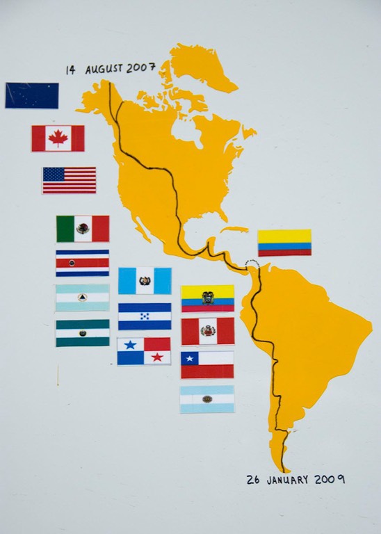
Here’s another one for you: Australopithicus nomadicus. Guess what? That’s US!!! Who knew we would become so exotic as to have Latin names? (compliments of our good friend Mabelle Lernoud) “Austral” is a word that refers to “south,” in this case the southern hemisphere; while “nomad”… well, guess there’s no surprise there. We like the phrase, but you can still call us Rick & Kathy if you like. Oh, the picture to the right is of the map on the side of La Tortuga. It pretty much tells the tale.
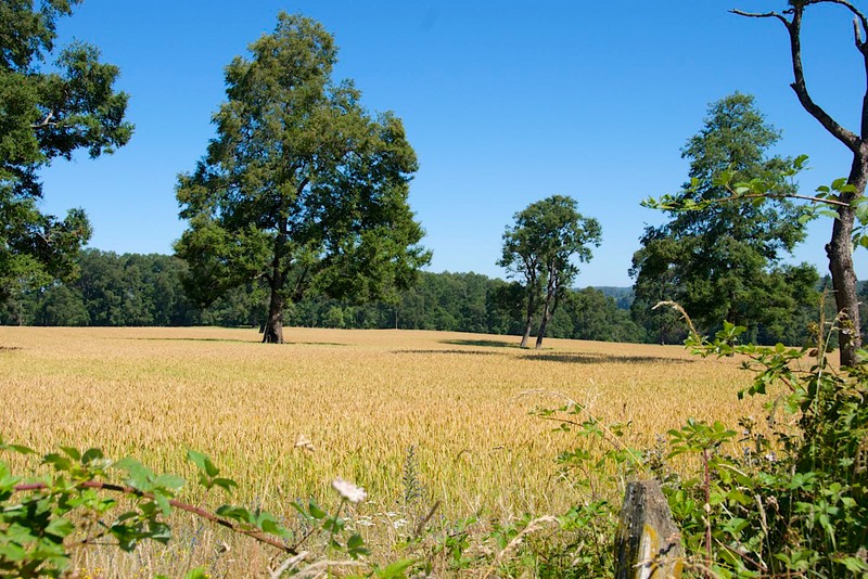
But to go back a few weeks. We went into Chile, got new cameras and a new inverter and came back to Argentina. That’s all she wrote. But that, of course, isn’t really fair. In Chile, we spent far too much time going up and down the Panamerican highway, but we did see some very pretty country. Chile, once you get south of the northwestern desert area, is lovely. Very green, plenty of forests, and tremendous agriculture; John Deere and Massey-Ferguson are alive and well down here. The area is called the Chilean Heartland, and with good reason; it could also be called the Land of Bountiful Harvests. You know all that fruit you’re eating right now? Much of it comes from Chile, no doubt.
It’s July here; there are still fresh cherries, but also watermelons by the semi-truck load, and the peaches are ripe – incredible peaches. We’ve been eating them by the truckload, too. And plums, and….well, you know; it’s all the stuff you’re buying in the market right now. (And I can buy a dozen dead- ripe, white peaches – with no bruises -- for a buck and a half.) But I digress (and gloating isn’t nice, Mom said). One unhappy sidelight about the fruit in Chile, though; this time of year, you cannot find a decent apple to save your soul; the home-grown crop is months old and the country doesn’t import any produce; bummer. All this while you are enjoying the fall crop in the United States; your turn to gloat.
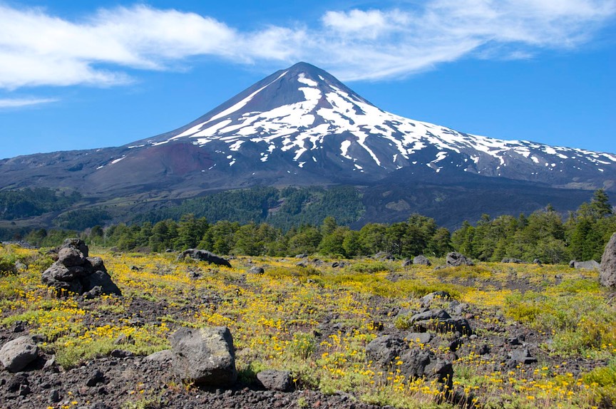
When we finished our business in Chile, we wanted to get back into Argentina, but didn’t want to completely retrace our steps (oh, no, not Osorno again!). So we drove east off the Chilean flatlands into the mountains and NP Conguillío; this park protects the area around Volcan Llaimo, Chile’s second most active volcano. (We saw a sign pointing to an extensive lava flow from January 2008; that’s plenty active for us.) This is a surprisingly lovely park. There is plenty of area that’s simply volcanic and very barren, but it doesn’t take long for the plants to take hold; there are lots of trees, and at this time of year the wildflowers are rampant. We very much enjoyed our drive through this park, and spent a couple of days in a pretty little glade near a brook. It was a very nice spot to recuperate from all those days on the Panam.
Emerging from the park, we headed for the border through this very rural part of Chile, and had a simple, straightforward, easy border crossing above the small town of Icalma. No agricultural inspection; muy bueno! This crossing put us back along the edge of Laguna Aluminé, which we had visited a few weeks earlier. It also directed us down through Junin and Bariloche and El Bolsón again. We did skip going through lovely San Martín de los Andes, by taking an alternate route further east; this took us through some much more barren countryside, reminding us of eastern Washington State, but it followed a lovely river and went through some very nice rock formations; not all bad. Beautiful country, but this time we merely passed through; we were very anxious to resume our journey down to the bottom of South America.
You won’t be surprised to hear we gave Bariloche a bit of a wide berth; but we wanted to spend more time in El Bolsón, so we stopped there. Sadly, the lovely and charming town we had enjoyed so much in December was now jammed full of backpackers and their guitars and piles of litter; the kids are great, don’t misunderstand me; but after our recent experience we’re really into avoiding crowds, so we just went on. Such a gorgeous area, right on the eastern edge of the Andes; but we really recommend visiting other than in January and February. Staying in the mountains, we moved south as far as Esquel (which was a town we really liked), then plunged eastward, across the pampas toward the Atlantic Ocean.
And really, really entered what we are calling Patagonia – at last! Patagonia means lots of different things to people, and covers different parts of southern Chile and southern Argentina, depending on, well, different things. We have decided that for us, the real Patagonia began when we left the Argentine Lake District.
Receiving good advice, we had picked a road (Rte. 25) across that we can heartily recommend. It crosses Argentina through an area variously referred to as “badlands” or “like Bryce Canyon” and it was quite interesting. We followed the Chubut River for much of the way, and it was a good choice. An extra bonus: since we were traveling from west to east, we had a strong tail wind the whole way, and got the best mileage we’ve ever seen from La Tortuga – just a smidge under 20 mpg. A side benefit of the traditionally fierce Patagonian winds.
Reaching the Atlantic at Trelew, we checked out the paleontology museum there (small but quite nice, with some incredibly complete skeletons). We chose not to go north to Puerto Madryn and the Valdez Peninsula, huge tourist areas that are very crowded right now; maybe at a quieter time of the year. Then we began the plunge down toward the bottom of the hill. Route 3 is the main road, but for starters we decided to take a parallel road (Route 1) that turned out to be good gravel, very light on traffic, and would take us to the Punta Tombo Provincial Reserve and – pinguinos.
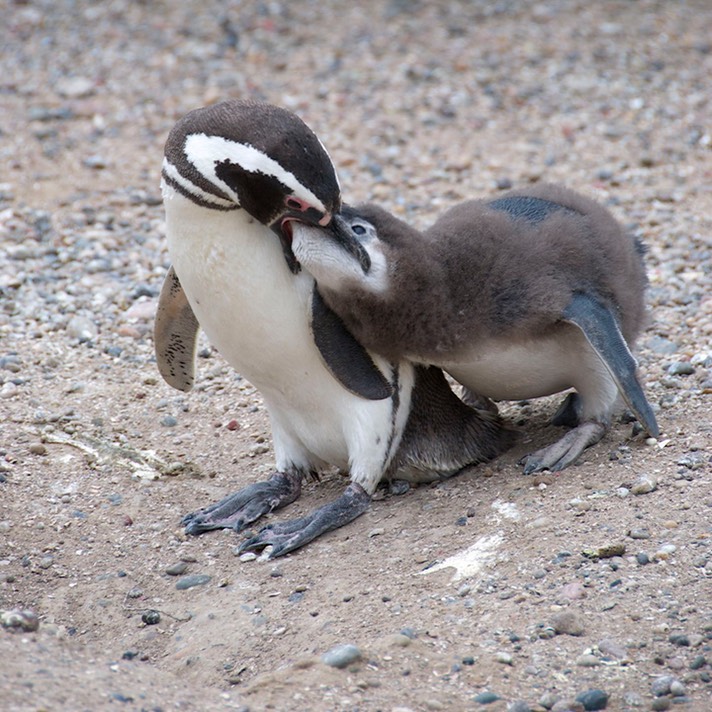
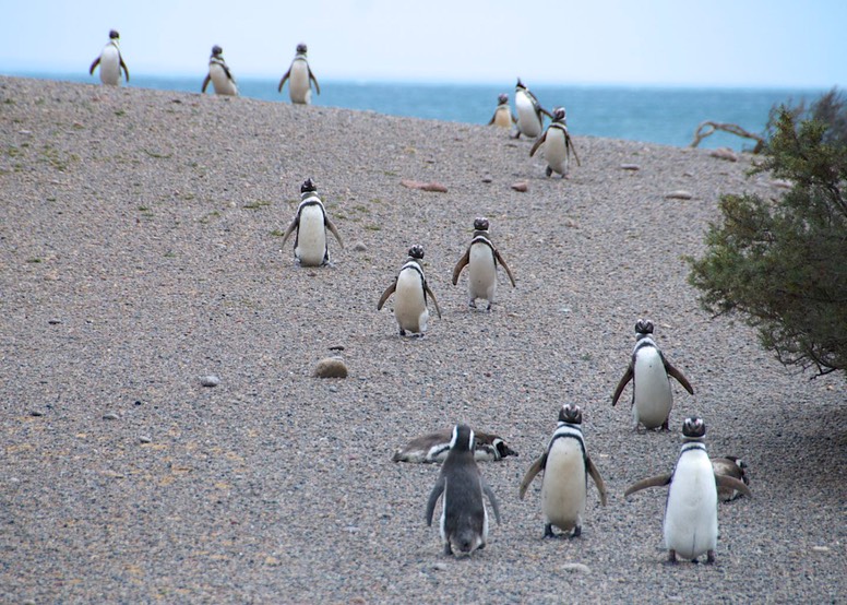
The Magellanic penguins have their largest nesting colony at Punta Tombo, and it’s quite a sight. There are other places to see them, and we will continue to enjoy them as we can, but this place is quite amazing. The birds are adorable; in gay profusion; and definitely in charge. There are signs reminding you that they have the right of way, telling you to keep your distance, all that good stuff; but no one has told the penguins. They cross your path, stop and look up at you, poke you in the leg out of curiosity, and let you watch them to your heart’s content. There were loads of chicks in various stages of development, all complaining about how long it was taking for lunch to be served. It was way cool. There is a large herd of guanacos there as well, co-existing in harmony with the birds; I wonder if they keep stepping on each other? We have tons of really cute penguin pictures on the photo page. We had a good time, and had the bonus of meeting a delightful fellow (Casper), an überlander from Holland, in the parking lot. We chatted, and since we are all heading in the same direction, promised to meet up again, which we did.
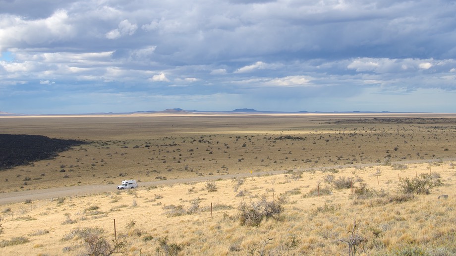
Moving south, we spent the first of several days traveling down the isolated Atlantic coastline, sometimes within sight of the ocean, but with land that was always becoming increasingly barren. We are not finding it unpleasant , the evaluation of other travelers; it is somewhat similar to the barren areas in the far north of Alaska and the Northwest Territories. We like the distant view, the scrubby but rugged plants, and the occasional views of rheas, guanacos, wild hares and other critters in the distance. We spent the night on a bluff overlooking a quiet bay; charming views and strong breezes. One advantage of our route however was that we missed a lot more of this countryside to the north. Many European überlanders ship their vehicles to Buenos Aires and head south from there. Route 3 runs for more than 3,000 kilometers from BA down to Ushuaia, most of it pampas; we joined the route at about km 1750, a point where travelers doing the entire road are already complaining about the lack of variety in the scenery.
We are coming into increasingly isolated areas. There are basically two major towns on the coast from here to the bottom: Comodoro Rivadavia and Rio Gallegos. We stopped in Comodoro to shop, then camped for a few days at Rada Tilly (these names!), a small resort town shortly south of there. The campground had shelter from the very strong (and hot) winds, but not from the dirt and sand. But we really appreciated the chance to rest for a bit. While there we got really lucky, and our good buddies Yasha and Jürgen caught up with us. We had followed them south from Guatemala, finally catching them in southern Ecuador (you may remember); then they had taken a different path across Argentina to Brasil, Paraguay and Uruguay before diving southward to Ushuaia. We had despaired of ever being in the same town as them. But they found us in Rada Tilly and we had a lovely reunion. And as we were coming into town, Casper rode up on his bicycle; also, a French family showed up that knew Casper; so we had a lively time of it in Rada Tilly. When we were finally moving on we checked a local newspaper; it had gotten up to an unseasonal 93 degrees (34 centigrade) and the locals were complaining; no wonder we were in a world of hurt.
A different part of the world: tire shops are now gomerias (quick: what were they called before? Vulcanizadoras, or llanterias. Good job!) Does this mean that tires (which used to be llantas and then became nuematicos) are now gomers? Inquiring minds… nah!
An isolated and barren countryside this is. As we drive along, leaning into the wind (only figuratively for us, but you should see the bikers) and watching the dust clouds billow around cars whenever we are on an unpaved road, we amuse ourselves with technical discussions of the difference between dust and dirt. You should feel free to participate; we welcome analysis from all quarters.
Past 45 degrees south; we are halfway to the South Pole. Then 46 degrees; they are coming quickly now, since we are pretty much shooting straight south. Scurrying sheep and estancias are increasingly common, along with guanacos.
We stop for fuel and water at a YPF station (they are huge and frequent); there is a water faucet and Rick gets the tank mostly filled before he realizes that it’s hot water and the sign says it’s for travelers’ mate jugs. Talk about conveniences!
We are seeing the occasional oilrig and are reminded that the most recent developments along this coastline were after oil was discovered. Comodoro Rivadavia, Caleta Olivia, Rio Gallegos, all big oil towns. All the towns use the same street names; all the houses have huge satellite dishes (DirecTV). Pickup trucks rule.
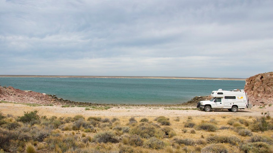
A welcome change from the similarity of the scenery was a stop at Reserva Provincial Ría Deseado, near Puerto Deseado. This is an estuary teeming with wildlife. You can take boat tours up the river and to outlying islands. We contented ourselves with a leisurely drive back up the riverbed, a night on a bluff overlooking a very pretty spot (and a gorgeous sunset), and poking around in some of the coves at low tide. It was an intriguing area. We even spotted, although at such a distance we wouldn’t be willing to swear on our grandmother’s bloomers, what we think were some rock hopper penguins. The night was quite warm and brutally windy, but we survived.
On southward – more frequent rhea sightings (these are the guys that look a lot like ostriches); they have a slew of chicks scurrying behind and are rather clueless about how to get out of your way! We spend a lovely, quiet night out of the wind on a beach (beneath a bluff) north of the town of Puerto San Julián. Then the next day we stopped in town for a bit, and liked what we saw. It’s a nice and tidy little town of about 6,000 happy folks looking to have you stay a few days on your way north or south.
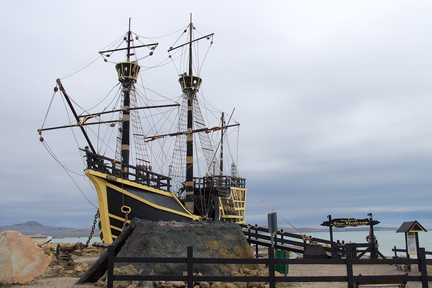
Puerto San Julián is where Magellan landed in 1520 and spent the winter. There is a replica of his ship; what a dinky little thing that was! Not surprising his crew was unruly. The replica is in a nice location next to the water; not far away is a fighter jet from the Malvinas War of 1982. You know this as the war between Argentina and Britain over the Falkland Islands. The Argentines call them the Islas Malvinas and still claim ownership. You may remember that the British whomped on the Argentines; the islands are still in dispute, however. Living history. In any case, there were nice plaques commemorating those who fought. We thought there was a nice juxtaposition between the two sites. A little later on, shortly after entering Tierra del Fuego, we would see a sign: Las Malvinas Son Argentinas. These folks really mean it!
Crossing the 49th parallel (the Canadian border up north) – and then the 50th. More sheep and rheas and guanacos. Next stop was meant to be a visit to the national park at Monte León, newest on the Argentine coast. It’s a wildlife bonanza, we had been told, and also has some very interesting rock structures. But… we arrived at the turnoff in driving rain and temperatures of 40 degrees; it required 20 kms in on a gravel (muddy) road; we decided to pass and go on. The days were catching up with us, too; we now had less than a week to get to Ushuaia, and considerable miles yet to cover. Next time.
51st parallel – the landscape is changing some; more color in the pampas, more grasses and wildflowers, and even a couple of flamingos in a small pond area. Camped the night along the Rio Gallegos, just west of the town of the same name.
52nd parallel – almost at the Chilean border. Why are you going to Chile now, you say; you are headed for Ushuaia, which is in Argentina. Well, here’s the deal. Tierra del Fuego is the bottom of the hill, the long-time-now goal of this journey. But Tierra del Fuego is actually an island (well okay; the purists will say it is actually an archipelago; you win). Part of Tierra del Fuego belongs to Chile and part to Argentina; Ushuaia is in Argentina. And…Argentina doesn’t have a land connection to its lower parts. So, you cross into Chile, drive to where you catch the ferry, drive across Chilean TdelF, cross back into Argentina, and drive down to Ushuaia – “the southernmost town in the world.” Now, ya got all that? Pain in the rump. You know how we love border crossings.
Just to keep you up to date, we had an easy time of it at these border crossings. Back into Chile always gives me the willies, but the inspector was kind and gentle with me. I gave her a carrot offering, and then in poking around in the fridge she found some quartered apples I’d forgotten. I thought she’d snatch them right up, but she only wanted me to core them. This seemed amazingly logical to us, as the seeds could cause problems later on; why don’t other BBs behave so well? And the ferry ride was fun. It takes about 15 minutes, and you have to be careful getting on and off, but we had no problems. We’ll see what happens when we return; we will take this same ferry boat when we leave TdelF. The entire process of leaving Argentina, entering Chile, taking the ferry, leaving Chile, and entering Argentina again took us seven hours, including a stop for lunch. It was 85 miles.
Once back on track, we were picking up steam, getting closer to the end. And, miraculously, the countryside soon became more interesting. First we saw scrubby trees and more color in the grasses along the roadside. The land began to look more fertile and less barren. We saw fewer sheep and more cattle and horses (even with some gaucho riders). These were big, sturdy horses. And then the mountains began to peek over the flatlands.
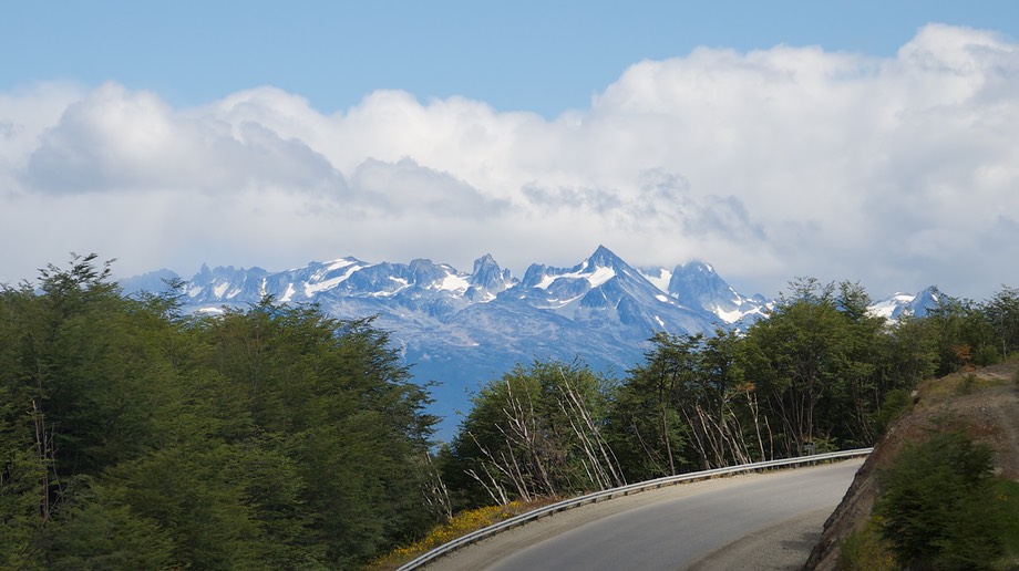
Everyone says “you’ll love Tierra del Fuego; it’s beautiful” but you know how people talk. But wow! Once into the mountains, it started to look like northwestern Canada. We climbed up over Paso Garibaldi (at 1350 feet possibly the lowest pass in the Andes). There was standing water in boggy areas, and downed trees; we caught ourselves looking for moose! What a delight. For those of you who are asking, there are no moose here; the largest animals on Tierra del Fuego are foxes.
We passed through the funky but cute little town of Tolhuin, which has the most incredible bakery within at least a thousand miles, Panaderia La Unión (thank you, Syd and Sharon, for making sure we didn’t miss this treat). Tolhuin is on the edge of lovely, long Lago Fagnano (also called Kami), the first large body of water we had seen (other than the South Atlantic itself) since leaving the Bariloche area. Surrounded by trees and mountains, it was a welcome sight.
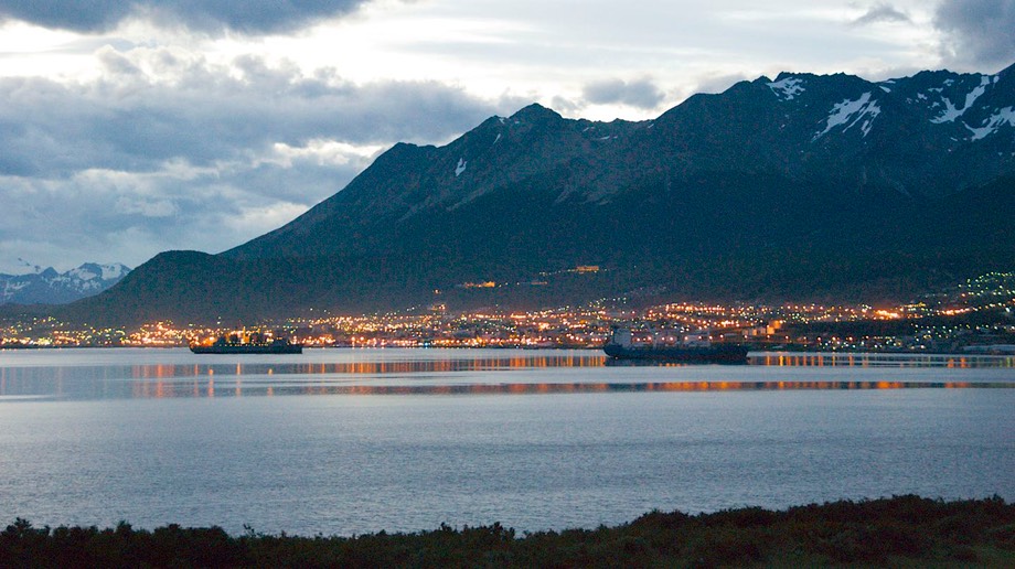
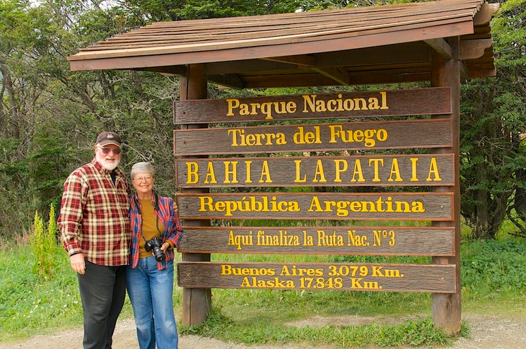
Knowing that you start back north along this same road, and anxious to get to Ushuaia, we didn’t linger long, and arrived in Ushuaia an hour or so later. The end of the road. The southernmost city in the world. Our goal for the last 18 months. We were here.
And here we are staying for a few days, before heading north once more. Ushuaia itself is a nice but unexceptional port town; it caters to the cruise ships too much, but still retains its own personality. We have wandered its streets and met up with some friends of friends.
You may remember that we had a deadline to meet – friends were coming through on a round-the-Horn cruise on January 29; we made it with time to spare and met them coming ashore. It was delightful; much hugging and picture-taking and sharing of experiences. Too cool!
We have spent two days in the national park here, which is wild and lovely. White daisies are in bloom along the streams, and the fields are full of the same tiny wildflowers we saw in the alpine areas of far northern Canada. We wandered a trail that led out into a bog. Now I like bogs; there are tiny berries, and wee plants; mushrooms, too. We took lots of pictures in the park; you can see how “fall” color is already arriving.
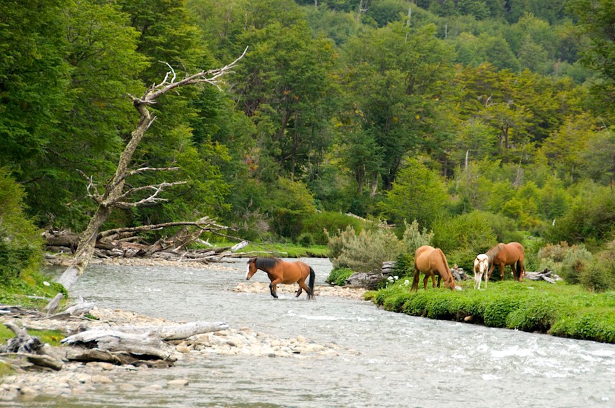
We found a quiet meadow where we camped, all alone except for a small herd of horses that were grazing the meadow and totally unfazed by our presence. There is a narrow gauge train that comes part way into the park, and it went right past our campsite; we exchanged waves with the conductor.
Ushuaia is worth every mile you have to drive to get here. The town sits on the edge of the Beagle Channel, with a mountain backdrop; it makes us think of Alaska. We have spent several nights in the parking lot of a mirador with a terrific view of the entire area, including a long stretch of the Channel; incomparable. The weather changes quickly here, and yesterday we experienced a squall that left us drenched in minutes, then passed and the sun dried us out again. Terrific. Mostly it has been warm in the afternoons, but breezy; nights can be quite chilly. The wind comes and goes and often is very strong. Andy, our local friend, described the weather as all four seasons in a day, every day; and he’s not exaggerating by much. Overnight, new snow fell on the peaks above town.
We ended our visit to Ushuaia with a gathering of several fellow travelers in a camping area beside a stream, a short distance out of town. We were seven coaches representing the countries of France, Holland, Austria, Switzerland, Colombia, Australia and, of course, the United States of America. We celebrated our joint achievement with an asado, sharing experiences and wine throughout a very chilly (46 degrees) afternoon and evening. We all were proud of what we had accomplished, but already preparing for the sights still ahead of us. Our tales were similar, but each person’s journey had been unique. It was a very pleasant day; we parted the next morning with promises to see each other again “up the road.”
Ushuaia has been a long journey south for us, but one we are glad we have made. Think back to your American history classes in school (if you had them, of course), quite a ways back for some of us, to the famous slogan “54.40 or Fight”. We can’t remember the exact reference, but it had to do with settling the western border between Canada and the US. (Fortunately, Canada won that one. Since about 90% of Canadians live below that line, we might not have a Canada today if the US had prevailed.) Anyway, when we are sitting on our lovely bluff overlooking Ushaia and the Beagle Channel we are at 54 degrees 48 minutes south! If any part of our long journey south could be called a “fight”, we guess we won this one.
As always, our best wishes to you all. Kathy, Rick and our intrepid Tiger.
Click the link to see more photos from Patagonia, Part 1.