June/July 2012
Northern Norway
Life above the Arctic Circle
The last you saw of us, we waved good-by and went trucking on up the E6, headed towards the Arctic Circle. After some discussion, we’d decided that any adventurers worth their spit wouldn’t turn tail before getting all the way to the top of Europe, and we wanted to stare at the Russian border to boot. So off we’d gone.
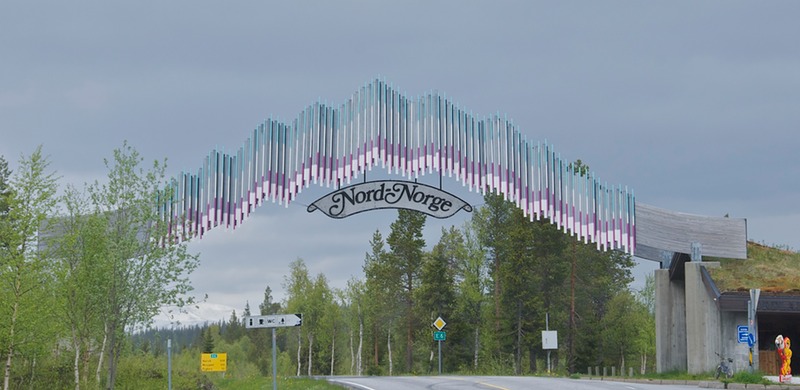
Soon enough we passed under a huge metal banner over the road that said “Nord-Norge” (north Norway). We were now officially North.
The further up you get in Norway, the more remote your surroundings, and the few major towns become signposts along the way. Trondheim, now in our rearview mirror, had been one such town. This is in part due to the nature of this long narrow country. Any map you look at has to be broken into sections and a map of southern Norway often has Trondheim up at the top where it seems to be a long way up there.Actually it’s only about a third of the way up, but for awhile it becomes a milestone of ‘up there’ in your mind. Mo i Rana (just plain Mo to the locals, and no, I don’t know what that “i” is all about) was the next goal. We strode along, moving up the map, and then decided to take a secondary road for a while, and tuck back into E6 just before “Mo.” So, at Trofors we turned east and made our way to Hattfjelldal, where we spent the night. Hattfjelldal was just a village, really, but it had a scrawny airfield runway for little planes, located right beside where we stayed the night. Saw one plane. It also had a large, just completed paved parking area complete with service facilities for motorhomes. It seemed too large to be just for us travelers, so was probably built for busses as well, but we were delighted to make use of it. The town was very busy, hammering away, erecting signs and setting up staging areas. It seems their 150th anniversary celebration was fast approaching, and preparations were underway for the party to be had.
It was mid-June, and there still was snow on the ground at 1200 feet.
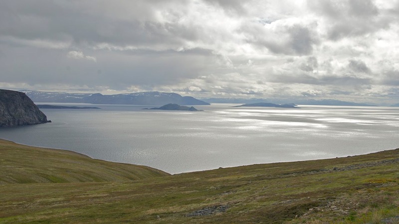
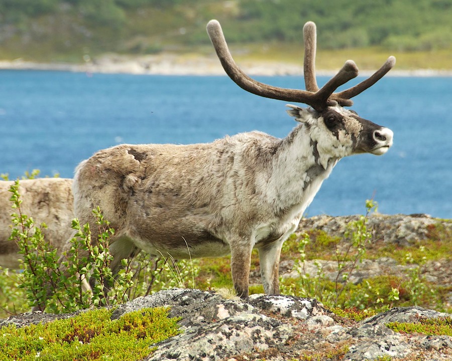
This was a lovely area, and we’d chosen a nice route for ourselves. We followed a series of little roads that passed by small lakes and tiny hamlets. There were wrinkled birches and lots of snow as we moved along at about 1500 feet; we saw our first small group of reindeer (and our first snowmobiles; parked, not running about). We went along the west side of Rossvalnet up to Korgen, seeing very few other cars for a couple of days. It was great. At Korgen we rejoined E6, and drove on up to Mo i Rana, which we simply passed by, having no need to stop. We kept on, experiencing frost-heaving of the road for the first time.
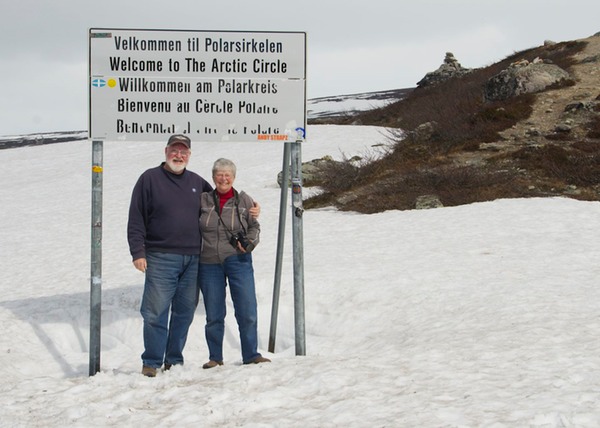
Suddenly it was June 21, the Summer Solstice. And, amazingly enough, we were going to be able to visit the Arctic Circle on that day. It’s not far above Mo i Rana, at 66 degrees and 33 minutes; on this road it was at 2182 feet in elevation, and full of snow. It was great fun (left); we took pictures, admired the fancy monument, bought a sticker saying we’d been there, and generally enjoyed ourselves.
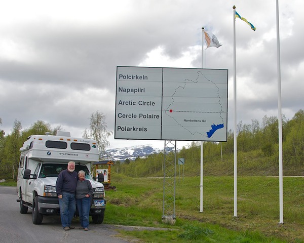
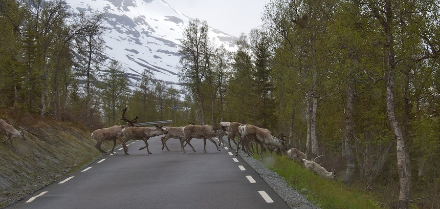
Earlier we’d seen that there was an Arctic Circle crossing in Sweden that wasn’t all that far away. Well, hell’s bells, Maude, we could bag both of them in the same day! So off we went. There was a road crossing into Sweden that took off from Storjord, about 15 miles up the road; perfect. We immediately experienced a drop in road traffic and later began seeing increasing numbers of reindeer; it was great to be on a quiet road with few vehicles. The road quickly turned southeast, crossed over a pass with fresh snow on the peaks, then on to the proper spot. Sweden takes a quieter approach to the Arctic Circle event (right) than either Norway or Finland, possibly due to the much lower level of tourist activity, but still we were able to find an appropriate sign and take some pictures. There was a rest stop there, but it didn’t look very inviting, so we moseyed a ways back toward Norway before finding a pleasant open spot for the night. So that’s where we celebrated the summer solstice, very pleased with ourselves and with two new AC crossings in our quiver. That makes four, and we’ll be in Finland later this month, giving us five of the only eight countries in the world where you can do so. (The other three are Russia, Greenland, and Iceland.) Awesome!
In a bizarre moment, at breakfast the next morning we opened the last box of cereal with Cyrillic lettering on the side; it was left over from last fall’s adventures in Bulgaria. A bit surreal, but nice.
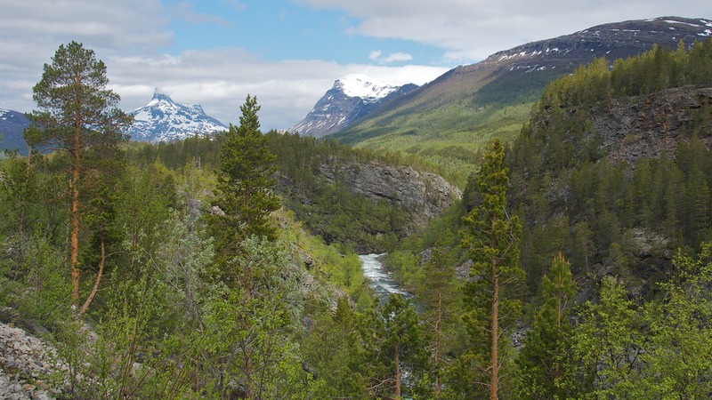
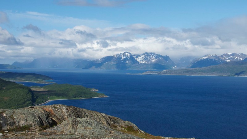
Now back on E6 (we would spend a fair amount of time on this road over the next couple of weeks, although we left it frequently to explore more out of the way areas), we pointed our noses toward Fauske and Narvik. It was a lovely road, with rugged peaks and plenty of fjords and frozen lakes. Our kind of country: we seem to have a fondness for scraggly.
Incidentally, many of you who’ve visited this area are now muttering, “Aren’t they going to Bodø to catch the ferry out to the Lofotens?” The Lofoten and Vesterålen Islands sit off the mainland west of Narvik, and they are an extremely popular destination, with their rugged peaks and classic fishing villages and dramatic views. We had decided that it wasn’t in the cards for us, and that helped us determine that we could go all the way to Russia. So sorry, guys; we’ll have to make do with enjoying your stories and pictures.
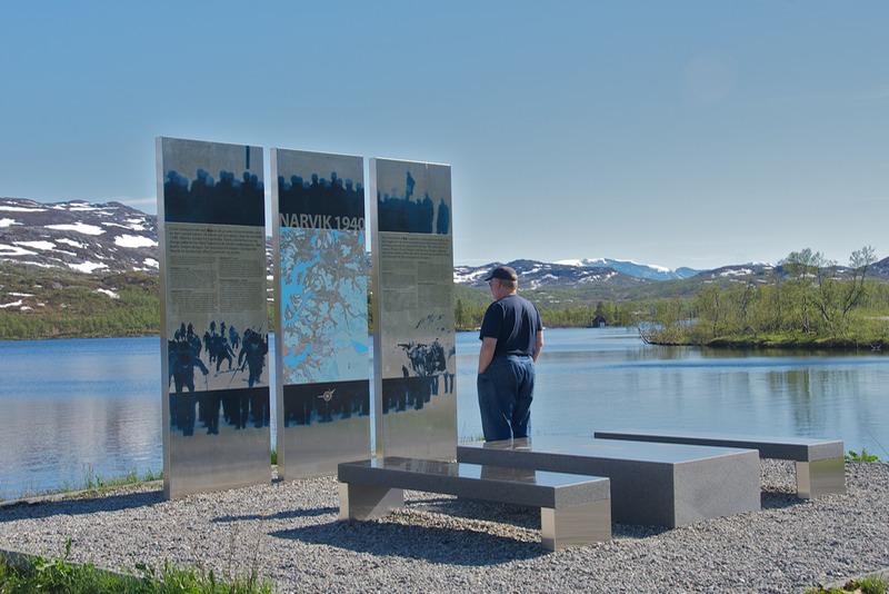
We spent a little time in Narvik, poking around. This town has some interesting WWII history; it was a strategic location because it was a year-round ice-free port, and thus very important to both sides; iron ore from Sweden was shipped from here. There are several war monuments in the Narvik area, put up by the Norwegian army commemorating small local actions. A pretty river runs through town, and it was full up to the banks; the frozen lakes and snow on the mountain peaks are now beginning to thaw and are creating lots of flowing water everywhere.
We were enjoying the transition to more northerly areas very much. The towns were a bit less “civilized” looking, the roads dustier, the wildflowers far behind those we’d seen further south (the lupine was only just starting to bloom at the end of June up here). We’d found “our” Norway – at 69 degrees North.
Suddenly one day we came around a corner and were inundated by – goats! These were no field critters; they were clean and brushed and handsome and very friendly. Several adopted Rick, and one even tried to climb into the truck when we decided we had to move on. Sorry kid; no room in the inn.
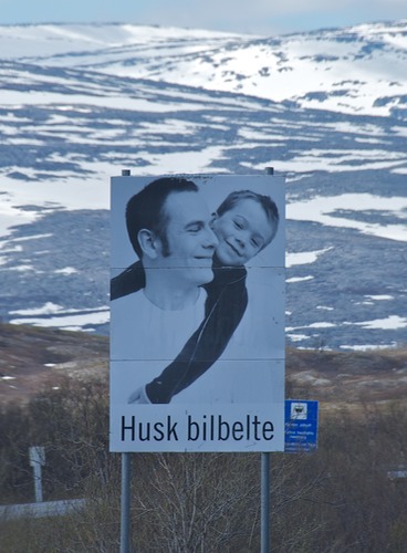
Norway has lovely roads – everywhere in the country. They take good care of them, provide plenty of places to pull off and take a break (or spend the night), water and dump stations are plentiful, etc. There are two road signs that pop up regularly: one has a picture of a girl’s face that fades away to nothing and says “Over fartsgrensen?” (Are you over the speed limit?). The other shows a father being hugged by his son, and the son’s arm is draped down from Dad’s shoulder to his waist; the caption is “Husk bilbelte” – Fasten your seat belt. We found them very effective once we figured out what they meant.
Leaving Narvik, we decided that even if we weren’t going out to the Lofotens, we needed more fjords and islands in our trip. So, heading for our next signpost city, Tromso, we veered a wee bit west off of the E6 and went out onto Senja Island and to the coast. There we joined a newly designated scenic road edging its way along. (Norway has a number of designated national scenic roads; each one we’ve been on has been a gem and has helped us to really enjoy what the country has to offer.) We went up yet another mountain, into dramatic, craggy scenery; through a nasty, ugly, and narrow tunnel; and right down to the Norwegian Sea and a wild piece of coastline called the Devil’s Teeth. It was great. The Devil’s Teeth is a rugged mountain range with sharp peaks (teeth); the surf was up, the tide was in, it was quite a scene. We really enjoyed ourselves.
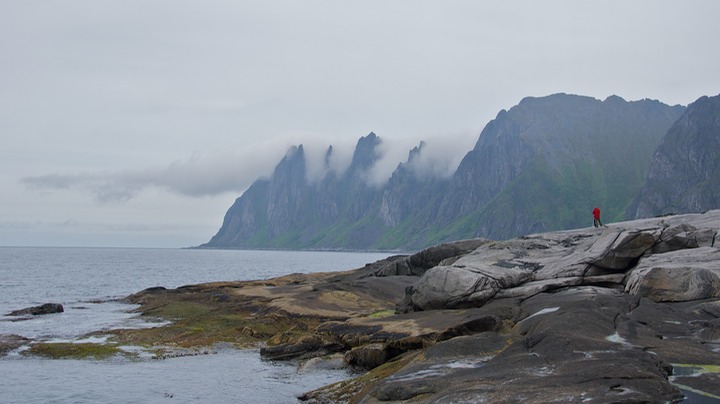
While we were wandering the seashore and taking “tooth” pictures, we were stopped by a Norwegian newsman who was doing a story for local television about the designation of the road. He interviewed us (mostly Rick, humph) about who we were and what we were doing. We had a nice chat; it seems a big party was going to be held here in a few days, highlighting the new road and the opening of the area. It’s a great, rugged place to visit. If you’ve been to Patagonia, you’ll know what we mean when we say the area reminded us of the rugged peaks of Torres del Paine NP.
After detouring on a tiny road out to Bøvær to see its pretty coral beach and some old WWII stone fortifications, we took the local ferry from Botnhamn to Hillesøy, and spent the night in the parking lot of the local church, enjoying the windswept beach nearby.
The next morning we took a small road along the south shore of this agricultural island, Kvaløya, stopping at a very exciting (for me) helleristninger or rock carvings site right beside the road; way cool. I took some pictures while Rick attempted to chair a roundtable discussion among our 3 map sources (which had been acquired in different countries) and the GPS – no two parties could agree on our present location. He finally mediated consensus, and we moved on. Our contribution toward world peace.
By the next day we were in Tromso, with its wacky tunnels underneath the city. A good spot to do some shopping, but first we had to negotiate those tunnels. There is actually just one set…we think. There are lots of twists and turns, and parts going off in different directions, and even 4 roundabouts at various points. No surprise -- we got quite lost. We had to navigate one roundabout a couple of times before we were able to pick up the signage that would take us in the right direction. I started humming the old Kingston Trio song about getting “Charlie off the MTA.”
Finally escaping, we were able to do some shopping. You see, as you get further north, starting in Denmark, everybody says to stock up on stuff; “it just gets more expensive the further along you go.” So we did, in Denmark; then in Sweden; then in southern Norway; and now we were really heading out into the far northern nooks and crannies. So at each step of the way, we added more foodstuffs to our horde. La Tortuga was beginning to wallow down the road. We could hibernate over the winter up here with all the food we’re carrying!
Actually, we felt that the changes in price were less dramatic than we’d been told to expect. It’s true that groceries were considerably more costly in the far north, but we always found nice stores with pretty much everything we wanted available in them. Certainly we saved money by stocking up lower down, it just wasn’t as bad as we thought it would be. The same was true for diesel, but even more so. We kept our tank pretty full on the way north expecting to see a jump in prices, but the difference between the price in Oslo and that in Alta or Kirkenes was considerably less than 10%.
Leaving Tromso, we navigated several more fjords, by ferry or by traveling the squiggly road along the edges.There was very little traffic on these roads, mostly folks flitting between ferry ports. Quiet and lovely, and very enjoyable. We had a dramatic drive through the Lyngsalpene, the Lyngen Alps, before rejoining E6 at Olderdalen, and shortly the road started climbing up into the mountains. Suddenly we reached the top and a great panorama unfolded before us. The weather was clear for a change and it was stunning. On beyond Storslett we started seeing lots of reindeer along the road. There were also plenty of signs for shooting ranges – skytebane – maybe to help folks get ready for “the season”?
We’ve coined a couple of words for some regular sightings: Bobilbevy and Tourbussites. “Bobil” is the Norwegian word for motorhome. A Bobilbevy is a group of RVers all traveling down the road in a convoy. Tourbussites are those folks who pile off the bus, follow their guide through the museum looking bored, and are ready for their lunch at least an hour ahead of time; like mosquitoes, they’re only a problem when they swarm. All kidding aside, everyone we’ve met this summer has been charming and seems to be having a splendid time enjoying themselves.
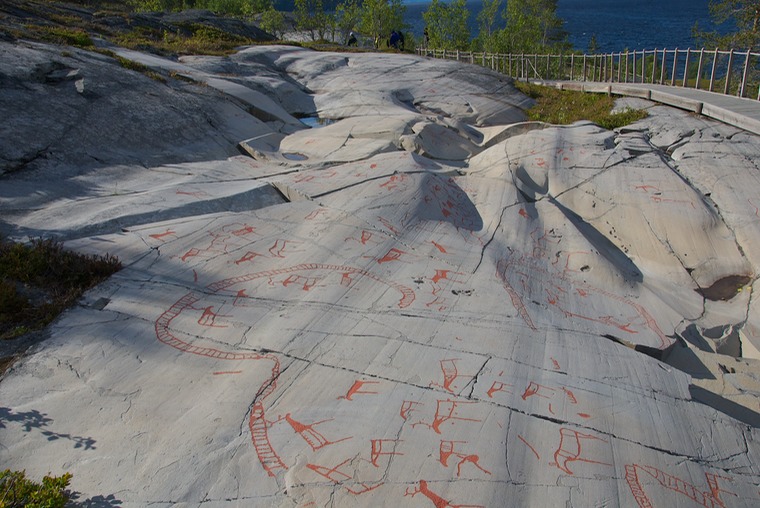
The next great destination on our road toward the top end of Europe was the pleasant, roughhewn town of Alta, home of the rock carvings at Hjemmeluft, a really cool UNESCO site. The oldest carvings go back to 6200 BC, and the entire site is really impressive. The setting is lovely, spread out on a hillside not far above the water, with the museum at the top. There is a very nice boardwalk amongst the rocks and through the stand of birches along the slope. The carvings were magnificent.
It was quite a moment for me – actually a whole bunch of moments. I wandered for a couple of hours, including taking in the very informative museum. It had lots of detailed material on rock carvings in general, life in the area “back in the day”, and a good introduction to the coastal Sámi lifestyle. A decided treat. We spent that night a little further up the road, in a pretty park along the water. Alta was a really good experience.
Shortly after leaving Alta, we crossed 70 degrees north; progress was being made. The tree line now stopped at about 600 feet in elevation. We were already further north than we had been in Deadhorse, Alaska on the most northerly road in North America.
And now we made our second big decision about The Trip to Norway. We voted down visiting Nordkapp – the North Cape – supposedly the northernmost point in Europe. It was so described by an English explorer back in the 16th century, but more recent technologies have long shown that he was mistaken. The true most northern point is actually Kinnarodden, a remote headland about 50 miles further east on an entirely different island. Unfortunately it is largely forgotten, with no road going there and a 15-mile hike needed at the end. All the tourist hype says, “This is The Place to Go”, referring to Nordkapp. But…it’s a money trap, tons of folks go there to stand and take a picture, and it’s just not our kind of thing. It’s very expensive and until just this year, actually the week we were there, you had to go through a very expensive tunnel in order to get there. You still have to go through the tunnel, but as of June 30th the tunnel was paid for and the toll discontinued just as the government said it would be; how about that. Nonetheless, tons of folks do go, about 200,000 per year they say. For reasons of cost and just plain stubbornness we decided not to go to Nordkapp, and since we are not up to speed on 15 mile hikes, we chose to go to Havøysund instead to find our own ‘north cape’ experience.
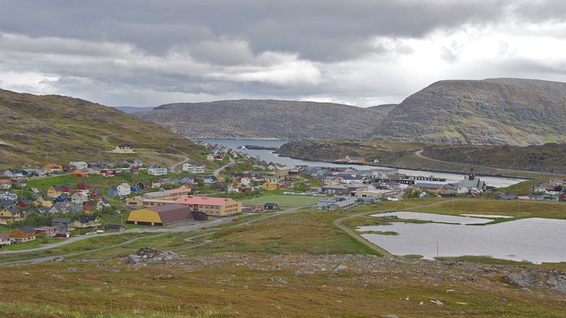
Havøysund is a great little fishing village and ferry harbor at the end of hwy 889, a detour off the E6 and another national scenic route. We took lots of pictures getting to the end of this lovely coastal road; it was quite dramatic. The town is pretty darn close to being as far north as you can go (71.01 degrees instead of 71.10 – about six miles in a straight line) and…it was quiet, it was free, it was ours and there wasn’t a single art gallery or souvenir shop in the entire little town.
We had a really enjoyable time. We wandered the town for awhile. Talked to the local community office staff (as in single person). Yes they had a library, but this was late Thursday and they had just closed and wouldn’t be open again until next Tuesday. No, it doesn’t have an internet connection. Well, you might be able to get some wifi if you take the little road that goes down under the bridge and drive all the way to the end – some “foreigners” say that has worked. Or, you see the little shop up the street there? Somebody said they got coverage when they sat on the bench in front of it. We loved it.
We were able to track down and talk to the big Hurtigruten ferry guy (the office was closed but when I pounded on the door he stuck his head out from around the corner). We were interested in finding out if we could get on one of their big ferries and sail around the top of the country to another town we were interested in – saving miles and time, and having a new experience. But no, they aren’t really that kind of ferry service; they take cars as a convenience to their passengers, but we were too tall to fit into the belly of the ship. That’s only on the fjord runs. Oh, well. The Hurtigruten route is from Bergen to Kirkenes, and if you take one the entire distance, the trip lasts 13 days. It’s supposed to be the quintessential Norway experience, and certainly would be a doozie. Ah well, another time.
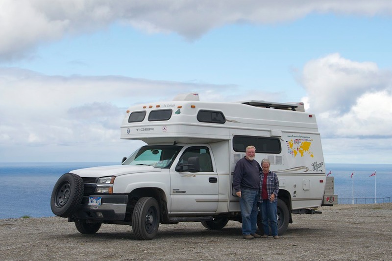
We drove to the end of a dirt road we could see from town and up into a wind farm on top of the bluff. We could see for miles out over the Barents Sea. We parked the Tiger and took pictures of us at “our” top of Europe. We were quite pleased.
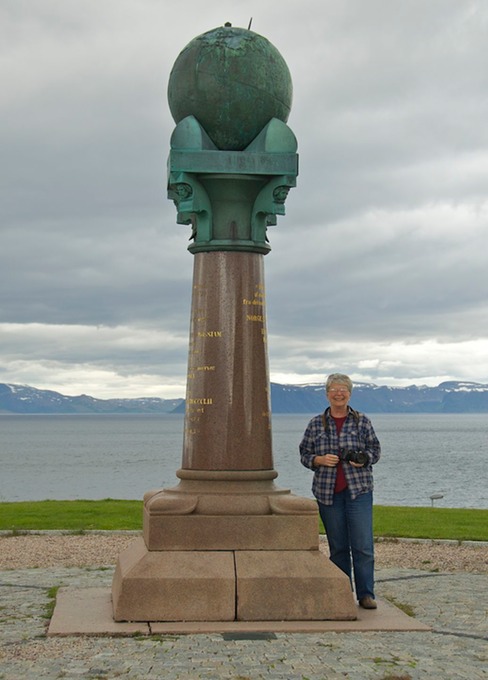
We had lovely full sun all afternoon and until well after we crashed for the night. We drifted off to sleep in full sun, then overnight the weather changed; it got cloudy and extremely windy, with amazing gusts you could hardly stand up in. Now we knew why a wind farm was located here! Before leaving town, we made one last stop, at The Cairn (the locals just call it “the globe”). It was erected to mark the 71st Parallel and the monument does indeed have a globe on top.
We really enjoyed our visit to Havøysund, and felt it was far more rewarding than any other way we could have paid our respects to The Top of Europe. Put it on your list!
On our way back down to pick up the E6, I realized I wanted to make a detour. It was cool with Rick, so we did a little backtracking, and took the road up to the city of Hammerfest. Now this was one ugly town. Not on our list of really cool places! But it is home to the Struve monument. Say what? Well, Struve was the guy (a Russian) who, in 1854, completed his nearly thirty year study that determined with much greater accuracy the shape and size of the earth. The northernmost of his triangulation measurements was at Hammerfest; from there they run all the way down to the Black Sea, through about ten countries. His was a great feat and the surviving sites are collectively on the UNESCO list of World Heritage Sites. A commemorative monument was erected in Hammerfest, and we have the pictures to prove it. It added a few miles, but Hell’s Bells, Maude!
Back on track, we marched onward. Beyond Alta, as you start moving east, town names start being in more than one language: Norwegian, Sámi, and a language that was explained to us as being an early, local version of Finnish (I think I have that right). It made for cluttered signs, that’s for sure, but we couldn’t read any of the languages anyway so it really didn’t matter to us.
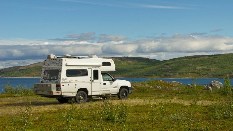
Wanting to take a few days off before heading to the junction town of Lakselv, we spent 3 nights on a bluff off the road and above Porsanger bay . Shortly after we stopped, a group of reindeer visited with us for awhile before moving on to new munching grounds. It was so cool to have them right outside our windows, and the sun was even shining down from a clear sky; a rare enough occasion on its own. We didn’t see them again, but there were several sheep (mommas with two babies each) that came through each day – about once each hour – announcing themselves by the bells around their necks and their complaining little ones. Come on, Mom, can’t we stop for awhile; I’m hungry and thirsty. All kids are the same (oops – kids are goats, huh).
While we recuperated from all the miles we’d been covering, we congratulated ourselves on our choices of route. We’d covered a lot of ground and seen a whole lot of interesting places. The far north is always an area we enjoy very much; this part of Norway is called Finnmark, and it suited us just fine. We love the barren and the bleak, to say nothing of the bogs! Our favorite kind of countryside. It was cool and windy and cloudy much of the time, but it kept the bugs down and the sunburn to a minimum. We were in lonely and distant places, and pretty much had it all to ourselves.
Ready to go on, we mapped out our route through the rest of Norway and then south into Finland. We stopped in Lakselv for internet and fuel, and stayed most of the day – the winds were very strong and gusting and being outside wasn’t much fun. We made a temporary home in the tourist office, chatting with Sophie and using the free wifi there. She’d spent several years in the States, and had lots to say on lots of subjects. We had a lot of fun.
At Lakselv, E6 turns south for a bit before heading east to the end of the road at Kirkenes. We went north instead, up Highway 98 all the way to Tanabru (Tana is the river, and “bru” means bridge = so simply a river crossing point that is a Sámi village). The area was very stark and lonely. We spent a night in a wood (the Børselv Wood to be precise), where there is a stand of birches that is home to the northernmost appearance of any pine (Pinus sylvestris) in the entire world. That was neat. The birches are the main tree up here, and they get scrawnier and scrawnier as you get further up, until finally there are no trees at all much of the time.
The car compass is getting a little wacky, and sometimes we have to ignore it; the GPS is correct, though. Norway’s roads have been beautifully finished, but now only some of it is paved, with construction crews working on other parts. We think Norway is preparing this road (the 98) to be upgraded to “E” status.
There is snow on the ground – it’s the 4th of July.
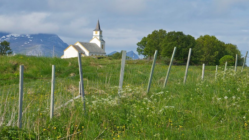
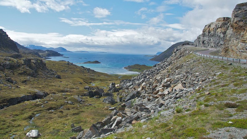
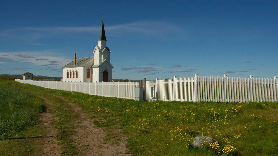
Crossing into eastern Finnmark at Tanabru, we entered a kinder and gentler part of the far north. The effect of the Gulf Stream is quite strong here. We picked up the E75 at Varangerbotn and headed out along the north side of the Verangerfjorden toward Vardø. Amazingly, the area was lush and green and the air warm and breezy. This was a “softer” coastline with lovely wildflowers, boats in the water, and with a definite vacation area look to it. We spent the night in Nesseby, parked near another coastal church on a bluff out into the water. It was a terrific spot with lovely views.
Coming back to the head of the bay and turning east again, along the south shore, the terrain was totally different. We were back into dry areas with boulders and barren hillsides, some of them covered with stubby bushes. There was still some green, but no wildflowers to speak of, that’s for sure. We enjoyed it every bit as much, though.
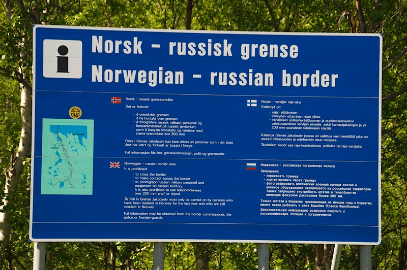
We ended up in Kirkenes, the end of the road on E6. But there’s a smaller road that keeps going, and so did we. We went along, finally reaching the Russian border. You can’t just walk across, of course; border guys always mean business, and especially in Russia, judging by the warning signs. The road paralleled the border for several miles and then finally came to an end at a wide spot in the road called Grenske Jakobselv. This is a real destination for folks. There is an old church, and an area where you can park for days among the boulders. The beluga whales come by, and it’s supposedly a great spot to watch the midnight sun.
We had intended to spend the night, but there wasn’t even a place to park; too many other folks had the same idea we did. So we got a look at the whales (they were in gay profusion, that’s for sure), snapped off a few shots of the very interesting church that had been built in an effort to calm border disputes, and headed back toward Kirkenes. Along in here, the road runs alongside the river, and the river is the border. We took some pictures of nondescript bushes about fifteen feet away only because they were in Russia, but spent the night a bit further back toward civilization.
We ended up the night parked in a large open space near a pretty little pond, and we were joined by a German couple we’d actually seen a couple of times at other points along the road. We chatted with them for quite awhile, and ended up making friends with Wolfgang and Andrea. We will certainly meet up with them again, the next time we are in Germany; they live near Limburg. Incidentally, we call this the Patagonia Effect. When you get closer and closer to the end of the road, and there is only one path to travel, you keep seeing/meeting the same people; we’re all going in the same direction with the same ultimate destination.
The next day we spent some time in Kirkenes, taking care of business and seeing the sights. There is an excellent museum in town, the Grenselanemuseet or Frontier Museum. In very personal, local ways it discussed WWII and its impact in this corner of the world. The Kirkenes area was very heavily bombed during the war, totally destroyed and putting the entire population at risk. Germany fought hard here, and was impossible to defeat without the help of the Allies. And here, at this one time in history, the Russians were our allies. The Norwegian partisans were working with them, and Russia liberated Kirkenes in 1944.
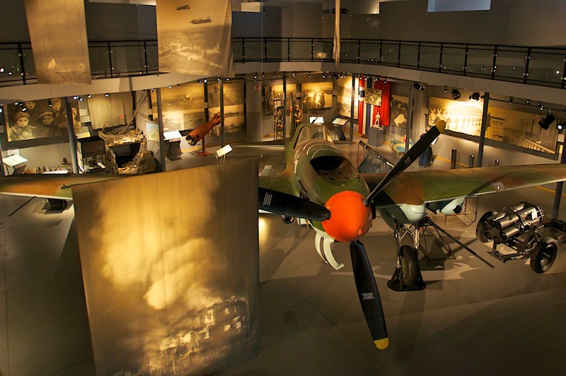
The featured item in the museum was a Russian bomber. Its history was well documented, from its crash landing in a lake in 1943 to its eventual recovery in the early ‘90s. After the local volunteers had struggled with attempting to restore it, the factory where it was built came and got the plane, completed the restoration and returned it to the museum; all at the expense of the Russian government. It was quite a story.
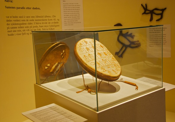
The museum also treats the relationship between Finnmark and Russia over the centuries, and the Sámi presence in the area. Before there were international borders, the Sámi and their reindeer moved freely throughout the area. No longer true, and modernization has been quite difficult, although there is much evidence that the Sámi people are thriving. We will be entering northern Finland very soon, and expect to learn more about the Sámi people there.
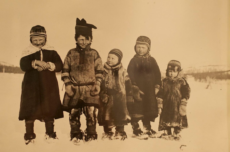
There were tons of pictures at the museum showing this area back a hundred years or so; they were absorbing and informative. We spent a long time here, and left knowing a lot more than when we had started. It was just plain excellent.
Oh, also at the museum was a gallery of work by the Sámi artist John Savio. His woodcut paintings were terrific and very evocative of the life of the Sámi in this area. I could have taken them all home with me.
After two lovely, sunny days in the Kirkenes area we moved on. We drove E6 back as far as Neiden, then took a left turn down Highway 893 toward the Finnish border. After a month in Norway, we were ready for new adventures.
We waved adios to the constantly changing weather (and just as constantly changing terrain) we’d enjoyed in the far north; the ever-present water in all its various forms: snow and ice, waterfalls, fjords, and overflowing streams; the severe tilt of the satellite dishes as they tried to catch as many waves as possible; the helpful strangers always curious as to where we’d come from and where we were going.
But we cannot say good-by to Norway without a few final thoughts. It’s an incredible country to visit, with dramatic scenery, interesting places to visit, and interesting history. Ideally, it probably deserves an entire summer devoted to its exploration. We know a number of European travelers who have returned time and again to see more of the country and to revisit the stark beauty of the far north.
What else can you say about Norway that hasn’t already been said? Is it gorgeous? Damn straight! Expensive? Hell yes! Lots of miles? Yup –- we traveled 3100 miles in 32 days at about $8.50 per gallon for diesel fuel (there went our travel budget for this year). Are we glad we did it and do we suggest you put Norway on the top of your list? Of course. It’s a beautiful country with incredible scenery and much to see and do. You don’t want to miss out.
But for us, Finlandia was calling and we could hardly wait to see what she had in store for us. The land of Jean Sibelius awaited. We slipped across the border, dodging reindeer, and trucked on down the road.
Rick and Kathy and a slightly chubby La Tortuga
Click to see more photos from Northern Norway