April/May 2013
It’s a Whole New World
Eastern Turkey, the Cradle of Civilization
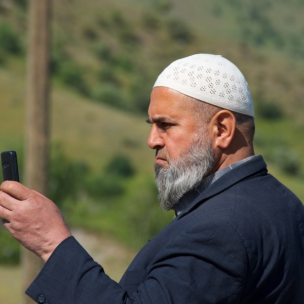
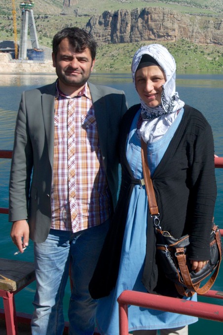
We don’t know if there is an officially recognized dividing line between western and eastern Turkey, but when we crossed the Ataturk Baraji (reservoir) east of Kâhta, we felt that we had entered a whole new world. As we backed onto the little ferry, and sat watching the foot passengers coming aboard, the change was immediately apparent. We were reminded of our trip to Morocco. These were not western Turkish folks. They might make a trip to Istanbul or to Ankara, but their home was here in the rugged eastern countryside. The women wore brilliantly colored clothes and head scarves and weren’t automatically submissive in attitude; long beards were the fashion for the men; faces and skin tones were different; and bright laughter was heard everywhere. It was a bright, sunny Sunday, and a ferryboat ride was part of the day’s fun. We were delighted to be among these happy folks. We made the acquaintance of a couple in their 30’s, heading home to Muş where he is a teacher. She was quite pregnant with her first child, we shared hugs and wishes for an easy time of it.
The boat ride was a great introduction to what has been a really rewarding 3 weeks here in the east. We’ve been able to spend time communing with both the Tigris and Euphrates Rivers (or as they are known in Turkish, the Dilce and the Firat), locating them in out of the way places where they ran lovely and free.
Turkey is, indeed, the Cradle of Civilization; both of these rivers rise here. We’ve traveled “the scorching flatlands of upper Mesopotamia;” seen Mt. Ararat; visited several Kurdish strongholds; poked around the archeological dig at Göbekli Tepe, where they’ve discovered the oldest known man-made religious structures in the world; and been to the ruins at Ani, the amazing medieval Armenian city that sits on the rim of a gorge that forms the border with Armenia. And that’s just the short version of the story.
Getting off the ferry was a very big production. There was a huge line waiting on the other side, and some folks were anxiously trying to make their way aboard at the same time we were trying to drive off. You have to back on to the ferry; some of the cars and trucks were having a difficult time. There were big busses and dolmuşes (vans). It was quite a zoo. The government is working on building a bridge to replace the ferry; it cannot come too soon for this busy crossing.
The Atatürk Dam is the centerpiece of the enormous GAP project, begun in 1974 and still underway. The GAP project has dammed and spread the waters of the Tigris and Euphrates Rivers, turning large sections of the plain into productive fields. The dams have changed this part of Turkey forever, for better and for worse. We cannot help but wonder how Iraq and Syria, downstream, feel about all this.
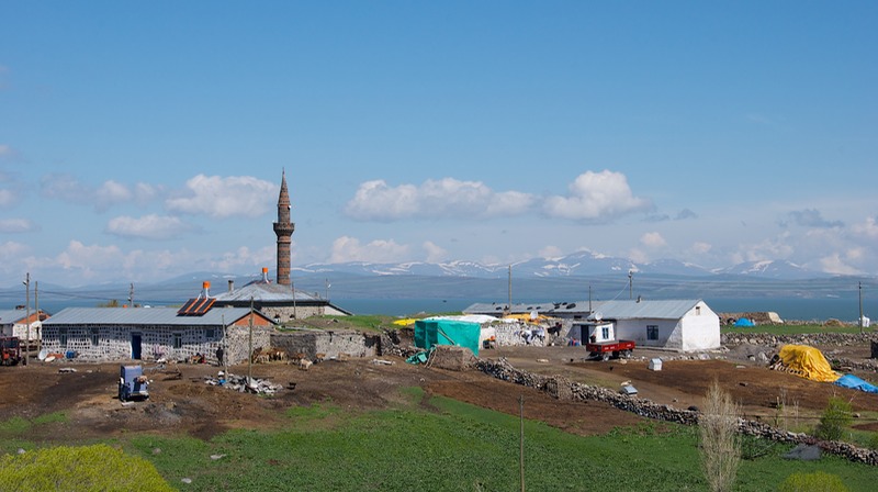
Driving away, we were heading for Sanlıurfa, known to all as Urfa and often listed on maps (and by Google) as Edessa. (It’s always like this; you get used to it.) The land was barren and dry. Horse-drawn carts were plentiful, as were stone corrals and buildings. And out here on the plains there were no longer springs from which to get fresh water; we had been so used to them further west. From here on out the towns would be serviced by water storage towers.
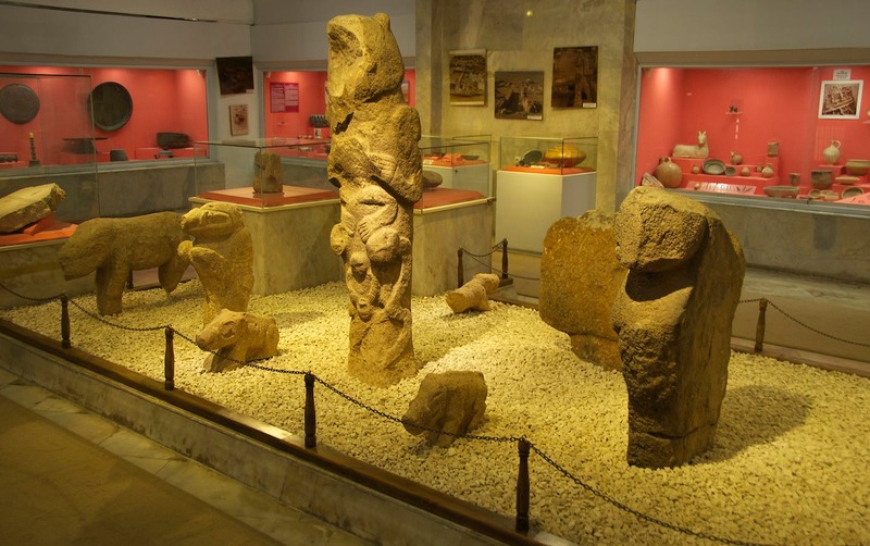
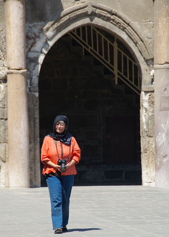
Urfa was such a great place; a really nice town. We arrived on Sunday afternoon, and all of Urfa was out enjoying the lovely weather. The old town was jammed, so we figured we’d save our visit for Monday morning, and sought out the small museum that was located elsewhere. We were rewarded with easy parking, a quiet visit, and some gems -- including what is said to be the earliest anthropomorphic statue yet found. It was located in a city that dates back 11,000 years. There were also several figures from Göbeckli Tepe, which is nearby.
The following morning was quieter in the park and castle area, although there certainly were plenty of people about. Urfa is a pilgrimage city, and an important destination. We took tons of pictures of people, many in very interesting and different attire.One woman came up and chatted, asking if we could take pictures of her and her family, and send them to her. She spoke excellent English; we found out she was a teacher, now retired to raise a family. She and I shared a hope that she would find her way back into the field after a few years of being at home. We are finding that very often, if we are approached by someone who speaks good English, it turns out that they are teachers.
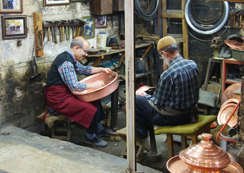
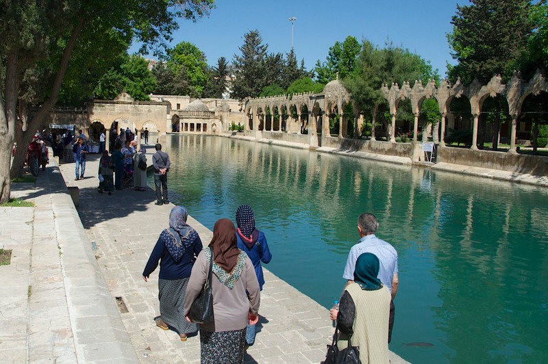
We had a lovely day in Urfa. The old city is centered around several religious sites, a castle and a beautiful park and palace. We wandered forever, enjoying ourselves very much. We ended up in the famous bazaar, which was most intriguing. We got lost, of course, but found the coppersmiths’ section, which was fascinating. The copper was being worked over the fires, or hand-pounded, or having designs worked into it.As always, the men were just as likely to be sitting and talking over tea as working the metal. In the small open areas, there were peddlers of loose tobacco (by the huge bag, with lots of people buying), as well as produce and fabric and anything else you could possibly think of – oh, yeah, and the zipper seller, too.
The grounds of the park, which is at the foot of the castle, were filled with people having a snack on the grass, or visiting the pool filled with fish, or buying a new scarf, or enjoying what I finally discovered were very young, green plums (erik); a policeman identified them for me and called them “turkish delightful” – I just thought they were unripe fruit. An acquired taste. Since that day we’ve seen them many times being sold in stores and beside the road.
We had lunch in Urfa and I got to try a local delicacy, Lahmacun. It’s flatbread with spicy lamb spread over it and then baked like you would a pizza. Quite yummy.
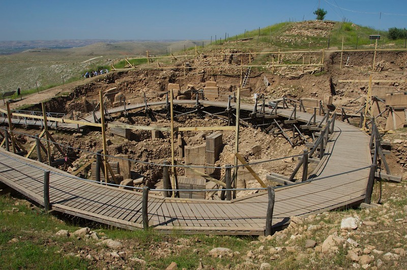
And then, the next day, we spent some good quality time communing with the Neolithic crowd out at Göbekli Tepe. This is a small site, at least so far. They’ve uncovered several circular chambers containing really interesting anthropomorphic figures, and modern technical magic has told them there are many more chambers waiting to be excavated. The site is recognized as being the earliest known spot demonstrating religious architecture, and is redefining what we know about the transition from hunter gatherer society to settled communities. We watched the men at work, carefully uncovering areas and removing dirt. Then it was about 9:45; we knew the time because they all suddenly stopped working and gathered for tea. Like clockwork. We had the place to ourselves, although if we’d wandered off somewhere we didn’t belong I know the man in charge would have been right there heading us in a different direction. But this is an amazing place. Cradle of Civilization indeed.
Our direction is east, ever east, paralleling the Syrian border, but staying far enough away to feel comfortable. (A week or so after we’d moved on out of the area, a bomb went off in the Hatay region, which we’d decided to skip because of its location. We may be nuts, but we try not to be crazy.) It was getting increasingly hot, hot, hot. We weren’t happy about this, but knew it was inevitable. The “scorching flatlands” and all that.
We’re in amongst the Kurds now. In the past, unrest in this geographic area because of the political situation has made things tense. But this spring has seen a change in the Turkish government’s politics; there is apparently a reconciliation underway, and we are frequently being greeted with “I am Kurdish – AND I am Turkish” and gestures of goodwill. It’s exciting, and we’re glad to be enjoying the result. Nevertheless, we’ve put away our Turkish flag for the time being, the one we always attach to our antenna when we stop for the night. It always makes us feel part of the community, but for the moment it is tucked away.
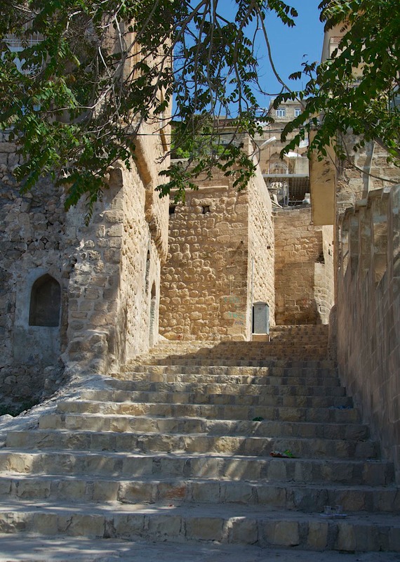
We spent a couple of pleasant hours in Mardin, about 30 miles from the border, wandering the steep streets and peering into the Medresesi to see the lovely architecture. Until recently, this Kurdish city, which has been a center of strife, has been a bit risky, but all seems stable here now. It’s a pretty city, built on a steep hillside (with the ubiquitous fortress on top), and the local stone is honey-colored and soft, lending itself to intricately carved details in the old buildings. Being built on the side of a steep hill, we had the usual interesting time getting settled for our visit; leaving was even worse, as the tiny street wasn’t one-way (as we had presumed); we paid hell getting out of there. (See the pictures for proof!) But well worth it.
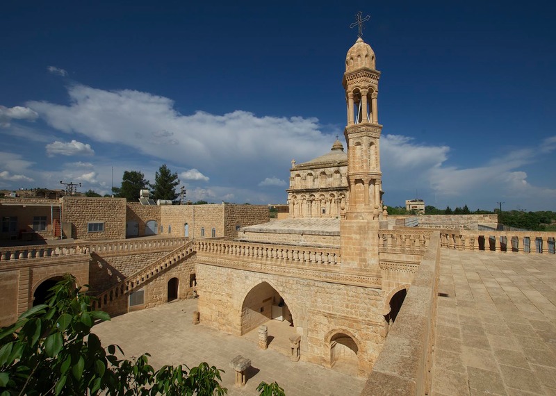
Moving up into the hills above the plain, we passed through Midyat and on to the fascinating Syrian Orthodox Monastery nearby. Along the way we began passing groups of people with equipment, animals, children etc., heading out into the fields to plant, or moving large herds of sheep (or goats) to new pasture. This would continue throughout the rest of our time in eastern Turkey. These seemed to be nomadic people, with temporary encampments in the hills. It was awkward to try and ask.
The most beautiful Syrian Orthodox building in Turkey is reputedly the Church of the Mother of God near Midyat; we would agree. It’s set in a tiny village, and we wound around narrow back roads until we finally found it. Serene and lovely, in a pretty setting, it was a delightful experience. A local teacher, acting as guide, kept us company, but we could go wherever we wished. Recently restored, it was amazing. And then, we had tea with our guide… and the priest. The father had no English, the teacher just a few words, but we had a very pleasant half hour together. It being shortly before Ascension Day, they were fasting, but we were presented with yummy tidbits to go with our tea. It was late in the day when we finally left, and we only drove a short distance before settling down for the night; the countryside was quiet and serene.
The next day we turned north, leaving the area of the D-400 highway, which heads across southern Turkey straight to Iran, with exits along the way to Syria and Iraq. This is a major trucking road, and we’d seen construction materials, enormous numbers of new cars, equipment, you name it, along the way; a very busy road. We were happy to leave it (and the Syrian border) behind. We like little roads better.
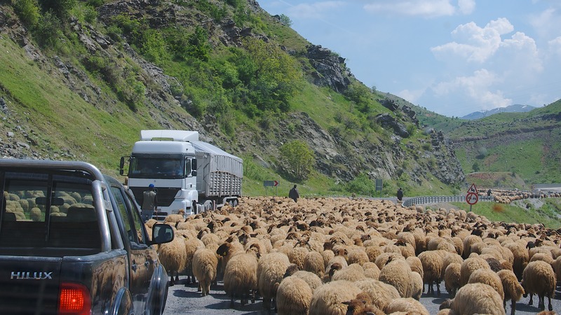
We were off in the direction of Diyarbakır, headquarters of the Kurdish people and a fascinating old city to visit. On the way we stopped at the riverside town of Hasankeyf, to see the remains of an old Roman bridge… and to cross the Tigris River. Along the way we encountered more enormous herds of hundreds of sheep traveling along the roadbed; the shepherds keep them moving right along, but they take up the entire road. Traffic slowly edges by in both directions, with the critters reluctantly moving to one side or the other… or both… or neither. It’s very chaotic. The shepherds are quite businesslike about the process, and obviously know their job well. I suppose if they let the sheep off onto the hillsides they’d simply stop to graze and never make any progress at all.
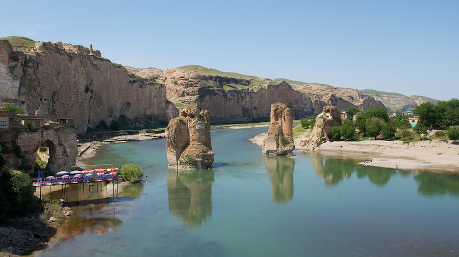
Finally reaching the river, we stopped to look at the spectacular ruins, and to enjoy the quiet, green waters of the river. There are supposed to be very important prehistoric caves here, and Selçuk sites, but access was totally blocked by a series of tour busses and the mob scene they can create. We passed up the opportunity. Sadly, they are slated to disappear in the near future, as the damming of the Tigris River is causing the waters to rise and they will be flooded. There has been a huge bruhaha over this eventuality, but we’ve not heard it’s going to do any good.
But we enjoyed our visit, and the chance to see the mighty Tigris up close. While we were wandering around, we were approached by a group of pre-teen girls who were curious about us and the Tiger. One of them, upon arrival, drew herself up and announced “I am God; how can I help you” – all this dressed completely in pink and with a paper clip attached to her upper lip. And grinning widely.
Finally tearing ourselves away, we followed the Tigris River upstream to Batman. (Dracula may come from Transylvania, but Batman is in Turkey.) In this area the Tigris cuts quite a swath in the earth, with a huge cliff on one side keeping it where it belongs while it meanders in soft sandstone on the other. There were rock caves galore. This river valley is a vast green plain; a lot like the American Mid-West.
In Batman we stopped for fuel, which led to tea while sitting on pillows under a raised canopy. Our host spoke no English, but he called a friend on the phone to translate the conversation back and forth. And then we were treated to a total car wash. How great!
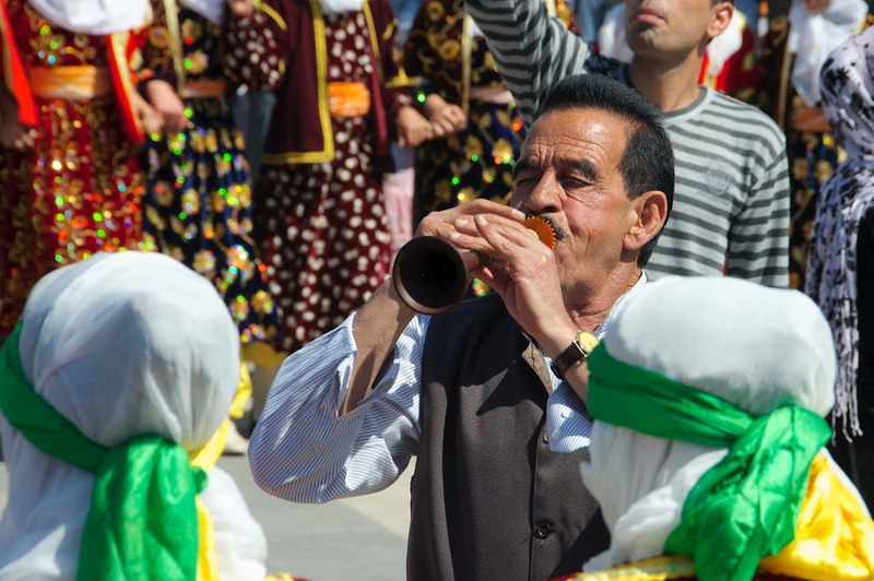
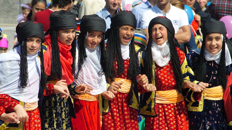
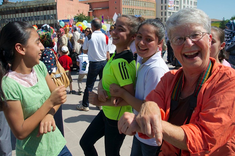
Not wanting to head into Diyarbakır late in the afternoon, we settled for the night in a fuel station on the outskirts of town, and drove in early the next morning. We found a great parking spot just outside the old city fortress walls, got out… and found ourselves in the midst of what appeared to be a huge party. When we finally found someone who spoke English, they explained that it was a city-wide dance competition – kids of various ages in different ethnic costumes, along with parents taking pictures and adults joining in the dancing and small children wearing the kinds of things little kids like to dress up in -- you get the picture. We spent hours watching the fun and getting caught up in the dancing, enjoying the high energy around us and making friends with the locals and taking their pictures – just as you might expect us to do. It was a complete hoot. Finally, it all ended and we collapsed over lunch. It was very hot here, but we’d had a wonderful time.
In the afternoon we set out to explore the old city. We visited mosques and an old Armenian church that had just been restored (finally getting a roof), an even older Chaldean church, and several other interesting buildings. This city is full of things to see; we were so glad we’d come. The people were very welcoming; we were offered tea at every turn and given advice on what to see, how to get there, and what to watch out for (apparently small purse snatchers are about).
This city is said to be the most Kurdish in the country and has been a hotbed of unrest for years, and there still is a large police presence. We saw riot tanks parked outside the police station, and there is plenty of razor wire protecting buildings. But everywhere we were hearing the phrase “I am Kurdish… and Turkish.” We felt very comfortable and could have stayed for days.
At day’s end we headed out, curled up for the night at yet another friendly fuel station, and the next day moved further east. We climbed up off the Upper Mesopotamian Plain, and were delighted to gain some altitude; enough of this hot weather, thank you. Increasingly, there was a military presence along the roads, although we were never stopped, ever, all the way across eastern Turkey. We drove past checkpoints, both manned and unmanned, noted the occasional tank parked in front of the jandarma station, and passed several large army bases.
Something new: construction is rampant, as this area develops following the dams’ being built. Concrete blocks are being made everywhere. There are big enterprises, small home projects, blocks being made on site, blocks being hauled along the highways in enormous trucks; it was surprising to us.
We’ve not returned to the plains and hot weather. Our route from here on has taken us higher into the mountains, into more rural and remote areas, onto high plateaus and into forested areas. The countryside was ever changing. Housing became simpler – stone or concrete block with thatched mud roofs or even sod roofs were very common. The roads were still good, although rugged and sometimes narrow. The streams had lots of water in them, and the patches of developed land went high up the hillsides.
Our next destination? Lake Van (Van Gölü) and all it had to offer. The city of Van lies on the east end of this enormous lake, elevation 5740 feet and only about 60 miles from the Iranian border. The Iraqi border is a bit further south. We started seeing snow on the mountains, and spent a chilly night in Bitlis at 5850 feet. While there, we were approached by a couple of European fellows in an overland-type rig. They were heading towards Iran, and wondering if we had any current info on how the border crossings were going these days. Couldn’t help them out, but wished them luck and an easy passage. Their ultimate destination? India.
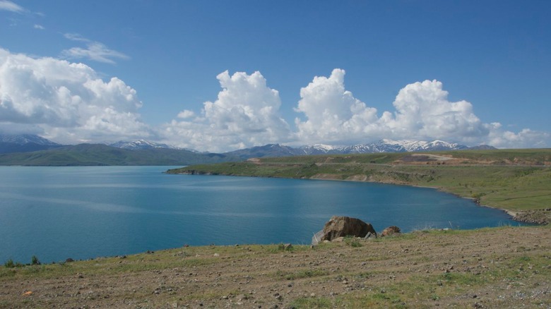
We spent several days in the Lake Van area. It’s lovely here right now; spring has arrived and there is fresh grass and plenty of wildflowers. The days are mild, but the nights still chilly, and there’s still plenty of snow on the peaks.It’s almost mid-May. The lambs and kids are very small, and sticking real close to mommy; the streams are full and the water is rushing right along. We parked along the west side of the lake for a couple of days, enjoying the nice weather, and then headed north to the village of Ahlat.
Ahlat is an ancient Urartian and Selçuk site. We were in town to visit the cemetery there. We talk a lot about the amazing history we are learning as we travel in Turkey. Rough Guide, our trusty guidebook, says about the area:
“First an Urartian, then Armenian settlement, Ahlat fell to the Arabs during the 7th century, was retaken by the Byzantines 200 years later, and passed to the Selçuks after the nearby Battle of Manzikert in 1071. The Mongols arrived in 1244, succeeded by the Ilhanids a century later; by the 1400s Ahlat was the main base of the Akkoyun Turcomans. Even after the local Ottoman conquest of 1548, real power in this remote region remained in the hands of the Kurdish emirs of Bitlis. Ahlat was a populous polyglot city until World War I.”
And you thought your hometown was historic!
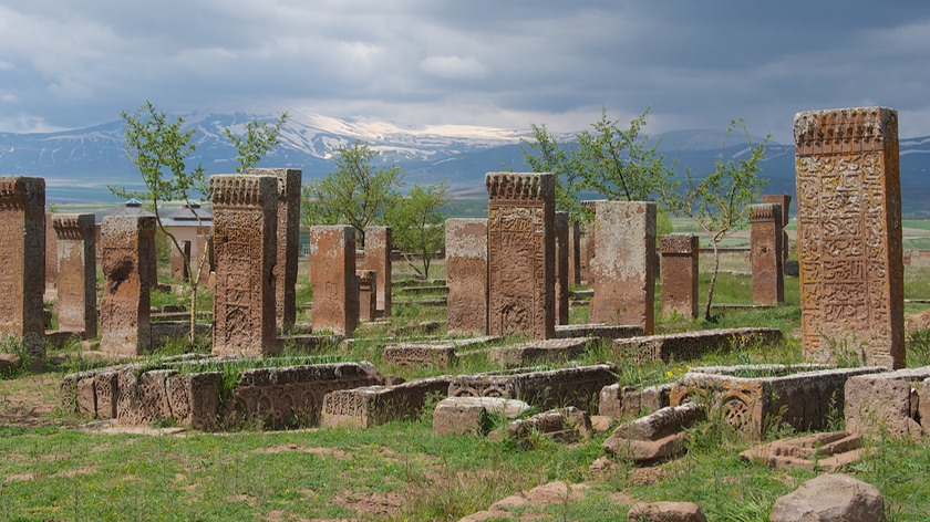
The cemetery was fascinating, and the setting, with the mountains behind, quite evocative. We poked around and traced the fancy inscriptions on the basalt stones, then ran for the small museum when it started to rain. Looking for shopping and a place for the night, we headed into Tatvan, where we found a home in a parking area, took care of chores (including filling several prescriptions at a local pharmacy – for very little money), and settled down to a big mountain thunderstorm; tomorrow is another day. This is definitely a lovely and interesting area to visit. The stores are now filled with apricots and melons, after a month or so of strawberries.
With the sun out again, we started around the southern part of the lake. We joined the main road through the region (D-300), which heads due east to Iran. The road is being worked on through a mountainous area, and for an hour or so was blocked while a mountain was made smaller. We entertained ourselves by showing the truck off to our fellow detainees, and Rick chatted up the construction guys. A good time was had by all, but we were happy to get back on the road again when the time came.
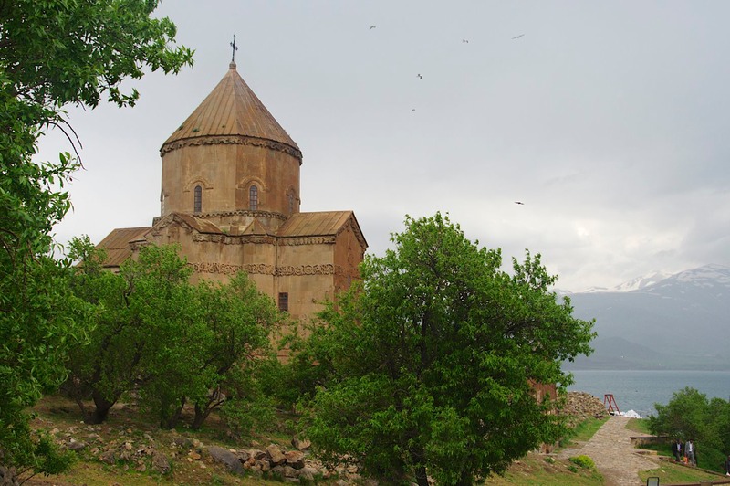
Our goal for the day was to take a ferry out to Akdamar Island, out in the lake, to visit the recently restored 10th century Armenian church there. The Armenian situation in Turkey is still tense (the 1915 genocide the basis of the problem), and the Turkish government has recently spent enormous sums in restoring this church, as a peace gesture. It is, indeed, spectacular.
We had to wait for a bit, until a sufficient number of folks gathered to make the trip worthwhile for the captain, and then headed out onto the water. Our visit was just great. The building is exquisite, the island small and easy to explore – and full of cemetery stones. Then it started to pour again so we ducked inside and enjoyed the interior of the church. In wandering, we met a couple of Ukrainian fellows, Sergei and Vasily from Odessa, who were really interesting to chat with. We ended up with a strong invitation to visit. May just have to do that!
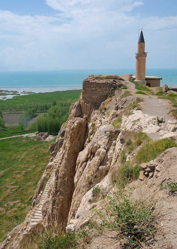
The next day we arrived in Van almost mid-day – and it was Friday. And where we wanted to go was right next to the huge mosque. Chaos. We did a discretion/valor right turn and got the hell out of town. We figured we’d come back another day (but never actually did; hmmm). We went over to visit the Kalesi (fortress), which was a bit of fun. It’s a remarkable set of fortifications that’s being extremely carefully restored. We clambered all over the walls and hiked up to the top for the views (quite fabulous) of the city and the lake. From the top of the fortress the Ottomans bombarded the Armenians below during World War I, almost totally destroying their old city and forcing them out of the area. Van has also been a hotbed of Kurdish stridency, although we didn’t see any evidence of problems.
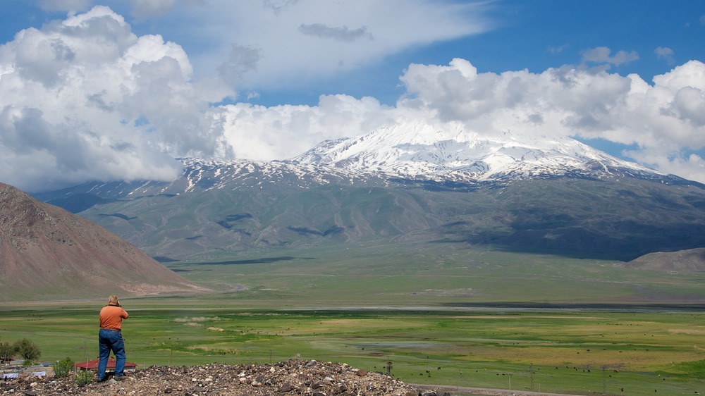
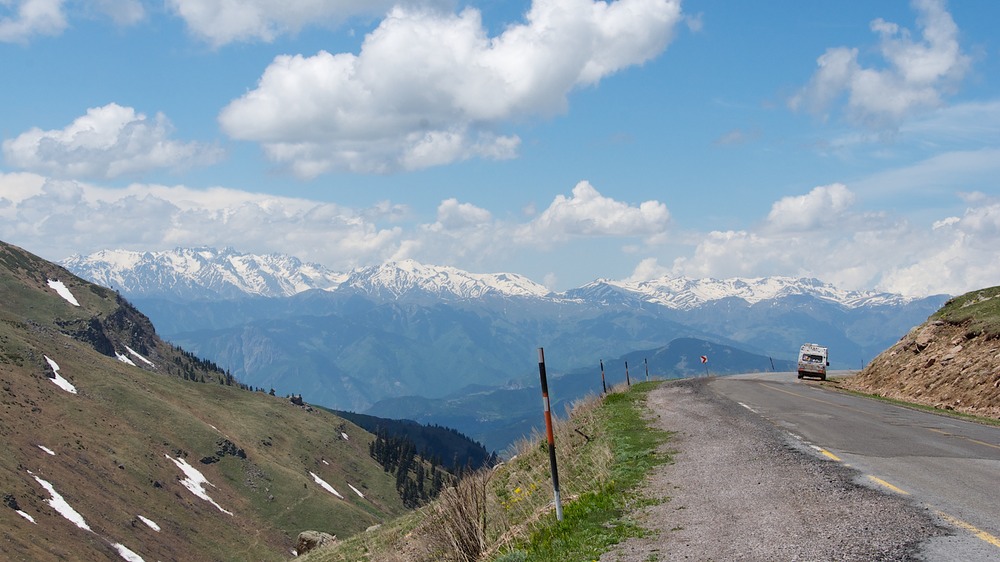
After our visit to the citadel, we decided to keep on moving, turning north now since we were almost all the way to Iran. We were on a road that would take us past Mt. Ararat (Ağri Daği), and the weather was bright and sunny, a good day for traveling past.
This is great country to wander in – very different from what we’d seen before. We were crossing the steppes, with wide, rocky expanses (sometimes cleared for crops), rough villages and small towns, and plenty of sheep and cattle. The towns were mostly rock, built into hillsides and low to the ground. We crossed a high pass (8541 feet) next to the border; we can see what appear to be guard posts along the ridge. Still no checkpoints. Soon after, we started to glimpse Mt. Ararat, of biblical fame, with its head in the clouds. What a magnificent mountain as you can see in the photo below with Rick in the foreground.
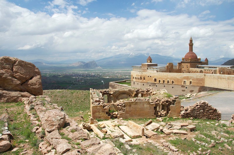
We came across this cool old fortified palace (Urartian/Selçuk), above the city of Doğubeyazit. It sits up on the mountain and is quite wonderful; we were told by a local fellow that it is the second largest palace in the country, after Topkapi Palace in Istanbul. On our way back down the hill we stopped to pick up a couple of hitchhiking women looking for a ride to the bus station. One Greek, one Iranian, both in their 30s, who had met on the internet. We had a great chat as we rode along. They were terrific and we hope to hear from them one day.
East of here, a short distance away, is the border forming the eastern edge of Turkey. In short order we pass within a few miles of first Iran (an open border, though not to us), then Azerbaijan (closed) and finally Armenia (also closed). A real international four-corners region. Fresh cherries are now at roadside stands.
Continuing north, we dropped down to about 3,000 feet (thank you – it’s warmer at night now) into a very dramatic and interesting geological area – a huge north-south valley cut by the Arpa Çayi (Ahuryan River). It’s green and lush and filled with orchards; quite lovely. For many miles, the river is the border between Armenia and Turkey, and much of the distance it is down in a deep gorge. This makes for great sites for cities, and we were heading for one of the most interesting – the Armenian ruins at Ani; in Turkey now, but historically in Armenia.
Our route to Ani was via a very small secondary road that turned to dirt (and mud after some heavy rains). At one point we stopped to consider, as we were about to start climbing up a quite steep and muddy hillside. Deciding this was not a good idea, we backed down and began to turn around, muttering about the many miles we would have to retrace, etc. etc. A man tending some cattle was watching us. He came over, shouted “Ani?” at us, and getting a positive response, urged us to keep on going as we were – don’t turn back, you’ll be fine was clearly written on his face. Apparently, if we’d gotten this far, the worst was over. So we carried on; and it turned out he was right; all was well.
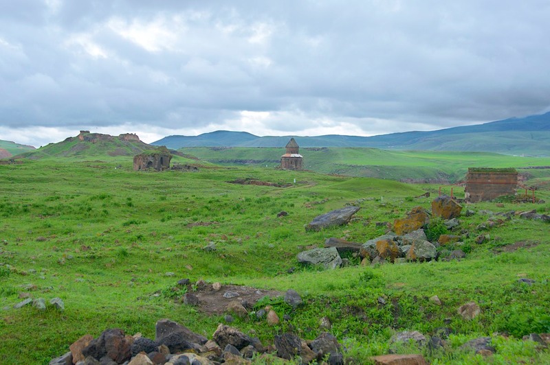
Ani was splendid; no, more than splendid. We had a great visit there. The rain continued, and the skies were brooding when not actually dumping on us; it all made for great atmosphere in this most atmospheric spot. The ruins go back to the fifth century, and are spread out over a large area that culminates on its eastern side at the gorge over the river. We wandered around, poking our heads into churches and fortresses, checking out the view over the river into Armenia on the other side and making note of the fence that ran along just below the edge of the bluff on the Turkish side. It must be hard for Armenia to look out its windows and see this splendid area which is part of its own heritage but is now just beyond its reach. There was plenty of military presence to make sure nobody got any ideas. We had the place mostly to ourselves, but did come across a group of high school kids on a field trip and just as we were leaving we chatted with a large group of college kids who had just arrived.
More rain that night and then we woke to bright sunshine. We had the truck washed, and then within 15 miles of getting back on the road ran into a construction project. Typical, but we were cool with it. The roads need the work and La Tortuga has a hard shell.
We passed a turn that we knew headed east to the border, but there was no mention of Armenia on the sign; this border is definitely sealed off. But there are other ways to get there, and we had decided we wanted to visit. So how do you get to Armenia? You go to Georgia first. So that’s what we would do. But we had a couple of other places to visit first; more on that later.
We traveled up the east side of Çıldır Gölü, the highest sizeable lake in Turkey. Supposedly it’s frozen 6 months out of the year; we saw lots of ice along the edges. We saw hawks and men on horseback and horses running loose. This is a very high, open area; the lake is at almost 6500 feet. The trees are just now greening up, and it looks a bit like Newfoundland. We saw an occasional herd of sheep, but it was mostly cattle in the area.
We topped the highest pass at 8659 feet and started down again; suddenly we were, once again, in a completely different terrain. Wow, this was a dramatic change. We had left Armenian Turkey’s high plains, and entered Georgian Turkey’s deep valleys. Over the next couple of days we made our way slowly to lower altitude, stopping to see two very intriguing old Georgian churches along the way. Just as further south we had been in areas that were once Armenian, where we were now all of this land once belonged to Georgia and there are a large number of old Georgian churches scattered around.
The Tbeti church ruins were delightful. We followed a splendidly rugged river gorge through Šavşat and then took a tiny turn up a tiny road to a tiny village. Suddenly we opened out into a pretty meadow and lush greenery, with some pretty terrific ruins to be explored.
Moving on the next morning, we continued following the river toward the Black Sea. The rushing river gorge we’d been enjoying for so long suddenly widened out, became deep green instead of white water, and ended in a huge dam. We’d reached civilization whether we wanted to or not. After stopping for directions, shortly before reaching the dam we turned up an even tinier and steeper and windy-er road to the small hamlet of Hamamli and its exotic church at Dolishane. This was perhaps the steepest road we’d ever been on. There was no signage, but if we learned it was a 25% grade we would not be surprised. We left the Tiger running to cool off after the climb while we poked around and took pictures of the ruins and the poppies in bloom and had a good time before slowly starting our first gear descent.
Just below the dam we reached the hillside city of Artvin and turned toward the coast about twenty-five miles away. We finally dropped down out of the mountains for good, after spending a couple of weeks above 5,000 feet, and found ourselves driving through lovely tea plantations as we once again arrived at the Black Sea.
We had originally intended to spend several more days in the Georgian area of Turkey; it has many treasures to be discovered. However, we have decided to visit the Caucasus Region first, and leave these remaining jewels for when we return to Turkey and start heading west again.
We are just across the border into Georgia, happily parked beside the Black Sea, spending time in the city of Batumi taking care of insurance issues, checking on visas, picking up mail, and happily discovering a few food items in the grocery store that have not been available in Turkey. The language is new (but some folks speak some English), the lettering totally different (and not even Cyrillic, which we recognize), wifi is back to going to McDonalds, the money weird, the drivers totally crazy; all the usual. And you know what else? We’ve entered into yet another time zone; we’re now eleven hours ahead of the west coast. But guess what? Diesel is less than $5.00/gallon and a brand new country awaits us. Awesome!!!
Rick and Kathy, signing off ‘til next time.
Click to see more photos from Eastern Turkey