November/December 2006
Dondé Estan Catalina y Ricardo?
Mexico truism: any 2-lane road is actually two lanes in each direction… at the discretion of the driver.
Last you heard, we were in Rapid City, getting out of town. We were headed for Mexico for the winter. And happy indeed, off we went, on October 21st. It was cold and snowing as we took off. We took a straight shot down the center of the country, heading due south from South Dakota through Nebraska, Colorado, the tip of the Oklahoma panhandle, and into Texas. Still very cold, but getting better.
We spent half a day in Amarillo, taking care of some maintenance (we’ve seen Amarillo from both sides now – still nothing good to report, but now we know Amarillo means “yellow” in Spanish), then beat feet for Lubbock and its oil pumps. This far south, the cotton and peanuts were still being harvested, and there were other crops in the fields as well, along with the oil wells. Lubbock is the home of Buddy Holly and Mac Davis, and a bumper sticker saying “Life’s too short not to live it as a Texan.” We’ve decided that Texas, like Vermont, is something of an alternative universe.
On beyond Odessa and the Permian Basin oil fields; the oil smells filled the air. Spent two nights in Pecos (at least they have good pizza) re-stowing the hold in our new little-er rig. Through Ft. Stockton (which we’ve decided has a badly depleted gene pool), and on to Big Bend National Park, our last U.S. destination for 2006.
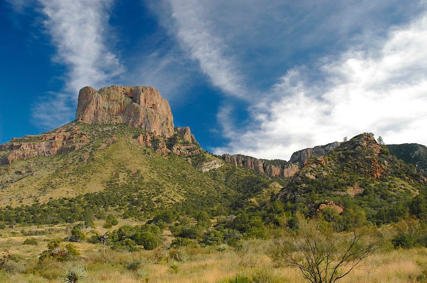
We like Big Bend, and it did not disappoint. This park is not for those who are looking for lots of creature comforts. There is little water available, it’s very rustic, and it is only mobbed during spring break, when all the hikers in Texas show up to climb the peaks. It’s a peaceful, beautiful and dramatic spot. Just coming through our campground we saw javalinas, a lovely red fox, several deer, and a splendid skunk that was very proud of its magnificent tail. We were camped in Chisos Basin, up around 4000 feet; for late October the weather was very pleasant, although cold at night; we spent several days. Then we traveled to Presidio (Persidio to the natives), where we picked up our mail and headed for the border, crossing into Chihuahua, Mexico.
Entering Mexico involves a certain amount of hesitation and concern. Will they have changed some regulation and not told us? Will we have the correct paperwork? Will Mexico for some reason decide they don’t want me to bring some of my food supplies across the border (we are very used to having “them” take things away when we come back into the States, but not going the other way)? Will we be able to understand what they ask?
Worries are always bigger than actualities. We did have a few anxious minutes because of a quirk in their regulations. But everyone was very pleasant, we figured out a solution, and within half an hour we had completed all our paperwork, had our passports stamped, and were on our way. YES! BACK IN MEXICO!
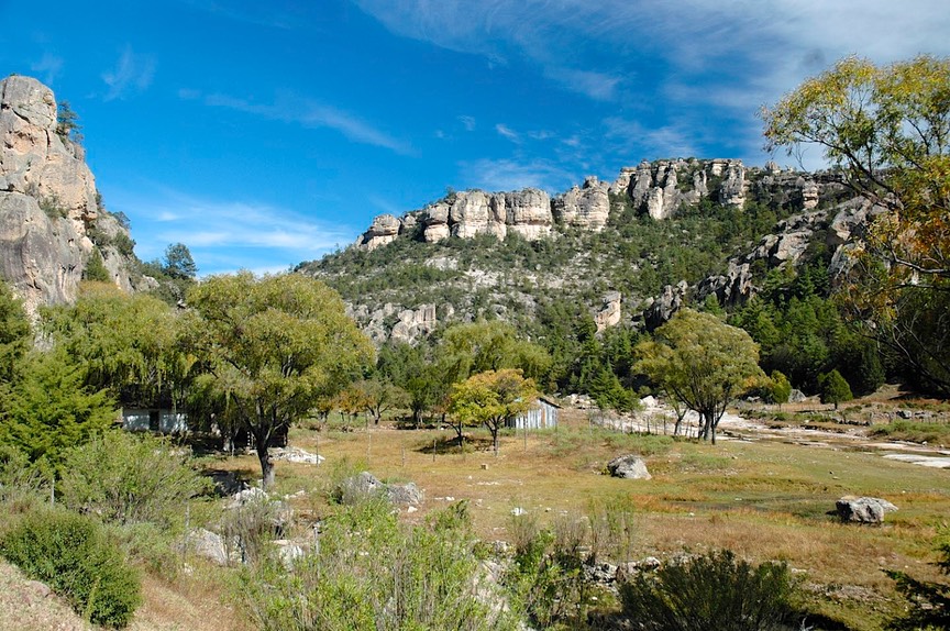
We started with relatively few definite plans. The State of Chihuahua is the home of the best apples in Mexico (yum), available along the side of the road. And also of the renowned Copper Canyon; we decided to start there. And this area has turned out to be the biggest highlight of the winter so far. We began our stay in Creel, on the edge of the canyon area. The “Copper Canyon” is actually a group of about 15 barrancas that go deep into the earth, deeper than the Grand Canyon. The area is very rugged and mostly inaccessible except by foot or mule. We explored the town of Creel, where the famous train stops before it heads down, down along the edge of one of the major canyons, and then on to the Coast.
We were in Creel for November 1st and 2nd, The Days of the Dead, a huge celebration in Mexico. The local cemetery was the focus of the activities on the 2nd. We had seen people buying huge wreaths to place on graves. Then they party. We heard music playing most of the day, people were singing and having picnic lunches, and spending the days visiting with and paying homage to the departed.
There is a large native population here, very shy and reclusive, many still living in caves down in the canyons. It seems tourism is bringing them “right along” I’m sad to say. We can only hope they will be able to retain their separate identity as time goes by.
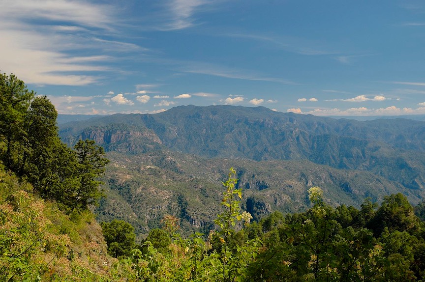
In leaving the area we took the only paved road down to the bottom and then up the other side. It was totally incredible. You drop down through several types of vegetation; at the top it’s dry desert, but down in the bottom it’s tropical vegetation. The rock formations are neat, it gets wetter and wetter, and it’s completely stunning.
We spent that night in the front yard of a rancho where they were preparing to ship cattle early the next morning (he was happy to have us but warned that they were going to be loading starting about 4:00 am). When we awoke we were surrounded by turkeys, chickens, and other barnyard critters, although we had slept right through the departure of the cattle. It was a very nice experience. The people moving the cattle were American, taking them to New Mexico, and we had a nice chat with the Mexican owners, using the Americans to help interpret. The rancher was quite gracious, offering us coffee in the morning, and wishing us well.
By now we were back up at desert level and were approaching Durango, of western movie fame. Several old movie sets are available for viewing, and John Wayne is revered here. We were unimpressed. We had come this way in order to avail ourselves of “the Devil’s Backbone”, a wild and wooly road over to the Pacific Coast. Mr. Toad’s Wild Ride has nuttin’ on this road! Many, many tight switchbacks; a climb up to over 9000 feet before dropping to sea level; crazy kids on motorcycles challenging this famous road; heavy traffic piling up behind the ancient, snail-like Mexican trucks, and the newer trucks piling up behind us until we could find a spot to move aside for them. It was a gas. We sure wished we’d brought the bike with us; we’d have enjoyed the road with those kids a lot.
After all the wiggles and squiggles, you drop back down into tropical vegetation and the lovely Pacific Coast just south of Mazatlan. Along the way you leave Chihuahua and enter the State of Sinaloa. Easy to spot: it’s where the road, which had been excellent, became garbage. Potholes are now added to the trucks, buses, cattle and horses, pigs being herded by small children, cars all trying to get there first.
But the coast was our goal. We decided that this year we were going to explore it and see why so many people arrive on the coast and never take a step any further. So we moved along down below Mazatlan, through the citrus and avocado groves. We spent a week camped right along the beach, in a small campground that even had a swimming pool. This was a blessing, because it was very hot -- in the 90’s – and quite humid. However, there were pelicans and frigates every morning, and dolphins passing by just off the shore, and the fog would come in at night and cool us off. We were in a wetlands area, and just a few yards inland the land was filled with low brush, palm trees, and gorgeous flowers and birds. In the mornings it was quite mysterious and strange until the heavy fog burned off. One morning we got up early enough to take some pictures before it cleared, and we got some great ones of big spiders in their huge webs.
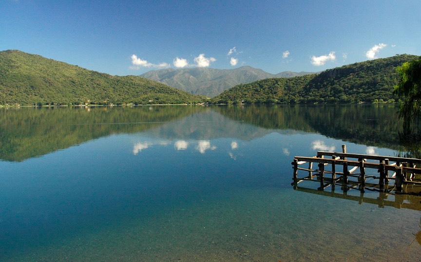
But it was too damn hot, so we headed for cooler, higher locations. We stopped for our first night beside a lake in the hollow core of an ancient volcano, a beautiful spot. This is a well known local resort spot, between Tepic and Guadalajara, near the famous tequila-producing area and town of Tequila itself. We spent some fun time talking to a couple of fellows from Colorado who were on an exciting motorcycle trip for about a month. Again, we whined at each other because our bike was freezing its tush off in South Dakota. These guys were having fun! We told them where we were headed, to Villa Corona outside Guadalajara, and they actually joined us there a few days later—more fun times.
Villa Corona is a great spot; we had spent a couple of weeks here last year, at a balneario (water park) with an attached campground. And it was just as much fun this time. Lots of pools of the local hot springs water, a town nearby to walk to, a good wi-fi spot, beautiful grounds to stroll in, and even a washing machine. But…….Villa Corona is also a REAL party town. We arrived in the middle of their fiesta---a 10 day celebration culminating on November 20th, the 96th anniversary of the huge 1910 Mexican revolution. Celebrating, Mexican style, involves activities in the plaza all day and night, with competing bands each evening and fireworks about 2:00 am. Oh, yes, and did we mention the firecrackers 24 hours a day! All huge fun, and the little kids marching in parades were quite wonderful (rats, forgot the camera). We bought a gorgeous cake from the pasteleria for Rick’s birthday (also on the 20th), and enjoyed all the doings. But after about a week we’d had enough of all this splendiferousness (and needed a good night’s sleep).
Also, we’d started getting messages that Kathy’s dad in California wasn’t doing too well. So we thought we’d head back toward the coast. If we needed to head out toward California we would be closer, and if not, we could continue working our way down the coast, now that it appeared to be cooling off some. We hated to leave this lovely sugar cane and blue agave (maguey – the source of tequila) area, and promised we’d come back for another visit if we could. But the coast is also very nice, and has its attractions.
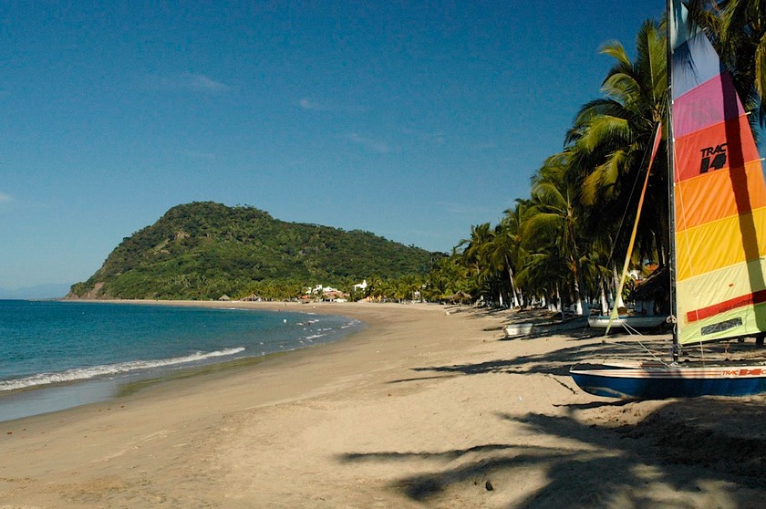
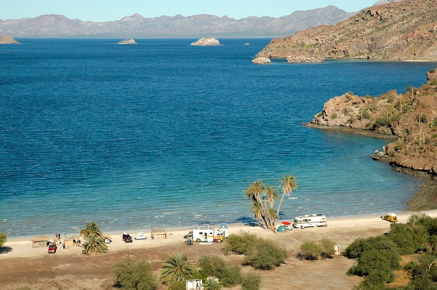
So we moved further down the coast, to a lovely spot north of Puerto Vallarta. We stayed in a little beach town, Lo de Marcos, along the most incredibly beautiful bay. When you think of a tropical beach, with palm trees, catamarans, palapa restaurants, warm waters and ocean breezes: this is it. A real paradise. But Dad was not well; so we headed north, back to California.
It took us five days to get to the Bay Area; we arrived just as he had been sent back to the hospital, and he died a few days later. We were able to have a few good moments with him before he started to drift away. Dad was 95 and had had a very good life; he simply died of old age, in no pain. It could not have been easier on him, or us.
We worked our way back down through the state of California, and decided that if we were going to head back into Mexico, it made sense to do so by way of the huge Baja Peninsula. The road up the mainland Pacific Coast had been rather boring and had led us back into the States by way of Nogales, Arizona. We had no interest in retracing our steps. If we went down the Baja, we could take a ferry boat back to the mainland, touching land at Mazatlan. We knew this was an expensive choice, having heard that the ferry was very pricy. But we didn’t like the alternatives.
People either love or hate the Baja. “It’s all desert.” “It’s wonderful free camping with nothing to do but enjoy yourself.” “It’s the last frontier.” “It’s a great place for off-road adventuring.” “It’s nothing but cactus.” It is all this and a lot more. Just as with the rest of Mexico, about the first 350 miles is pretty yucky. Poor people, pretty dirty, one huge border town sensibility. We kept on trucking, navigating our way through Ensenada, and wondering what kind of a mistake we had made.
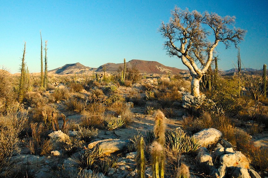
Then we got about halfway down the peninsula, below El Rosario, and suddenly it was very interesting. Rugged mountains; fascinating, different kinds of cactus; huge boulders and other kinds of rock formations; pretty churches in neat little towns with lots of personality – suddenly it seemed like a pretty cool place.
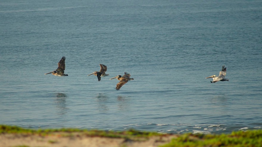
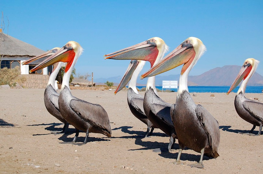
They say the “real” Baja starts here. Until 1973 the road stopped at El Rosario. Now it goes all the way down, but you can tell you are back in Mexico now; above here it’s just an extension of California, and not the best of that state, either. We meandered along, moving eastward toward the Sea of Cortes (also called the Gulf of California) and spent several days camping outside a small village along the Bahia de Los Angeles. Suddenly we felt we had arrived at our idea of the perfect “Baja” spot: lots of birds and dolphins, sandy beaches, a few interesting and friendly folks, great pictures to be taken, and our new favorite bird, the pelican.
Pelicans are incredible. They swoop along the edge of the surf fishing for breakfast. They dip and turn in tight formation, settling on the water by crashing to a halt and dropping very still, and despite a certain lack of elegance are surprisingly graceful. Some folks camping nearby went fishing in the mornings in their small boat. They would come back and clean their catch, and that totally mesmerized the pelicans. A huge crowd would gather, and they didn’t care how close we got as long as there was the possibility of any discards being tossed their way. You could practically sit on them. Between us we probably took 40 pictures of them – up close. It was really great.
After a few days of tranquility broken up by afternoon pelican photo-ops, we moved on down the peninsula. We needed fuel at one point, and had to wait in line for 25 minutes, reminding us of 1974. It was rumored that there was a gas shortage on the Baja, and if you found a station open you should take advantage and fill up. Christmas was rapidly approaching by now, and we suspected that people heading to see family might be creating some of the problem. While on the subject, we found it interesting that gas on the Baja was a little cheaper than on the mainland, despite the fact that it is controlled by the federal government. And further from the source! Who knows?
As mentioned, there are several interesting towns on the Baja. Probably the most unique is Santa Rosalia. It was settled by the French and has a church designed by Eiffel (of tower fame). The town made us think it is probably what Martinique looks like: lots of wooden buildings with verandas overhanging the street, date palms (yes, on the Baja!), and a justifiably famous French bakery.
But ultimately we feel the Baja was wasted on us. We don’t fish, we get very bored sunbathing, we aren’t off-road vehicle enthusiasts, and we both suspect kayaks might bring us to an untimely end. The Baja Peninsula is a paradise for people who like those kinds of things. So we were ready for the “adventure” of taking the ferry boat over to Mazatlan.
The ferry leaves from La Paz. La Paz is north of Cabo San Lucas and environs, by a couple hundred Ks (that’s kilometers to you non-Canadian folks). So, decision time. Do we go on down and look at Cabo, which we’ve had described to us as pretty barren and full of folks trying to get skin cancer? Or do we go on over to the ferry building and see what the deal is? If we have to wait a few days for a ferry (we’d been told it could be a week or more), perhaps we’d explore Cabo during the interim.
Lets go see what’s it going to cost and how long we’ll have to wait. Well, we got there, we could leave on the ferry that was taking off in about an hour, it would cost less than we’d anticipated, and well hell. So off we went.
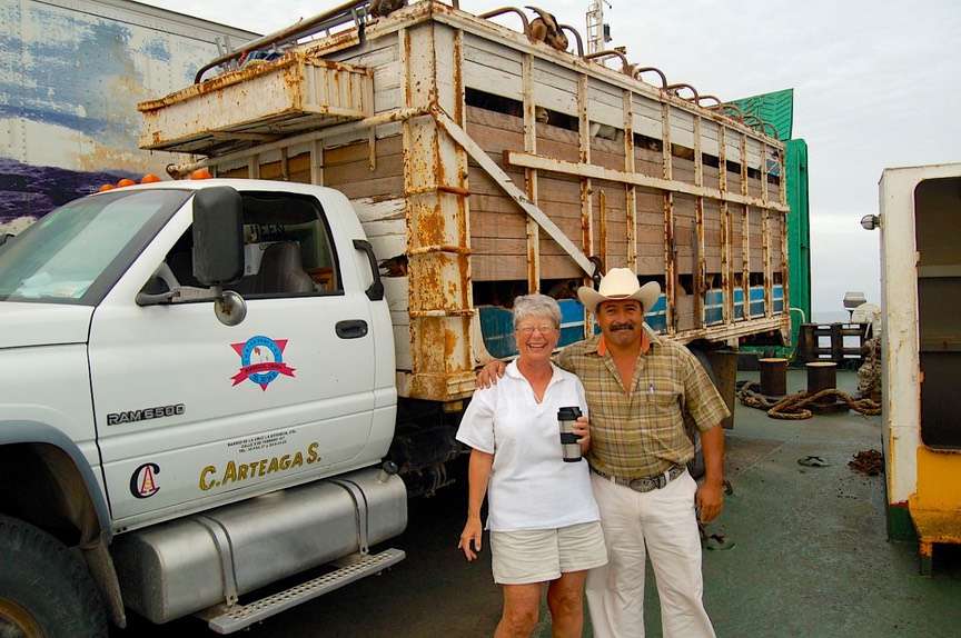
We were the next to last vehicle to be loaded, right in front of an open truck full of goats; we were assured they would be down wind. The voyage lasted about 16 hours, and it was pretty basic on that ferry. We have been spoiled by the Washington State and Canadian ferries we have taken over the years. This one was smelly, the stabilizers weren’t doing much (stabilizers?… HA!), the interior areas were smoky and murky, no cabins were available (good thing, we found they weren’t much), and food was pretty much nothing. But, we had checked before boarding to be sure we could stay in our own home on deck, so we slept in it and ate in it, and got by pretty well. We made friends with and had a great chat with the rancher transporting the goats (chivos) to Colima. So we did okay, but were ready to disembark when we pulled into Mazatlan.
We treated ourselves to a fancy breakfast before heading south once more, back to Lo de Marcos. We arrived a little more than a month after we had left. Friends were there, we enjoyed Christmas dinner with many friendly folks, and then, the day after Christmas, headed further south, to Puerto Vallarta, about an hour away.
And you know, we very quickly realized beach towns were not for us, either small or big. Puerto Vallarta was chock full of happy people celebrating their holidays, just chock full. Not for us. The traffic was yucky, it was hot, people were everywhere, an enormous cruise ship was moored in the harbor right smack in front of the Wal Mart; why were we here? We had planned to go further on down the coast if it suited us; but there were no penalties for not sticking with a plan (plan?... HA!).
So……what looks like fun? Oh, cool! We just happen to have a terrific alternative at hand! Last year we met some folks who had come in from the coast by way of a little town called San Sebastian, and really said it was a great trip. It had been pretty rugged, but they thought we could make it. They’d had to do part of it on dirt, because a new bridge was under construction, dropping down to a spot (to ford the stream the bridge was crossing), then back up the other side, threading their way among the construction trucks. Well come on; let’s see what it’s like. And it was great. The bridge is finished now, although they are still working on the approaches. We trundled along on this beautiful mountain road, passing several eco-tourism spots. It appears this area is gently being developed as a tourist destination. This is now an alternate route between Guadalajara and Puerto Vallarta, and probably explains the amount of traffic we encountered.
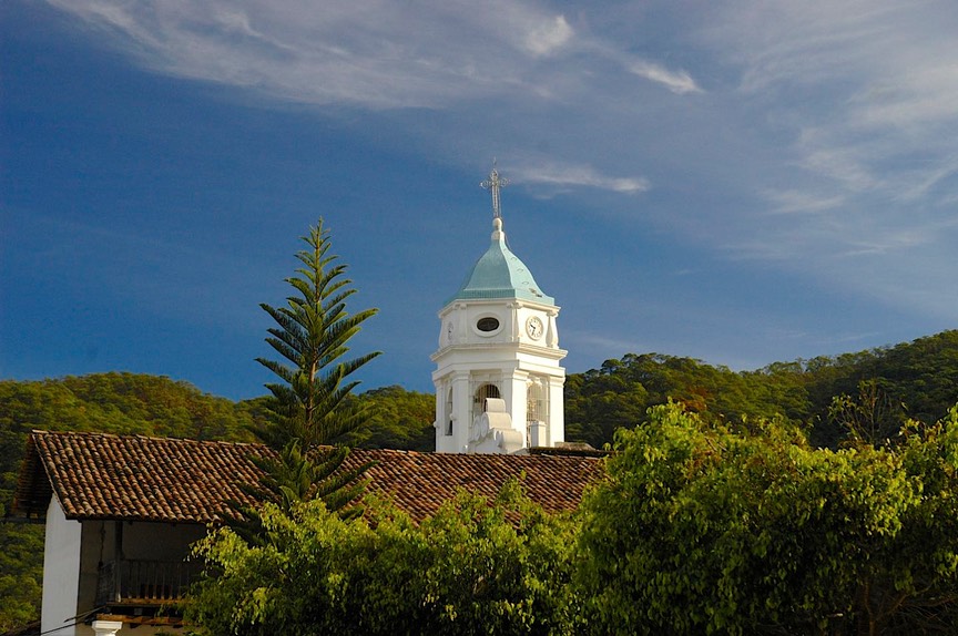
We ultimately reached the turn to San Sebastian, 5 miles up a steep dirt road; way off the beaten track. But we kept seeing lots of cars. Turns out San Sebastian is a very popular destination; there are artisans working there, the town is lovely and quaint, the air is clear, and it is a pretty countryside area. Unfortunately, we learned that the road is slated to be paved, and we suspect the town will become less quaint. We enjoyed our visit, staying the night (we slept along the central plaza, right next to the basketball court), and then trucking on around mid-morning, after taking zillions of pictures. We were happy the road was not yet paved.
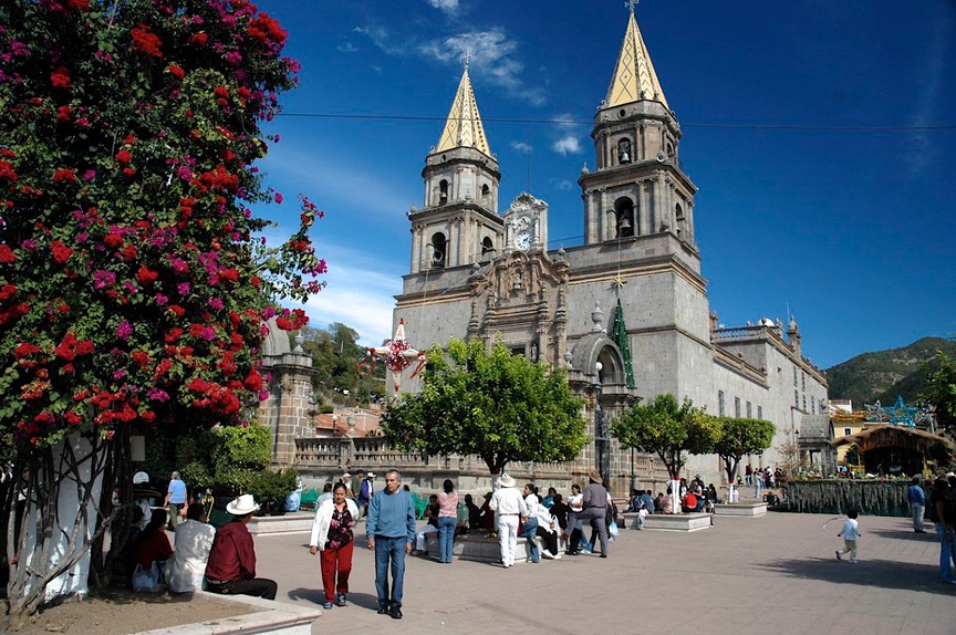
There are other quaint and lovely cities along this road, and we stopped to enjoy Talpa, which has a really interesting church. The square was very crowded with folks on holiday, and plenty of vendors. We bought some truly splendid watermelon, and watched the kids with their new Christmas toys. Virtually every 7-9 year old muchacho had a radio-controlled car he was sending between everybody’s legs – except those cars where the battery was already dead and they were leading them around with a string.
We ended up back in Villa Corona for a couple more days, meeting an extremely interesting Mexican couple who were relaxing for a few days before heading home to Guadalajara for New Years. She is American (from Indiana), and came to Mexico to work on a master’s degree 35 years ago. He is an attorney in Guadalajara (and we have his card now!); they were great to chat with. When we left Villa Corona they sent us off with directions to yet another charming town, Mazamitla, this one with a great place for lunch (it was, indeed).
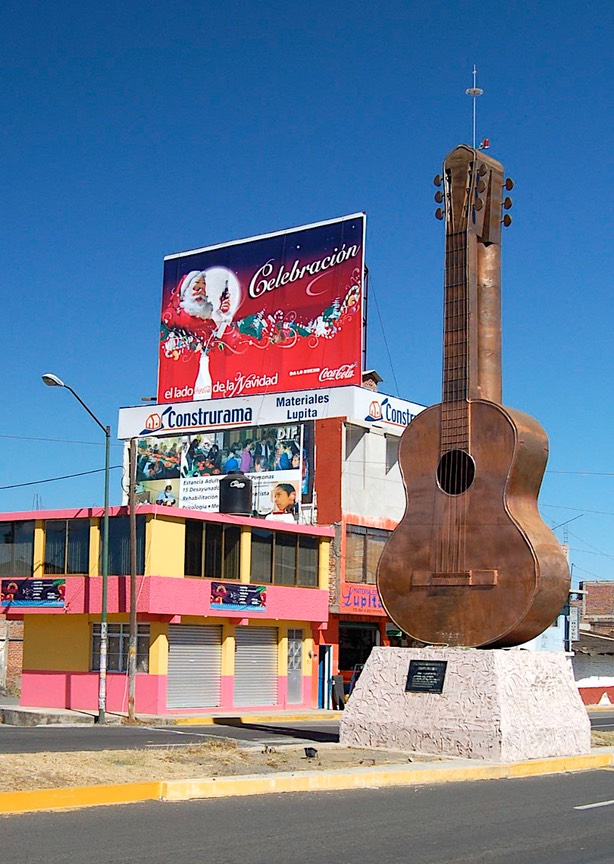
We suffer from (and are blessed by) the curse of wanting to stay off the beaten track. We are now in Patzcuaro. You can get to Patzcuaro from Villa Corona easily by going on major roads. Nice trip, too. But us? Not us. No, never. We go another way. And “going another way” is always fraught with possible difficulties. But we had wanted to stop in Paracho and visit the fellow who made Rick’s guitar. And we did, and it was fun. But it was preceded by a 1-1/2 hour period of time when we went 20 miles on a dirt road under construction. And we got lost a few times. The police finally helped us get out of Periban, leading us through many tiny little streets, past the square (again) and back to where we had missed our turn. They were really cute about it though, and didn’t seem to mind at all. We were the best entertainment of their day so far.
We have now settled here in Patzcuaro for a couple of weeks. What a delightful place! This year we’ve decided to take some language classes. We increasingly have a sense of being on the outside looking in, and want to be better connected with these wonderful people. So we are struggling to learn the basics of Mexican Spanish; it’s tough, after all these years, but we’re having a great time. It’s quite exhausting, but the teachers are cute (Edna and Alejandra) and we are actually learning things.
This country Mexico is beginning to feel very comfortable to us. After our first few days, spent reorienting our thinking and priorities, we have felt at home; this is a feeling of belonging, that Mexico is a good place to be, a place to come back to over and over again. This year we plan to be here until early March, when we will be heading toward the West Coast once again for a family wedding on St. Patrick’s Day. After that, who knows!
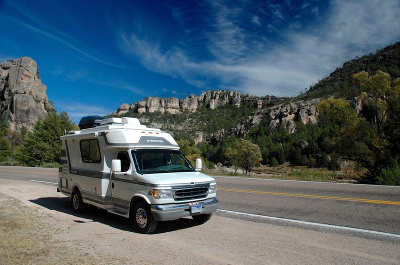
Happy Travels, Rick & Kathy with Patzy, our Chinook
Click here for more pictures from Mexico.