July/August 2016
High Plains Drifters
It’s All About the Roads out in the Mountain West
We were last seen muttering about heading for Laramie and then Rapid City. Two biggies on the western plains. We’ve now conquered both… along with a chance to see the Great Race pass by, in Lusk, Wyoming. Lusk? You don’t know where Lusk is? Silly, you go north out of Laramie, through the Laramie Mountains, to Douglas. You know Douglas, don’t you? Its town mascot is the Jackalope. Then you go due east for about 45 miles and (ta-da) you reach the small hamlet of Lusk, loneliest county seat in the loneliest state in America — Wyoming. We’re talking elbow room, folks! Wide open spaces.
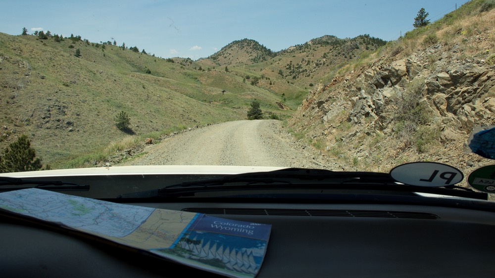
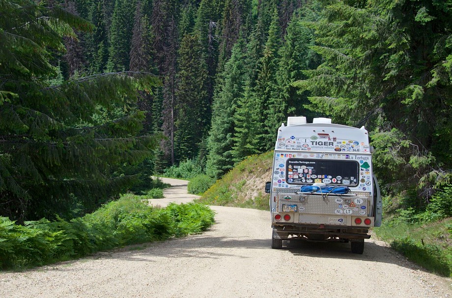
We had decided that this summer would be dedicated to back roads, both paved and dirt, through mountain forests and open grasslands. Along pretty streams that go through lovely meadows. Over high passes that still have snow on the ground (and campgrounds still closed in late June due to recent extreme weather), and past dusty dry places with little to recommend them. Along roads that pass between huge tracts of burned out forest — some long enough ago that the forest floor is starting to turn green again, but some still smelling of recent fire. Places where animals are abundant: antelope, squirrels, prairie dogs, deer, the occasional skunk, and even elk and moose. Why would anybody not want to travel in a four wheel drive…
* * * * * * * * *
So how did all this good stuff take place? High Plains Driftin' is the order of the day. Having finally crossed north out of Colorado and started east across southern Wyoming, we ended up in Laramie. For the uninitiated, Laramie is near Cheyenne. The Old West; cowboy country. We explored the Laramie Mountain Range that runs north from there to Casper — no paved roads through the whole area, and we had it all to ourselves: lovely open valleys with rocky peaks and huge boulders, and our best elk sighting. We emerged at Douglas, where we crossed the Platte River for the first of several times. Really nice country. Spent one night almost directly underneath a natural bridge outside of town; it’s in their county park — not as big as the National Park in Utah, but even prettier, and much greener.
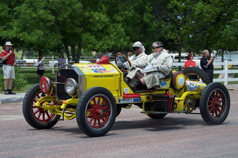
After we arrived in Douglas, we suddenly heard that the Great Race would be passing nearby the very next day! Well, we found ourselves on our way over to Lusk, where this big bunch of old cars and their drivers would be stopping for lunch on their way to Rapid City. Hot? Yeah, but worth it. The old cars streamed through for about two hours, arriving in small bunches, being timed in by the organizers and then parking while the crew members went inside a cafeteria for lunch. Lots of great cars from 1972 and earlier; you’ll want to go to our Great Race photo page to see the pictures.
We finally finished horsing around with drivers and fellow enthusiasts, and moved on, heading for the hills — the Black Hills of South Dakota. We had friends to see in Rapid City, and a little Tiger business to attend to. We spent a few days wandering in the Hills, on the forest service back roads, parking for the night in meadows filled with white daisies. Deer wandered by, stopping to stare for a bit, then wandered on. One afternoon a small herd of cows came along. We were actually parked in the middle of “their” road and apparently were in their way. After a bit of mooing and huffing, they made their way past us by going further up the hill a ways. This was a busy and beautiful late June weekend, but in terms of people we were all alone with nary a McDonald’s or a water slide in view. Reminded us once again of the value of going places where other folks don’t. Finally, reluctantly, we gave up our meadow and wandered down into Rapid, getting stuff done and having a giggle with our good friends there.
But the wilds were calling, so we turned our noses toward the setting sun, starting our journey back to the West Coast. We had not visited Mt Rushmore, the Badlands, Deadwood, Crazy Horse, or the bison herds; all sights we’d seen before. Ah, but the wildflowers! Spearfish Canyon! And the aspen trees were glorious; we do like the Black Hills.
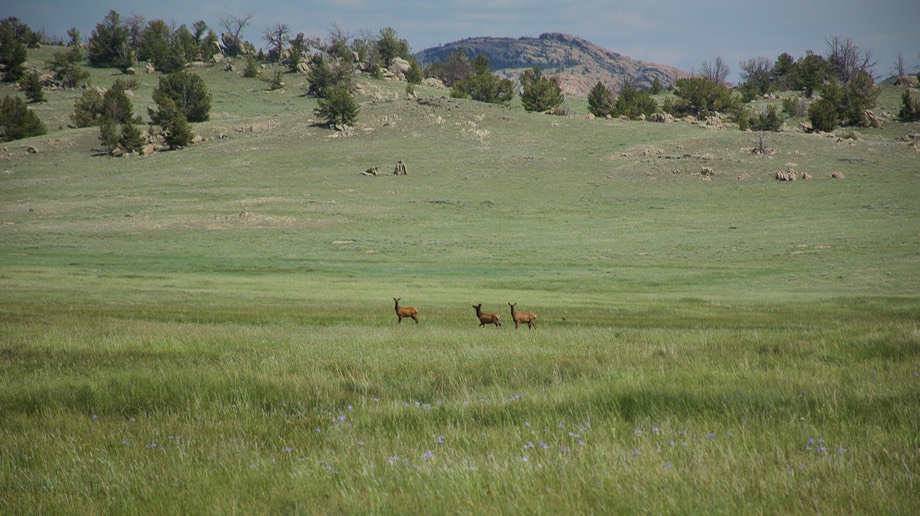
Before detouring off to Lusk, we had intended to explore the Thunder Basin National Grasslands, in northeastern Wyoming, so we headed there now. Fields of grass, you say. Well, some. But much of what we were seeing was sage and other low grasses, prime country for the pronghorn antelope - not technically an antelope we learned, but called that just the same. They are native to North America and two thirds of them live in Wyoming. And we saw lots of them. One night was spent parked in an open field. It turned out to be a well traveled area, by both antelope and deer. They would come over the rise, see us right in the way, stop for a bit, then slowly move along, coming close to the Tiger as they kept going. We kept inside the truck, so as not to scare them off. It was like being in a deer hide. We were able to take pictures without disturbing them and had a great time. (Did I mention the prairie dogs? Oh, and the jack rabbits? Multitudinous.)
On a small road through the park we took a crossing of the Cheyenne River; the landscape was low hills, sage, and critters. We had the road to ourselves. We saw two young bucks, each with a small rack, perhaps their first; the camera was elsewhere, of course. When we left the area, the smell of sage stayed with us for days.
Hating to leave the park, but knowing we had a time frame to keep in mind, we went on to Lander, where we enjoyed the town’s 4th of July celebrations (fireworks day and night), spending the holiday camping at their county park. It’s still very hot. We need to get up into the nearby mountains.
Soon we started to climb, up to Dubois (the locals say Dew-Boys, I’m afraid). We knew there was a dirt road up over the Continental Divide just a bit north and west of town, and we figured it would be cooler there. So after stopping a bit at the fantastic National Bighorn Sheep Center, we moseyed on up the hill. Shortly we came to FR 263, aka Union Road, and hung a left onto the dirt, entering the Shoshone National Forest. Up, up, up it went, to the top of the Divide, where we spent the night. Beautiful, open meadow at 9200 feet; it got down to 26 degrees overnight. Now that’s cooler!
We could have stayed longer, but we had friends we’d made plans with, so the next day we trundled on. Interestingly, shortly after crossing the pass we left the Shoshone NF and entered the Teton NF; territorial dispute perhaps. It all looked the same to us — gorgeous.
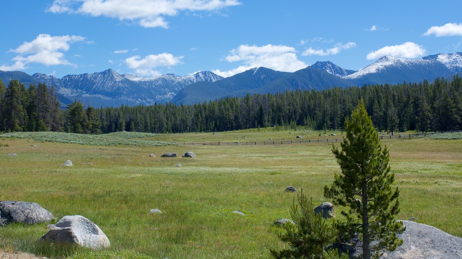
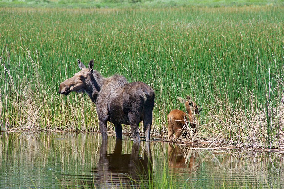
We dropped down to the edge of the Green River Lakes Wilderness area, a lovely region that follows the Green River for some distance. And along the way we were delighted to come upon a moose with baby, sloshing around in the river. Traditionally, there are no roads in national wilderness areas, so ours stopped at Green Rivers Lake, a pretty spot with a campground and boat launch. The campground was pretty busy, so we settled ourselves up a narrow road in the nearby forest, with only a deer for company. We think she slept in the grass near the truck.
The next day we eventually dropped down off the pass far enough that we found pavement, and more folks enjoying the river area. This is a beautiful spot, centered north of the town of Pinedale, and not too far away from the resort area of Jackson, in the same mountain range. We had to skirt around the town of Jackson the next day, on our way into Montana, next on our tour of the West. We probably didn’t see the area at its best. It being a Friday afternoon, the traffic jam was enormous. We were reminded of why we’d been dodging resort towns and well known areas all summer long. Jackson is a splendid place to visit, we know this; we’ve enjoyed it before. But not in July.
We kept moving, skirting west of The Tetons and Yellowstone (even more people, we knew), and driving through Island Park, Idaho with its “Longest Main Street in America.” After crossing the Continental Divide one more time, at Reynolds Pass (6836 feet — we were losing altitude!), we eventually ended up a couple of days later in the cowboy town of Ennis, Montana. Now this was kind of a journey to Mecca for us. We’d been in Ennis before, many years back (at least 10 years, Rick thinks). We had eaten pizza there that was so good I never had any trouble remembering the name of the restaurant: the Madison River Pizzeria and Bakery. After driving right up to the door we paused and went HUMPH. It was now a cute little picnic basket type place. FRUMPH. We drove around town, to see if it had moved. More HUMPH and FRUMPH and even BUMMER. Finally I started asking around. Found out it had disappeared long since, and no one knew where it had gone. Our loss. We did find excellent pizza — at the bowling alley for Pete’s sake!
Recovering from our pizza search, we found ourselves spending a couple of days out on open ground again (where are the trees we said — we are in western Montana, ya know) parked beside the Ruby Reservoir (supposedly with garnets available for the picking along the shoreline — didn’t see any) south of Sheridan MT (no, not the one in WY). Pleasant and quiet, and on the edge of yet another dirt road opportunity… groovy. It was the back road into Dillon. It rained during the night, and we saw fresh snow on the Tetons in the morning. Mind you, this is early July.
Starting south around the bottom of the reservoir, we soon found our dirt road, which was mostly mud. Hmm. Yes, we’d had (more than) a bit of rain the day before. So? Are we good here? Of course we are! So on we went, slipping and sliding here and there, up to the top of the pass at 7950 feet, where the temperature had dropped to 45 degrees. Definitely different. The road up to the summit had been about 20 miles of tight and winding adventure, but after reaching the top we soon found ourselves in a new environment. The road was still dirt, but there was an ongoing grading project underway — a really nice grading project I might add. The road was in super condition; and very wide. Why, we wondered? Because we were now approaching the Treasure Mine, a huge (at least to us) open-pit mining operation. Rick figured it was a better road because it had to handle all the trucks and personnel and such, and they were all coming in from Dillon, further west.
We’d never been this close to a big site under “cultivation.” It was interesting, if quite ugly. We took a gander, but kept on, down the hill and on into Dillon. Which is nothing much, I can assure you although we did find a pretty good lunch at 4 B’s restaurant.
By now, we were moving towards Hamilton MT, where some new friends were waiting to be met. From Dillon you can go a couple of ways. We chose a delightful back road, FR73, the Pioneer Mountain Scenic Byway, up as far as the town of River Wise. It’s paved (all the way, I think; but maybe a teeny bit of dirt road) and wanders through lovely forest. There’s lupine scattered over the forest floor, lots of pull-offs for views/picnics etc, and several delicious forest service campgrounds scattered along the creeks that flow through the area. A real find. We spent the night at one of the campgrounds, with deer and chipmunks (oh, I’d forgotten them earlier) around, sunshine filtering through the trees, and all the other good things you want out in the woods. We were so pleased we’d taken this road.
We finally rejoined the regular highway, then meandered through part of Beaverhead-Deerlodge NF, pulling off at one of the prettiest view areas we’d ever enjoyed. This was a prelude to heading up over the Continental Divide yet again for the eleventh (and final) time this year. We will stay west of the CD for the rest of 2016; now if we can just stop bouncing back and forth between Pacific and Mountain time all will be well.
A digression: anyone out there not familiar with the Continental Divide? It is a series of (mostly) mountains that splits the watersheds of the Americas into two parts; all waters west of the Divide flow into the Pacific Ocean; all those to the east eventually flow into the Atlantic or the Gulf of Mexico. In the US and Canada it mainly runs along and through the Rocky Mountains; in South America the Andes take over. Oversimplified, but probably a sufficient geography lesson for today.
One last pass over dirt roads — the Skalkah Pass in the Bitterroot NF — and we dropped down to Hamilton for a couple of nice days of rest and regrouping while visiting with some great new friends — friends of other friends and fellow travelers. This was followed by a brief “city fix” by going up to Missoula to visit some Big Box stores.
While in Missoula, we enjoyed a fun moment when a young couple in a pickup truck came up alongside us in traffic honking and waving and holding up a cell phone photo of Rick. After just a moment the realization hit us that they’d gotten the picture from our homepage. It was great fun and we later got an email from them explaining that they’d seen all the stickers on the Tiger and had gone to our site to see who we were, etc. We exchanged messages and have added them to our contact list. Neat. This was actually the second such occurrence for us recently. The day after we’d left Laramie, we’d gotten an email from a college professor in town. He had seen the Tiger, parked while we were having lunch, but had been short on time and unable to stop for a visit. It seems that he and his wife have been following our travels for several years and he’d been amazed to come across La Tortuga right there in Laramie. Despite mutual good intentions over the next week or so we were unable to hook up with them.
Moving on from Missoula (it was much too hot for one thing), we headed southwest over Lolo Pass into Idaho. Lolo Pass (US Highway 12) has always been a real favorite of ours: a nice trip through forests on a lovely, gently winding road that is a real treat. But, hmmm. We’ve always done it on a motorcycle, and those twists are the best part of the trip. In a truck it’s not as much fun, sadly, though still very pretty. It’s a well known road among moto types with a famous sign warning of “winding road next 77 miles”.
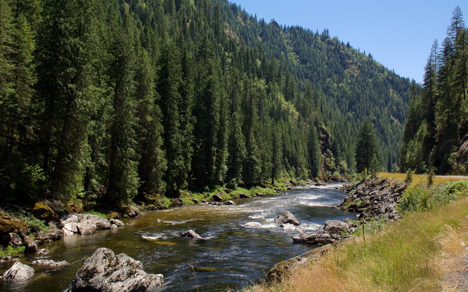
The map was showing us a nice area to explore east of Kooskia (Kooskia? who? where? what?), so we turned in at Lowell, heading for the Magreeder area across the mountains. But, mutter-mutter, the nice lady at the Public Lands office told us the Magreeder road was closed, probably permanently, as it goes through a wilderness area, which typically precludes wheeled travel (see above). So we detoured for several days through the forests of Idaho, following the South Fork of the Clearwater west to Grangeville — a beautiful and delightful ride through pristine forests with no one within shouting distance. Heavenly.
We picked up the Salmon River and followed it south along the Palouse Hills east of Hells Canyon. This is an old stomping ground for Kathy, who spent a zillion years at Washington State University in Pullman. During the day we passed a sign saying we’d crossed the 45th Parallel, marking the half way point between the Equator and the North Pole.
The prairie dogs had become ground squirrels. We were now moving a bit east, towards Ketchum and Sun Valley and Hailey, all still in Idaho. Sometimes on pavement, often on dirt and gravel. We cut through an area near a reservoir and suddenly had traffic as folks were heading either toward or back, all with boats being towed behind. We decided the heavier traffic was because another road in the area was closed due to fire.
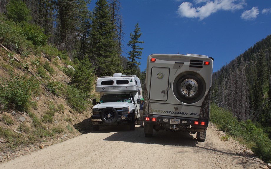
Then suddenly we went around a corner and — there was a white truck heading toward us; Rick said oh look, an Earthroamer… and there were our dear friends Rob and Nina Blackwell! Who Knew ?? What’re the odds???? R&N are Australian friends we’d last seen at Overland Expo in May (and prior to that in Iceland last year), but hadn’t a clue as to what they’d been doing since. And here they were an a dusty and rather rough dirt road near, well not really near anywhere, in back country Idaho.
So we sat blocking the road (fortunately the traffic had died down) and chatted for awhile, catching up on the news and taking a few pictures to commemorate the occasion. We then waved good-by and parted company until the next wild chance meeting. What a hoot!
Shaking our heads, we continued on towards Stanley, our next destination. There we could take on water, pursue a highly recommended pastry shop (Stanley Bake Company) and presumably be able to access the internet, for the first time in several days. All happened, just as planned. One bummer: we were going down to Hailey later in the day to visit friends there, but new email told us they’d had a death in the family and had had to leave town. We were sad for them, and very sorry to miss the visit. Good people whom we don’t see often enough and never know when our next chance will come.
Ah, well. We’d explore more of the area instead. We decided to make a big triangle run down to Sun Valley (past the headwaters of the River of No Return); over Trail Creek Summit; then up to Challis, where we’d pick up the Custer Motorway back to Stanley before heading down along the Sawtooth Range toward Boise. The Trail Creek road was great, and we spent a night in a deserted campground at the top, next to an open meadow with a creek running through it - and more lovely deer. After that it went downhill pretty rapidly, both figuratively and literally. The Custer Motorway was hot and very, very dusty; then, when we stopped back in Stanley hoping for a return visit to the Bake Company, it had already closed for the day. Rats-a-rooni.
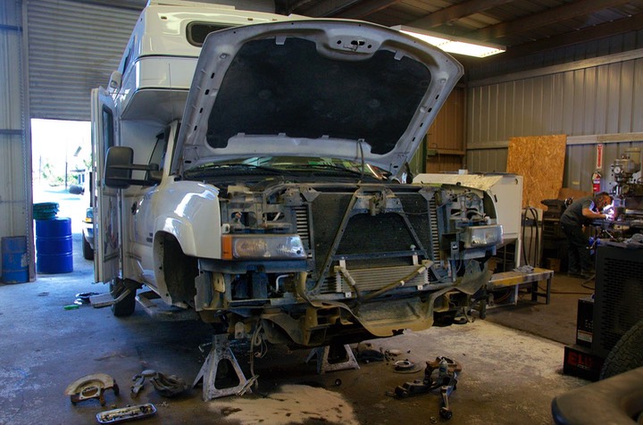
We stopped for the night not far west of Stanley and spent the evening reviewing where we were and what we were up to. It was time to sort out a few things. We were now heading toward southern Oregon. We had an appointment with a welder on July 25. This was the first of several projects that would keep us in the Grants Pass area for most of the next month, including preparation work to the truck that was scheduled to take 2-3 weeks.
Among the issues was the fact that we were going to have to find a place to live during those 2-3 weeks, as well as some wheels to get around in. (The first issue was solved by a very dear friend who has gifted us with the use of her home in Eugene, a couple of hours north of Grants Pass. She is away traveling until late in the month, and is happy to have someone keeping an eye on things — and watering her pots of lavender and bamboo. We are there now.)
As to the second question, we could either rent a car for the several weeks we’d be without the Tiger, or go pick up our own car and bring it along. The direct route from Stanley, Idaho to Grants Pass, Oregon goes to Boise, then across the bottom of Oregon to the Grants Pass area. But if we wanted to make changes in that plan, right now was the time to do it. Ultimately, what made the most sense to us was to make a detour to California, where our car was being stored (don’t ask.…) We had just enough time to make it work if we didn’t mind driving an extra 1,000 miles or so.
We stayed on our former route as far as Boise, following the South Fork of the Payette River along the quintessential mountain road that followed the perfect mountain stream, past a fire still being brought under control, and into the state capital, where we made a store run and then beat feet. We thus began a 2-day dash to Paso Robles, picked up the car (making time for both a lovely meal at Nardonne’s Pizza and a quick visit to our favorite barber), and then another 2-day run up over the Siskiyou Mountains into Oregon. Pant, pant; but we made it and even got there in time to go see “La Cage Aux Folles" at a local playhouse with our friends in Central Point. Not too shabby.
So here we are in Oregon, probably until at least the middle of the month. And we are enjoying ourselves. The welding job went off without a hitch (actually we didn’t need to change the hitch at all… ha, ha), and the Tiger is now all torn apart at a diesel specialist shop with lots of cool projects underway and a pile of new parts stacked on a table awaiting installation (more on that later). You can go to 2016 Tiger Refit 2 for a full report on the work we had done in Grants Pass.
Best of all? We had a really great six weeks in the wilds of the mountains and high plains of Wyoming and Idaho. We saw some friends, old and new, but the trip really was All About the Roads. Many of them gravel or dirt; tight, narrow, steep, twisty, dusty and muddy. Beautiful, alongside forests, streams, meadows and mountains. High passes. Up and down again and again, following these enticing little roads off into the distance. There were plenty of fun road signs: Cattle on Road; Watch for Rock (Rock who?); Open Range; Attention Firewood Cutters. Plenty of neat critters, and mostly blue skies.
We’d let La Tortuga out to play in the fields and among the trees and were reminded once again why we love him so much. There was no one around apart from the occasional fisherman fly-casting while standing in the cold water of the stream that was meandering through the nearby meadow.
We wanted to stay forever.
But for now? So Long from the Cannabis Capital of southern Oregon (it’s legal here now), we’ll be back in touch soon.
Rick, Kathy and LT, who seems happy to be the center of so much attention despite having pieces of Tiger strewn about.
Click here to go to our Summer in the US photo page