August/September 2007
Fall Colors & First Snows
Alaska, Yukon Territory, British Colombia
What a difference a new perspective makes!
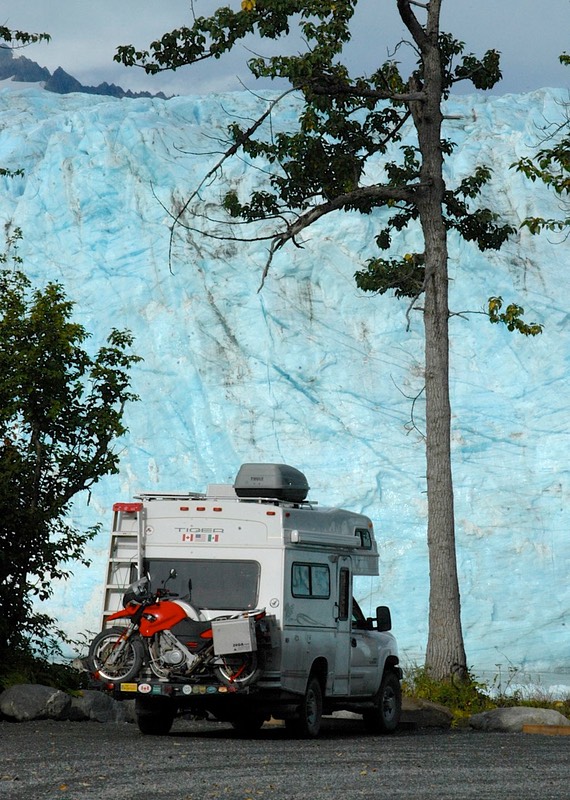
Two years ago we made our first trip to the far north, exploring some of Yukon and Alaska. At the time we decided Alaska was somewhat over-rated, with too many folks on too few roads and vast distances between sights worth seeing. We don’t feel that way any longer, not by a long shot. Alaska has tremendous opportunities to get off the main roads, see splendid countryside at your own pace, and discover “your Alaska”, and on this trip we were able to do a much better job of accomplishing that mission. In ’05 we were traveling in our 34’ diesel motorhome, while this year we were in our new 19’ four wheel drive Tiger! What a difference. We are extremely glad we returned; it was a grand adventure. All told, we spent over 5 weeks in-state, finally being driven out by approaching winter.
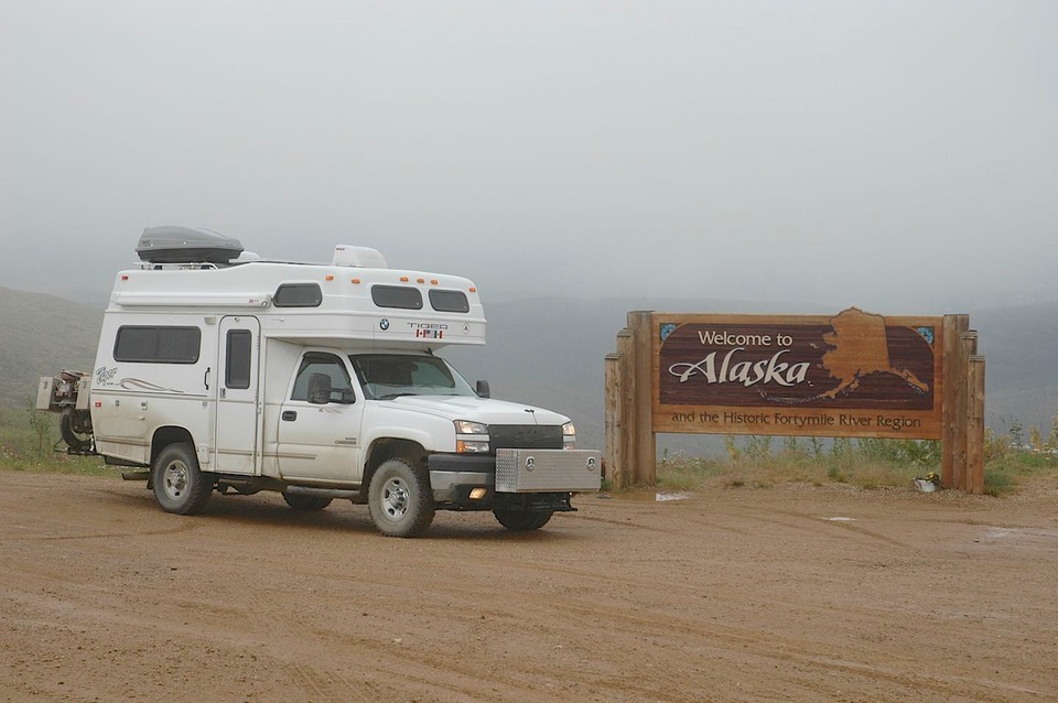
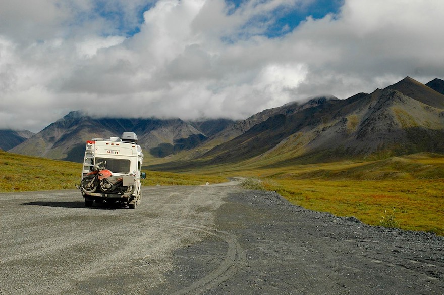
All roads into Alaska go through Tok. Not exactly a garden spot, Tok has fuel, groceries, good food, cool things to buy, and a place to wash your rig after the rigors of getting there. By the time we left Alaska for good, we would come through Tok a total of 4 different times, but that’s a series of stories you must await (bated breath, here we come). To get to Tok, you either turn left at Whitehorse, Yukon, and come in by paved road, or you go north, visit Dawson City, and come over the Taylor (Top-of-the-World) Highway and Chicken (reputedly so named because no one present could spell the far more common Ptarmigan). If you’ve been paying any attention, you know we’ve visited Dawson twice, so ta-da: we came in via Chicken. The Taylor Hwy is through beautiful country, some of it is paved, and it passes through barren lands similar to those we had enjoyed so much on the Dempster Highway up to Inuvik. We crossed right after a series of rains, in and out of clouds; at about 4000 feet we stopped for the night. We were above tree line and it was very stark and beautiful. At 4368 feet, the highest point, you prepare to cross back into the States from Canada. This is, possibly, the most peaceful U.S./Canadian border crossing anywhere these days; the guards are even friendly. It is the northernmost land border crossing in the United States.
And then you are in Alaska. And the road goes to hell. Alaska treats their dirt roads like, well…..dirt. Canadian unpaved roads are major roadways; we suspect this is why they are usually in very good condition. Alaska seems to hold their dirt roads in somewhat lower esteem, not worth the cost of good maintenance. Yeah, they say, but the permafrost ruins whatever we do. Do they think Yukon has no permafrost? Hah! But enough.
At the top of the Taylor Hwy is the road to Eagle, dirt also, that goes further north and drops down to this cute little town on the edge of the Yukon River. They are working on this road, of course, and there is little traffic. But we wanted to see Eagle, so off we went. It’s about a 60-mile drive, during 23 miles of which we followed a pilot car. BORING. But we survived, spent a pretty afternoon-evening in Eagle, stayed the night in a lovely BLM campground in a grove of birch trees (or were they aspens? …..or poplars? ….hell, who knows – deciduous trees with white trunks and pretty leaves), communed with the The River the next morning, and prepared to move on. While in Eagle, however, we had a life-changing experience. We ran into a fellow who was driving tour busses for the summer, and chatted with him about our trip up the Dempster Highway and other adventures. And he said “You must go up the haul road in Alaska, to Prudhoe Bay.” And then he whispered those three little words into Rick’s ear: moose, caribou, musk oxen. So screech, another abrupt turn, and we decided to fit Prudhoe Bay into our plans, meaning we would also be visiting Fairbanks, a pleasant idea in itself; and of necessity seeing much more of Alaska than we had originally intended.
But first we had to get out of Eagle. This time, we had to WAIT almost 2 hours for the pilot car (hell of a way to run an airline), and then follow the previous day’s drill, before we could really get underway. But we had a nice chat with the lady with the STOP/SLOW sign while we waited. Caribou season had just opened and she was hoping to get out over the weekend and bag hers for the year. We didn’t share our views on sport hunting with her. The season was just opening for lots of other critters as well as caribou, and hunters were everywhere. We are a definite minority up here, and have learned to just be silent on the subject. We continued to see hunters all over Alaska.
After finally getting rid of the pilot car, we got about 5 miles further down the road back to the main highway when we ran into another new adventure, at least for us. There was a woman standing beside the road, just after you cross a big river, hitchhiking. Now we don’t pick up hitchhikers – never. But we stopped for lunch in the area, and both she and her husband (and very friendly dog) came over, and we all talked. They had been canoeing on the river for 4 days, and had come out of the water there at the bridge. Their car was near Tok; one of them needed to get to the car and come back for the rest. We decided we’d better help out. We knew, because of the road construction behind us, that no cars would be coming along for at least 2 more hours and that traffic was extremely light in any case. So Paula came with us, leaving husband Dave, Daisy the dog, the canoe and their other stuff to wait for her return. Paula was delightful, VERY happy to be off the river and in civilized surroundings again, and had interesting tales to tell. They had been mostly alone on the river (their first try at this kind of stuff), but had hooked up with an old guy one evening, about the same time they ran into the bear. The old guy had a gun, and shot at it from time to time, which only somewhat dissuaded the beast. As I say, she was happy to be back on land. We dropped her off at her truck, shared hugs, wished her well, and went on our way.
After stopping in Tok (visit #1) for the night (baths for vehicles, hamburgers for people) we worked on connecting with our mail. It was about 140 miles away, down in Glenallen. We had thought that would be a great choice, because that had been our next destination after Tok; but now we were going to Fairbanks, nowhere near Glenallen. So we went down on the bike, picked up the mail, trucked back to Tok (redux numero uno), and hence to Fairbanks. We stopped in Fairbanks very briefly, and then started up the Dalton Highway (the Haul Road as it is still referred to by many) to Deadhorse, across the fence from the very secure Prudhoe Bay.
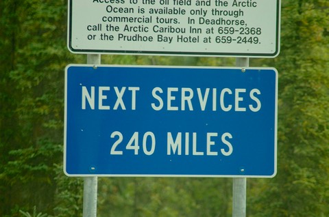
And the road up the North Slope to Deadhorse was a real experience. You have to take provisions as there are no grocery stores, so we packed in stuff for a week’s trip. You need to empty your sewer tanks, fill your water and propane tanks, and get fuel. This is almost a thousand mile trip, there and back. You can get fuel two places; you can find a dump station and water in one place. That’s it, folks.
The road is not there for the pleasure of casual travelers. It is there to take (haul) stuff back and forth that has to do with the pipeline. We are tolerated, politely if we keep out of their way, impolitely – even rudely – if we insist we have the right of way. Which we don’t, as clearly stated in all the literature given out. Frankly, we found the truck drivers delightful and happy to share the road with us, but we stayed firmly on the far right and stopped to let them pass. We had been told that if we had a CB, which we do not, to get on the truckers’ channel, as they were regularly checking back and forth with each other about critter sightings. The big trucks were a constant on the road; otherwise it was largely pickups and campers. The traffic was fairly heavy. The trucks were always loaded going north, but often they came down empty. It seemed to us that they had pretty set time limits on how long they could be on the road; one night we had truckers next to us, and they arrived, shut off their engines immediately (thank you!) and 8 hours later saddled up and took off again. Time is money, but we really appreciated their politeness.
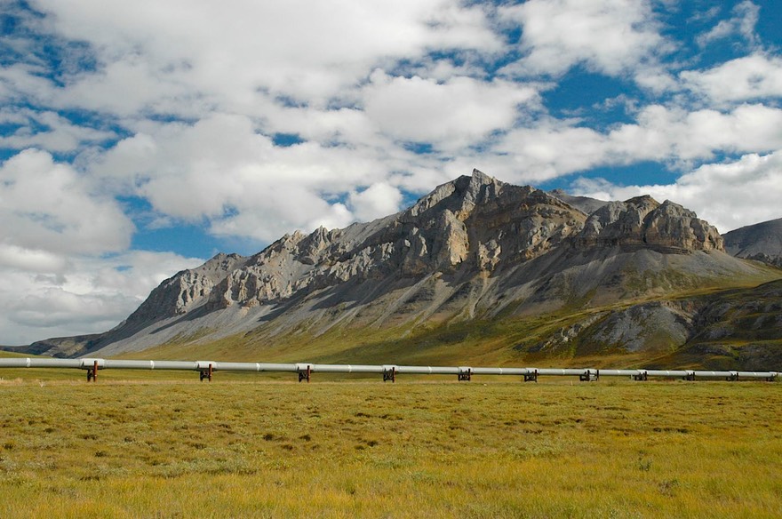
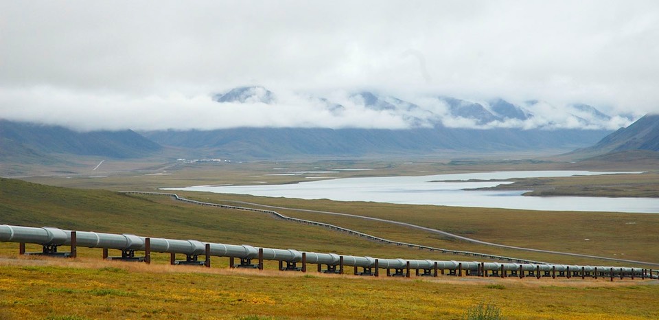
The road itself is bad to middling, in Kathy’s opinion. Rick is a bit more generous. Part of it is paved, even well paved. We ran into a lot of drippy weather, which turned long sections into yucko; seems this is pretty normal. Much of the road is quite rocky. However, and this is a big however, the road travels through some incredibly dramatic countryside. You start out through the northern edge of the boreal forest, and then into the same barren tundra we had seen on our trip to Inuvik. Further up, the road crosses the Arctic Circle and travels through the Brooks Range, crossing through over Atigun Pass, at 4739 feet the highest pass in Alaska and where we once again crossed the Continental Divide. This is the northernmost crossing of the divide in North America; waters from here north flow to the Arctic Ocean. Generally, the road parallels the pipeline; mostly it is above ground and running in plain view along the road; but it disappeared underground as it crossed Atigun Pass, and would do so from time to time again.
After you pass through the Brooks Range you begin crossing the North Slope, a vast barrenland with vistas for miles and miles. It was easier to see animals now, of course, and so more hunters were in evidence. They were camped along the road, but since only bow hunting was allowed within 5 miles of either side, they mostly were off in the hills. We saw one lady caribou of an evening, but no moose. Oh, and the fattest squirrels you could imagine! So chubby (preparing for winter, of course) they could hardly move off the road so we could pass. Burp, they said. And a cool-looking wolf, all on our way north.
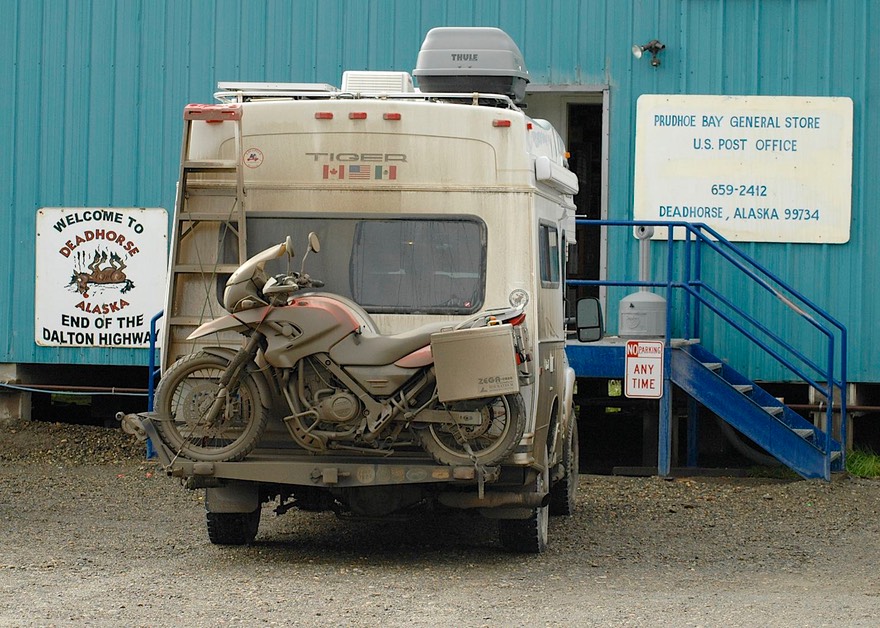
The North Slope finally gives way to the coastal plain which ends, naturally, at the Arctic Ocean. We were following the Sagavanirktok River; Prudhoe Bay is its delta. And then, finally, after traveling parts of 3 days, we were in Deadhorse, the end of it all. And of course there’s nada here; this is really nowhere, folks: The northern end of the northernmost road in North America. It was raining (“oh, it rarely rains here…..”) and was a sloshy, gooey mess. We had dropped down to 54 feet in elevation, but were at just over 70 degrees of north latitude… As far north as you can drive in North America – oh, did we say that already? I guess we’re kind of pleased with ourselves for doing something that most folks don’t (maybe they know something we don’t). This summer we’ve crossed the Arctic Circle on the only two roads on the continent that do so, and then continued on well above the Circle to the end of each of those roads.
So Rick took the tour, which gave him a chance to dip his toes in the Arctic Ocean and listen to a boring tour guide for a couple of hours; I’d opted to stay at home. Deadhorse is the town that houses the service people for the drilling and pumping operations at Prudhoe Bay and the two entities are basically one contiguous area, ‘though there is a fence and a security checkpoint at the only road that joins the two and no one is allowed to pass without the proper credentials. A fair amount of information was shared on the tour, particularly about how advances in technology over the past 30 years have increased the productivity of the oil fields while constantly decreasing the amount of impact the operations have on the surrounding tundra and wildlife. Overall, we left the area feeling pretty confident that a very good job was being done. We saw caribou grazing along the roads and were told that bears and musk oxen are also frequently seen. When the caribou migration comes in the spring and fall, they move right through the area where all this work is being done. One of the more interesting things explained was that all of the serious work of building and maintaining the drill sites is done during the winter when equipment with huge soft tires can cross the tundra without doing damage. There are actually a number of drill sites around the area, they’re not all right at Prudhoe Bay; and the sites that are not right there are only reachable by air during the summer, as no permanent roads have been built other than those right in Deadhorse and PB proper. All in all, an interesting tour, and yes, at 37 degrees, the water was a mite chilly.
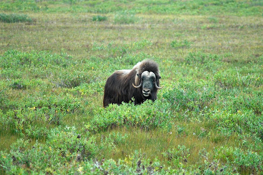
Having seen the sights (and finding nary a tee-shirt worth purchasing, sad to say) we started back down the hill. And our first night out made the whole trip worthwhile. We slept right across the river from a small herd of eleven musk oxen. It was soo cool. Imagine its 10:30 pm; too dark finally to take more pictures, but watching them actually playing around out there. And waking up in the morning, sticking your head out the window, and…..THEY WERE STILL THERE. A night to remember. In addition, on the way up, we had come across a single bull musk ox fairly close to the road and were able to get some really good pictures of him. These critters have a real attraction to us, especially to Rick. There is something so primitive about them, similar but even stronger than that of buffalo. When you look at one, it’s as though you are swept suddenly back in time to another world where such creatures exist. These sightings really did make the road seem well worthwhile.
We waved good-by to the musk oxen, and trudged on. The road was long but we made it, out of Deadhorse, down past Coldfoot and Five Mile, back across the Yukon River (forgot to mention that before – the Yukon again!); then, finally, off the Dalton and back on the regular highway (i.e., paved) and on into Fairbanks. Really filthy this time; $21.00 at the car wash got us presentable.
Coming down the Dalton, there’s plenty of time to make comparisons with our other major trek northwards on un-beaten tracks (i.e., “you’re going where?”) – the Dempster Highway up to Inuvik. When we came down off the Dempster, we had felt real regret; we had thoroughly enjoyed the sense of being away-away-away. Not this time; on the Dalton the trucks are constant, there is much more general traffic, no opportunities to take secondary roads and get off to yourself; and at least one of us thinks it’s a pretty crappy road. We were both glad to get to civilization. Riding the Dalton, we had traveled 845 miles of unpaved roads; we spent 25 hours and 52 minutes in driving time at an average speed of 33.1 mph. A slow slog. We’ve said it many times: we will come back to the Dempster some day; not to the Dalton – once was enough. But now we have bragging rights! Been There, Done That!
Back in Fairbanks, after we got cleaned up we went to the movies, had pizza, rejoiced in a working cell phone, etc. Fairbanks has a good bookstore and a great library, both of which we enjoyed. The city is known for its summer flowers and fresh vegetables, which were a real delight. The farmer’s market is huge (and so are the prices…..) and we indulged our eyes as well as our pocketbooks.
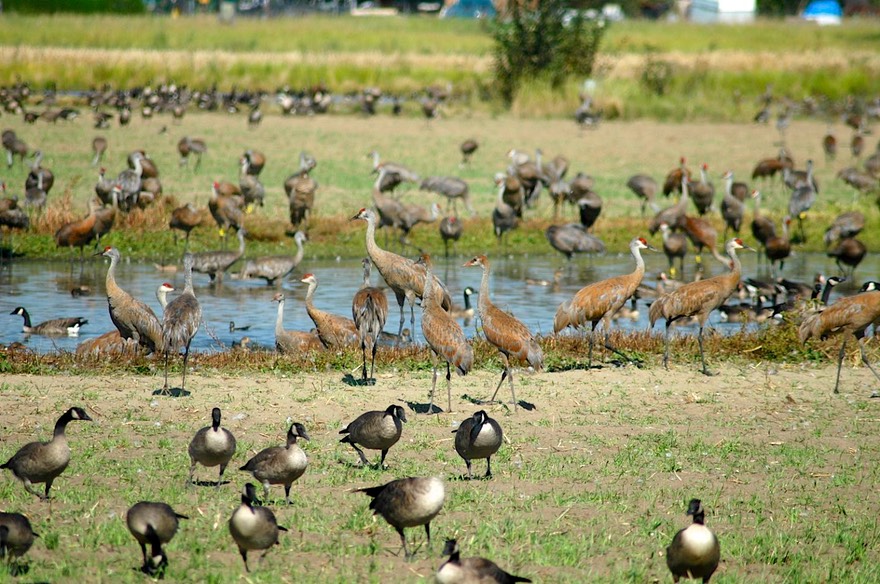
Amazingly, for once our timing was spot-on: the sandhill cranes were in town. Seems they pass through Fairbanks on their way south for the winter; they were in gay profusion, particularly in the fields surrounding a dairy farm on the edge of town. There were plenty to go around for the constant visitors who come to see them, a festival was happening soon (crane ice cream, anyone ?) and we got some great pictures. These were the same cranes we had tried to take pictures of in the area near Yellowknife, NWT, this time with more success.
Then on to Denali NP. Having visited the park on our last trip, and having had such good weather then, and it being cloudy and uninteresting now, we didn’t plan to stay long. But we checked out the exhibits at the visitor’s centre (some of the best in Alaska), and after adding to our tee-shirt collection, we trucked on down the road.
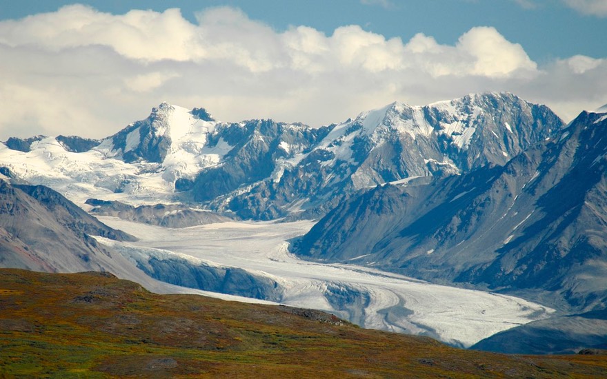
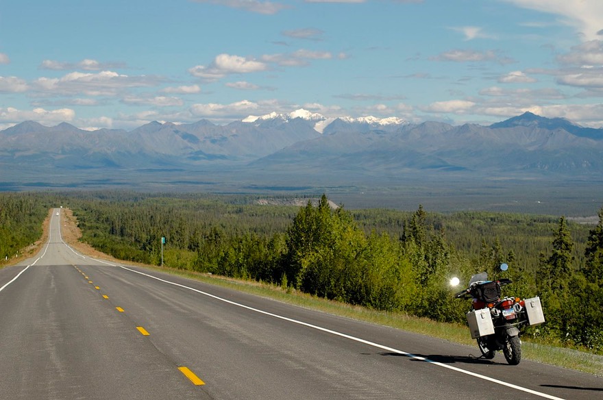
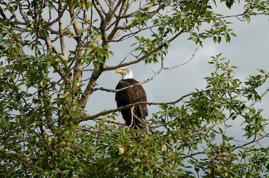
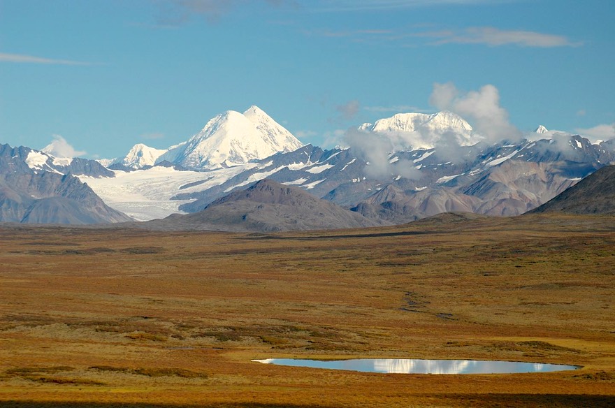
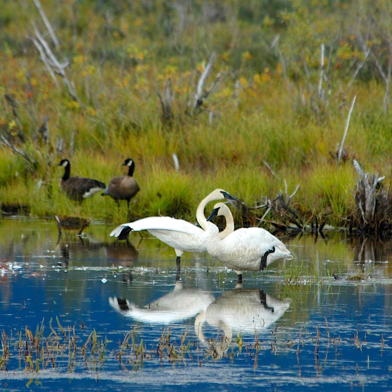
And the road we had chosen was magnificent, absolutely!!! This was the Denali Highway, which heads east from the park, an unpaved road that parallels and passes through the Alaska Range (Denali is part of this range) for about 130 miles. We took three days. We had wonderful weather, incredible views, a quiet road (except for the hunters) and it was super! This was a part of Alaska we’d not seen, and it’s some of the best scenery the state has to offer. There were many lakes with plenty of waterfowl, including the trumpeter swans coming through this time of year. The trumpeters are big, white, and travel in pairs; apparently they mate for life, although there are reported infidelities. We did see an occasional threesome, although we promised not to report them to the Audubon Society. We got great pictures of an eagle sitting in a tree who couldn’t be bothered to flee from us, merely kept one eye fixed balefully on us as we crept ever closer. One night we camped by a river and gathered enough blueberries to keep us in pancakes for months. There were plenty of other berries as well, but none nearly as tasty. (Some people come to Alaska to hunt and fish; we come for the berries.) We crossed the Susuitna and McLaren Rivers, then over McLaren Pass, the second highest in Alaska after Atigun Pass on the haul road. We saw sled dogs practicing for the coming winter by eagerly pulling an ATV down the highway.
Emerging back onto paved road, we ducked back up to Tok (redux numero duo) for business, then trucked on down to the Wrangell-St. Elias wilderness and preserve, much of which is a national park. Along the way we had one of our few good bear sightings. There are only two roads into the park, both unpaved. We decided to head in toward Nabesna, which we had been told was a lovely area. No false advertising here. We were delighted. We traveled the entire 40-odd miles, then came back to a pretty place we had spotted beside a stream, and stayed there for several days, getting the bike down to ride much of the road a second time. There was one water crossing and several other dry but gravel-strewn creek beds, so Rick got lots of opportunities to work on his off-road skills. It was warm during the day but cold after dark (down to 26 degrees one clear night). The fall color had taken hold in the mountains at hand; mostly yellows with occasional oranges and reds.
We could have stayed along the Nabesna Road for many more days, but we had plans (and reservations even) to take the ferry from Valdez to Cordova. So on we had to go. We reluctantly left our little bit of perfection, emerged back onto the highway, turned south along the mountains, and headed for Valdez. And it was deja-vu all over again – hey: there’s the Alaska pipeline! Well, duh! The pipeline runs from Prudhoe Bay to Valdez, doesn’t it! And it follows road beds where possible, so as not to have to reinvent the wheel. So south we all went to Prince William Sound and the pipeline terminal.
The road to Valdez travels through some of the prettiest scenery in Alaska, and fall color was becoming more and more evident; it was lovely. There are mountains to admire, waterfalls to see, a deep canyon with rushing water to meander along, and Valdez at the end of it all. Valdez with expensive, uninteresting food, mediocre weather, and nothing much of interest we hadn’t already seen in town. But we were cool. We found wi-fi (it cost us an $8.00 piece of chocolate cake because it was in a restaurant and we -- Kathy actually -- feel guilty about using without paying) and got caught up. Being Labor Day weekend, the port was on heightened alert (all those huge oil tanks were full, undoubtedly), but it didn’t affect us.
And then, the purpose of our heading in this direction, we took passage on the ferry to the fishing village of Cordova. It was fun; we were traveling on a VERY nice ferry, just two years old and all spiffy and clean – and traveling at 36 knots thank you, and the weather cooperated during our ride out into the lovely Prince William Sound. Landing in Cordova, we wandered around for the next several days having a hugely good time. Cordova is big enough and clean enough to be entertaining and fun. A funky museum showed the town off proper; the library had excellent wi-fi, so we stayed current; and there’s a lovely 50-mile road you can take that leads out to Childs Glacier, which is RIGHT THERE. We took tons of pictures of said glacier (they really are very blue), camped nearby for the night (brrrrr), and trucked on back into town the next day. The glacier was calving regularly because it was the end of the warm season, and we got to hear it roaring a lot. Cool.

The road traverses the Copper River Delta, one of the largest around, and it’s pretty darn neat. The river is fed by six different glaciers (very chilly), and is heavily braided, if you know about such things. Also very high (see warm weather glacier comment, above). So we crossed a zillion bridges. It was all marshy, and full of waterfowl. This is where the trumpeter swans hang out before heading south, and it’s also the only spot in the world where the dusky Canada goose nests. (Now you have all the pertinent wildlife information.) Oh, yes, and then there’s the salmon. Salmon’s the reason that Cordova exists. A huge fishing area, the salmon in one form or another have been running all summer and the place is full of sportfishermen; of course the town all fishes, too, for a living. We sure have felt out of it here in Alaska when it comes to fishing and hunting! But we press on, regardless…..
We had both good and bad weather in Cordova; during the good we took pictures; the rest of the time we caught up on projects and chores (and email). In the harbor we saw sea lions and sea otters, along with lots of salmon jumping out of the water, trying to get upstream (but they were in the harbor so they didn’t get anywhere….). There were eagles in the trees along the delta, and we got constant reports of bears in the area; everybody but us was fishing for salmon. So: Cordova is a great spot; we recommend it to anyone who wants a taste of southeast Alaska. We met several people who were living there on purpose, quite happily we understood. About weather? They are sort of on the dividing line between snow and rain; they get between 6 feet and 22 feet of snow each winter; what’s not snow is rain!
While there, we watched a film crew working on a new movie about the Exxon Valdez spill; we’ll be looking for it. Local gossip, by the way, is that some money may actually be forthcoming in the near future -- the spill was in 1989. No comment.
We left Cordova on a ferry that took us to Whittier, a closer port to Anchorage, our next target. Crossing the Sound was quite choppy this time, but we hung on. Leaving Whittier, you go through this weird train tunnel to get off the peninsula, only room for vehicles going one way at a time so it’s well controlled, especially with trains taking turns along with the vehicles; makes me freaky, but I managed. Then on around Turnagain Arm, up the hill, and we had joined civilization, Alaska-style. We found a welder (with turquoise hair – really!) to make a quick repair to the motorcycle rack (we’ve been visiting welders all over North America), a library, the great Anchorage art/history museum, an art film house, got a service done on the truck, all the usual things in our city-fix mode. And we had a delightful visit with son Jason and some very nice friends of his. We even went out to see the herd of musk oxen nearby; they are penned and are farmed for their wool, which is incredibly soft – and incredibly expensive. Anchorage makes for a nice place to hang out for a bit, but it’s too big for us, and it was really rainy. So off we went again.
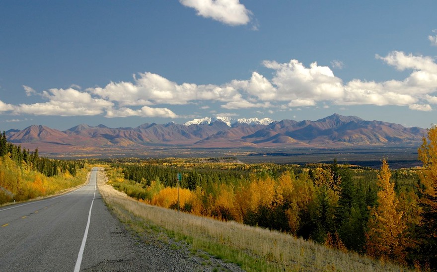
By now we were making a run for the border, the Canadian border, that is. And of course that took us back through Tok. We got lucky along the way: we had a lovely turn of weather, Indian summer to the locals, and as we were traveling through some very pretty scenery, we took our time. By now, the fall color is really in full swing, and it is incredible. This day gave us the opportunity to get some really great fall color shots.
Arriving in Tok (redux numero tres), we of course had a list of things to do. The list was nicknamed Alice, of course. Why of course, you ask? (Thought you never would….) well, it’s a Tok List; so….it’s an Alice B. Toklas. What? You think that’s awful? Course it’s awful; that’s what makes it fun.
Our Tok list didn’t hold us long and we headed for Canada…..and more expensive fuel. But it was time. The weather was increasingly rainy and cold, and we had a long way to go before arriving back in Rapid City, South Dakota. Our plan is to take our time, and enjoy British Columbia in the fall as we work our way back to the good ole’ US of A. We have really enjoyed our summer in the Northwest Territories, the Yukon and Alaska, and have a list of places still to visit when we are in the area again (always have to leave something for the next time).
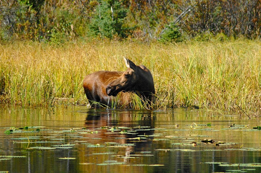
Looking back, the Far North, as this area is known, is an incredible land. “North of 60” the locals say; they are talking about the entire area above the 60th parallel, which is the dividing line between Canada’s provinces, where 90% of the population resides, and their northern territories; and for our purposes we include Alaska. Clean air. Wide open spaces. Wild animals everywhere (we’ve seen: Moose, Bear, Musk Oxen, Buffalo, Caribou, Wolf, Fox, Beaver, Marmot, Coyote, Lynx, Eagles, Trumpeter Swans, Loons and more Geese, Ducks, Squirrels and Chipmunks than you can shake a stick at). Large rivers too numerous to mention, not to mention streams and creeks by the hundreds, and all of them rushing along, full to the brim -- water, water everywhere, at least this year. Mountainous mountains. Cold blue glaciers. Long, isolated roads with little towns at the end. Berries to be picked. Relatively little intrusion by man. We really feel good when we’re up here.
We’ve had great adventures. We’ve gone as far north as you can drive in North America, including reaching the Arctic Circle twice – in both countries (only 6 more to go! Can you name them all?). And we accomplished this by traveling on the famous Dempster Highway and the infamous Dalton Highway, The Haul Road; these are places most folks just don’t go. We’ve made acquaintance with two mighty rivers, the Yukon and the MacKenzie, each of which was the only way early travelers could use to move from developed lands into the wilderness. We have traversed the Continental Divide 13 times, with at least one more crossing ahead of us before we return to South Dakota. We’ve weathered the Midnight Sun, and stayed far north long enough to see the seasons change and enjoy beautiful fall color; actually that’s an understatement, the color has been extraordinary. As we finish up this message, looking out the window we see new snow on the peaks around us as winter approaches. We’ve traveled about 3700 miles on unpaved roads, without a whimper (well, there were a fair number of oofs along the way, and a lot of muttering at various coin-operated car washes here and there). The variety of scenery and wildlife up here is stunning and seemingly never ending; but, the key for us has been our greatly increased ability to get off the beaten path and back in the woods where fewer travelers go. We’ve learned that when it comes to RVing in the North, less is definitely more.
So. We are on our way south, through beautiful British Columbia, and at some point in October, crossing back into the States down Montana-way. We hope to be able to cross the Rockies in Glacier National Park, over the Going-to-the-Sun Road, which was still closed when we were there in June. Hopefully it isn’t already closed again! When we get to Rapid City we have lists of things to accomplish before we head out on our Latin American sojourn. Will we get out of Rapid before the snows fly? Stay tuned!
Kathy & Rick