October 2004
A New Founde Lande
Newfoundland and Labrador
A land of bent trees and water that looks like beer.
Or… I’m not leaving Canada without a tee-shirt from Labrador – no way no how
Have you been to Dildo, Virgin Arm, Come By Chance, Little Heart’s Ease, Goobies, or St. Jones Within ….? They’re all in Newfoundland. We didn’t dare ask how Dildo got it’s name, or Goobies, either!
One of our big goals for this summer was to spend some time on Cape Breton Island, Nova Scotia, and then go to Newfoundland. You know, of course, that it’s not really Newfoundland, it’s Newfoundland and Labrador. No, I didn’t know it, either; but the two areas were joined at the hip at the time of Confederation with Canada in 1948. And Labrador’s cool; more on that later. (Pronunciation guide: new-fund-LAND, and lab-ra-DOR).
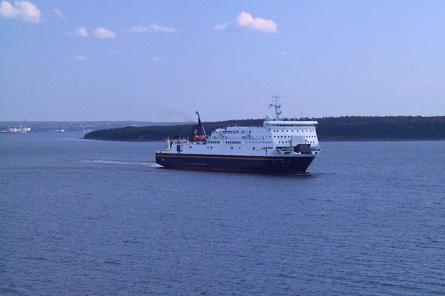
After three weeks on Cape Breton Island (we’ll cover Nova Scotia in our next message), we were ready to tackle Newfoundland. There are only two ways to get there (short of flying), and both are ferries that leave from Sydney harbor at the top of Cape Breton Island. One takes about 6 hours or so and arrives at the western end of Newfoundland; the other takes 16 hours and comes into the eastern end (there’s only one road that connects from one end of the island to the other). We decided on the shorter hop, so we made our reservations for a Wednesday, and on Tuesday were glad we’d decided to wait one more day, as that was the night the edge of Hurricane Charlie came through and the water was REALLY ROUGH. Wednesday, however, dawned beautiful and calm, and we had a peaceful passage with a nice sunset to boot. We arrived in Newfoundland, very excited, in the late evening. We found a place to hole up for the night and started a brand new adventure the next day.

First impressions? Newfoundland is awesome; other-worldly, very northern but somehow tropical looking. A distinctly different and constantly varying place. We’ve seen all sorts of different terrain as we’ve traveled the island and will be attempting to describe it all to you as we go. In planning our route for this summer the first thing we did was to decide to come to Newfoundland fairly late in their season. We did that based on input from other travelers and locals we had met on the road regarding weather, bugs, and the amount of other travelers. We came over on August 17th, by which time most others from “away” had already gone back, and for the most part we’ve been pleased with our choice. By coming late we have missed most of the famous black flies, and that’s a big plus. These little suckers bite, get in everywhere because they’re so small, and are generally a real pain. We had some in the first week or so we were on the island, but almost none since. We also have missed the bulk of the other tourists. In fact, the ferry schedules cut back the very week we came over as most folks are on the way home by then. As a result we’ve had an easy time getting sites in the national and provincial parks we prefer to stay in, and little other RV traffic on the sometimes narrow roads. On the third factor, the weather, we kind of missed out this particular year as the best weather came in late July, early August. When next we come out here, we’ve decided we’ll brave the flies and come earlier in hopes of seeing more wildlife and especially icebergs. Probably won’t help with the weather though; it’s notoriously problematic all summer long; and as for the winter - fugetaboutit.
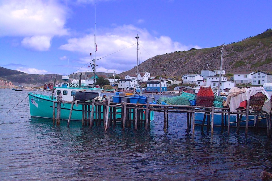
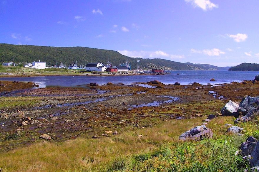
We started in the southwest corner of the province, with the obvious intention of moving north and east all the way across to St. John’s. The southwest seems to be a bit of a banana belt, with much of the province’s agriculture in that immediate area. We saw potatoes, dairies and even corn in the fields (boy, that corn is never going to reach the height of an elephant’s eye). This is a low country, with short, windswept trees, barren areas and nasty winds. We wandered along the coastline, among very poor Basque communities from the ancient fishing trade in that area. Interspersed among the small, old homes were larger, newer more prosperous houses, complete with satellite dishes. Oh, and we saw alpacas, being raised on the side of the hill overlooking the water, out in the middle of nowhere. We settled into a provincial park, only to be rained on for the next three days, before moving further north to Gros Morne National Park, one of the most incredible highlights of a visit to this incredible province.
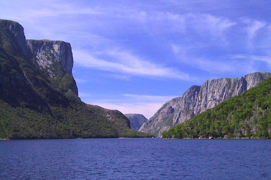
Gros Morne NP is truly wonderous. It is a UNESCO World Heritage Site. These were established to protect areas all over the world that are of vital significance from a historical, scientific, or cultural standpoint, such that their destruction would be a loss to the entire world community (I only sort of copied that.) There is incredible geology here and it is a beautiful park. It is slightly exotic, sort of Jurassic Park-looking, but with very stunted (and bent) trees and shrubs that make up what is called the tuckamore. The wildflowers are incredible, even in August. We took a boat ride up a naturally dammed fjord that was breathtaking. We camped on the shores of bays and overlooking the sea. We tromped bogs, picking out the pitcher plants and the ripening berries. We checked out the Rocky Harbour Groceteria, and passed through Cow Head, winner of the 2003 provincial Tidy Towns award. We passed arms, brooks, ponds (really huge lakes) and tickles. (A tickle is a very narrow arm of a bay.)
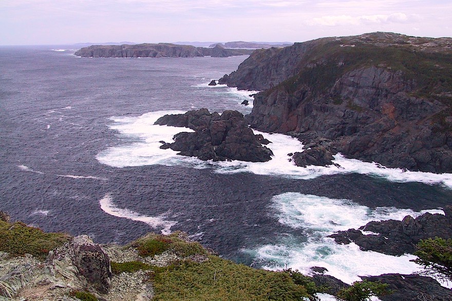
This is the incredible northwest coast of Newfoundland, the rugged coastline leading up to the narrow channel of the St. Lawrence where it passes through the Strait of Belle Isle, a nasty area that forms the shortest route for ships heading for Quebec and Montreal; in winter the ships must take the longer route passing south of Newfoundland. This is where the ferry travels across the water and takes you to Labrador. But more on that later. We visited historic sites discussing early tribes that inhabited the area, passed a funky-looking Museum of Whales and Things (really), and kept on trucking. We were now passing signs along the road with pictures of moose facing cars -- cars with smashed up front ends. These moose mean business! We were paralleling the Long Range Mountains, believe-it-or-not the northern tip of the Appalachian Mountains (the southern tip is in northern Alabama and Georgia).
We went all the way up to the top of the peninsula, passing out of the park and passing one pretty little cove after another. This is an incredible coastline, filled with tiny fishing villages; each village has a few small, square, plain houses and piles and piles of crab pots and lobster nets. At the end of the road, out in the barrens, is a real mind-blower: L’Anse Aux Meadows, the site of the Viking landing in about the year 1000. this is another UNESCO site, and well worthy of the designation. The interpretation centre here is excellent, giving tons of information about what they have been able to prove. The site was discovered in the 60’s, by a couple who had done tremendous research and figured out this was a promising location. The dig was very exciting and went on for several years. Our guide on the walking tour was born and grew up nearby, remembers the arrival of the researchers, helped with some of the excavation, and now works for Parks Canada. He had cool information to share. To tell you how remote this spot is, the road to this part of the peninsula was put in because of this site; before that all travel between villages was by boat, as it still is in other parts of the island.
Newfoundland is unique in that there are no bears, snakes or skunks on the island. They have their own Northern Lights (although we were never in the right place at the right time). There is little enough traffic that folks walk along the roads, both for exercise and to get where they’re going. And people just stop in the road to chat. It’s a nice place.
Oh, but did we tell you about the roads? Somehow they have not yet mastered the mating of the asphalt roadway to the concrete bridges. Every bridge crossing is a disaster; the roads are even a bit worse than on Cape Breton Island; and there aren’t enough of them. Glad we weren’t in a hurry; we just slowed waaaaay down, adapted our pace to the conditions. Once we learned how to do that, it really wasn’t too bad. Oh yeah, and you can tell by the skid marks when you are coming up on a place in the road that is badly “altered?” by frost-heaving……we’ve learned to take such indicators seriously. And these are major highways we’re talking about; side roads, where they exist at all, can be true disasters. But, the roads are not nearly as bad as in Mexico, so everything is relative.
And yes, we took the boat to Labrador for a day. What an exciting day! We had to be at the terminal at 5:00 am to arrange for passage; the ferry left at 6:00. After 1-1/2 hours aboard, we landed, not in Labrador (too easy!), but at the very edge of Quebec where it touched Labrador. Who knows why we landed in Quebec; maybe because this border area wasn’t defined until 1947 or so. It was 8:00 in the morning, overcast and colder than hell, we were on the bike, and didn’t have the foggiest idea where to find a cup of coffee.
The visitor’s centre was still closed (what do they think all us early birds are going to do for info???) so we began riding, and riding, and riding. Cold, cold, cold. Fifty miles away is the end of the road, at least the paved part. That’s all there is! Beyond that is 800 miles of dirt/gravel road, combined with ferry rides, and this is how you can get to Goose Bay, Labrador City and on to Quebec. What a kick! But by now it was getting warmer, the sun was coming out, we found a cuppa and a bun, and we were having a fine time. We prowled Red Bay, the biggest “town” on the coast; that took a few minutes; but what a beautiful, lonely setting. We visited a historic site that talked about the Basque fishing here, starting in the 16th century, followed by the French and English. The cod fishery was enormous. It started out with all these folks showing up for the season and then going back to their warm beds in other countries when the weather started getting bad. But when it stopped being a summer thing, and permanent settlers arrived, the territory was something to fight about ….. for hundreds of years. Ultimately, England, in control, sort of gave Labrador to Newfoundland, in exchange for other lands the French wanted more. There are interesting stories about the times of Confederation, when PEI and then New/Lab joined Canada as separate provinces. Big fights. This was in 1948, not long after the war, and Newfoundland/Labrador was even considering maybe becoming part of the United States, having to choose which way to go. It had finally become abundantly apparent that they needed to join forces with some larger entity; they were starving out there on their own. In the end, the majority voted to join Canada, probably the better decision.
Labrador is beautiful, at least in August. It is surprisingly green, with an exotic color that’s even different from the area we were just visiting in Newfoundland. There are lovely bays, each with a small fishing village; very little else. No trees. We stopped for lunch in a small restaurant attached to a hotel, and emerged to find a fellow motorcyclist looking at our bike. David from Dallas was quite a guy. He has thirteen motorcycles and a day job designing and installing the custom interiors of private jets; not talking Lears here, but 747s; for people like the king of Saudi Arabia. Amazing stories. In his spare time he vacations on his bikes, often alone, and he had just completed the 800 miles of dirt/gravel road that make up the other way to get to Labrador, from Quebec. Last year he rode up to the Arctic Circle. A terrific fellow, we were pleased to meet him. He was cute, too.
Our afternoon included a visit to a beautiful restored lighthouse at L’anse Amour, and we ended the day back at the Quebec-Labrador border, took the ferry (delayed an hour or so because a ramp was malfunctioning) back across the bay in time for a lovely sunset across the water, and fell into bed 17 hours after our alarm had gone off that morning. It was neat, and we’ll go back. We’re looking hard at the dirt/gravel road. It leaves from Baie Comeau, Quebec and goes due north to Labrador City, then east to the coast, through Happy Valley-Goose Bay. The word is that the dirt/gravel part is in great shape; it’s the paved section partway north out of Baie Comeau that’s totally rotten (thanks, Quebec). We’ve been told it’s a GREAT trip; maybe in a couple of years.
We poked around the northwestern tip of the province for a couple of days, staying in a park that promised us moose. We even saw one, very close to our coach early one evening. Unfortunately, someone pulled up in their car, got out slamming doors and opening trunks and taking out camera equipment, all very loud, and the poor fellow left. That’s our last moose sighting to date. Otherwise we’ve been moose-less in Newfoundland. And the caribou everyone talks about???? Carib-who??? Oh, well, guess we can’t complain too much. We haven’t been hit by anything either!
I felt we were leaving a rarified atmosphere as we departed from the northwestern peninsula; this seemed like very special land. But ultimately we needed to move on. We passed back down through Dark Tickle, where we bought squashberry spread (Tartinade de pimbina) for our toast; back through Gros Morne NP, where we spent one last night on our favorite bluff overlooking the crashing waves; and rejoined the main road to begin to make our way across the large interior part of the island, heading for St. John’s, all the way on the eastern edge. The road, the only road that transects the island, for the most part follows the railroad bed that once crossed the island, the railroad that was built before there were any roads. For you see, most of the interior of this province was, until recently, pretty much uncharted territory.
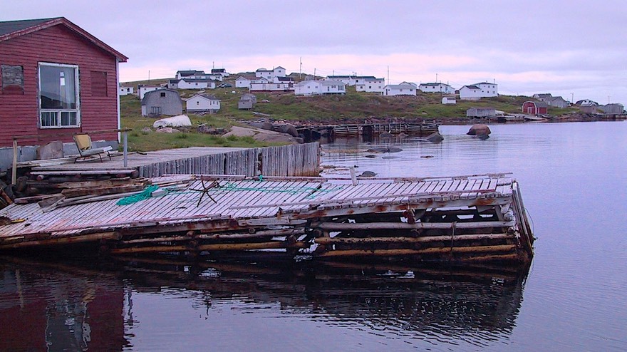
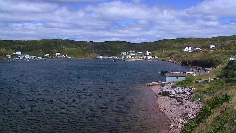
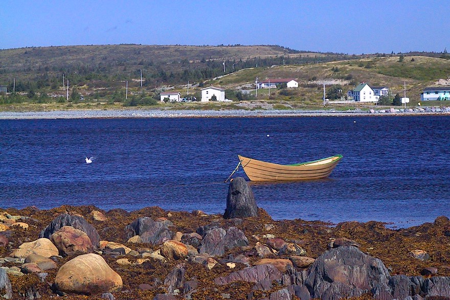
But we didn’t go straight to St. John’s, of course. We found ourselves in the middle of the Labor Day holiday; and the locals are out there, just like in the states, taking up the best camping spots and cluttering up the horizon; well, they are the locals after all, they got “rats” (have you read the civil war novel, “Killer Angels” or seen the movie based on it, “Gettysburg”?). To keep clear of the Labor Day weekend crowds, we decided to head down into the southern part of the province, down a long, lonely road to an area called the Coast of Bays. This included the Bay d’Espoir, which means Bay of Hope but is pronounced by the locals as Bay Despair. Seems no tourists go down there; it was very quiet. We were really out in the middle of nowhere. And the southern coast was gorgeous. Bay after tiny bay with tiny communities connected mostly by boat. The school buses were sitting beside the road, all shined up, waiting for Wednesday and the first day of school. Kids were out walking the roads or playing street hockey. They thought our bike totally cool; so did their parents, also out walking. These folks walk, lots; we saw trails all over the province, well maintained, and obviously well used.
There are these remote areas on all the edges of the island, connected by boat and these small feeder roads. It appeared a cottage industry has developed, a shuttle service if you will. We saw a station wagon, for instance, loaded down with a U-Haul. We saw it several times during the day, visiting the small hamlets, dropping stuff off for folks. We suspected it probably made a weekly run into the closest larger town (or maybe even into St. John’s), picking up stuff, taking people to the airport, getting things, etc. That’s how it works when you’re really out there.
In this area, they don’t see many tourists, as it is quite remote, at the end of a dead end road, but it was really worth our visit. We saw tarns, fjords, tundra; this is a remote, barren area. But fascinating. It reminded us of the Beartooth Highway, the road from Red Lodge, Montana into Yellowstone National Park, if you’ve driven that route. The M’ikmaqs (First Nation tribe) are a real presence in this area, and we stayed in a nature park run by them, Jipujijkuei Kuespem Park (Little River). Rick knows how to say that. But better ask him soon…… Oh, yeah, and this is an area where we were promised caribou; yeah, right. Nary a one in sight. But the bogs were full of ripening raspberries, blueberries, partridgeberries, bakeapple berries, you name it. We were seeing car after car parked on the side (actually mostly ON) the road, with folks out in the bogs along the roadway picking berries for later.
Not just along this coast, but everywhere in Newfoundland, all the trucks are pickups, and they all have ATVs in the back; we presume for hunting and for bringing home wood. In the forested areas, individuals have wood lots, which they use extensively. This is very, very cold country, remember. You’ll pass by huge stacks of wood, all cut and sized for burning, sometimes with sleds piled beside them. On the weekends, families are out loading up wood, cutting it to dry, cord after cord after cord. We spotted large tepee-like structures made from longer, thin trunks, all poking up into the sky. They dry that way, then are taken home to both burn and use around the property (fencing, corrals, etc.).
Another oddity was the frequency of large individual gardens along the road, out in the middle of nowhere. We found out that much of the topsoil near the coastline is too poor for gardening. When the roads were put in, the construction created areas of “good dirt.” These spots have been claimed (probably by simply continuously working the area) and are used by individuals. We asked if anyone ever stole stuff, either from the gardens or from the cut wood piles, and were told that it just didn’t happen. These areas are so remote, and everyone knows everybody’s business so well, that “someone would know.” So it doesn’t happen.
After our Labor Day weekend away from the “crowds,” we decided to make one of our famous course changes. The weather was looking damp for the next couple of days so we determined to bypass a part of the northern coast and head off to St. John’s to get a “city fix.” We hadn’t seen much civilization since Quebec City back in early July, and we wanted a movie, and pizza, and bright lights, and tee-shirt shops. So off we went. We stopped in Gander along the way. Gander, you may remember, was an important place during World War II; and afterwards, before aero-technology figured out how to get all the way from the U.S. over the Polar Route to Europe non-stop (i.e., without stopping to refuel in Newfoundland). Now it’s not much of a nothing, and they have a puny little aviation museum that tries to tell about the glory days, but not very well. Disappointed and glad it had been a free admission day for some reason, we moved on.
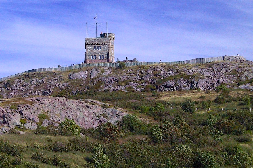
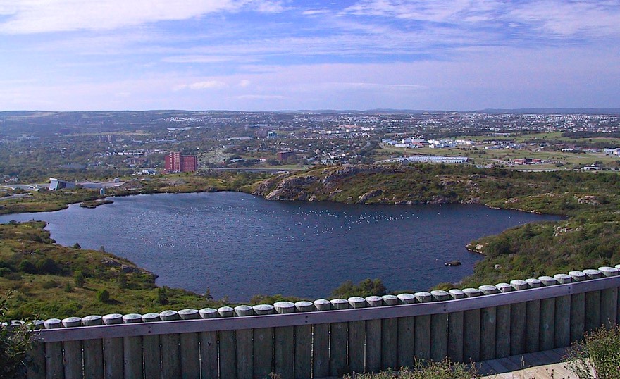
St. John’s is all it’s cracked up to be: 100,000 people, nice university, real streets and buildings, lots of pubs, used book stores even (we were able to pick up a used copy of The Shipping News, which we’re re-reading), maritime shipping, town on a hill, etc., etc. This is the biggest spot anywhere; St. John’s is definitely the tail that wags the dog, influence-wise. We stayed in the local city park, very happily. It was close to the university, which was a delight. Great to see kids again. Good library with great facilities, too. We saw 3 movies: one better than it should have been, one about what we had expected (quite good), and one much crummier than it should have been. About par….. Good pizza, a swell tee-shirt for each of us, and a good visit to the local sites. This included a trip up to Signal Hill, which is a lookout at the top of a hill at the entrance to the harbor. Constructed hundreds of years ago, manned by each country in its turn, it has great significance in local history. Until recent times, every day at noon a cannon boomed. Strategic, and with an incredible view.
St. John’s is also home to the Johnson GEO Center, a fascinating oddity. This is a museum with a great overview of geology of the world, but particularly of Newfoundland and Labrador. Newfoundland is actually made up of 3 entirely different chunks of land (oooh, my college geology professor would really love “chunks”): the far western area is mountainous (remember, northern tip of the Appalachians) and once was part of North America. The middle, largely undeveloped (and largest) part of the island is very old rock that once was at the bottom of the sea; it’s mostly barrens, mostly uninhabited. The easternmost part is the Avalon Peninsula (actually several large bump-outs that make the area look kind of like a starfish); it was once part of Africa; it has a somewhat milder climate; and it contains the most people. These three sections of land collided at some point in geological time, and formed this island. Newfoundland, and particularly Gros Morne, is a geological hotbed; the most accessible place on the planet where absolute proof is found of the movement of plates or continents about the globe.
A word about Labrador here; it got kind of short shrift earlier on. Labrador is a large chunk of land carved out of the Quebec mainland. It was important in history only because of the cod fishery, which was incredibly profitable. And there were seals to clunk on the head. Otherwise nobody cared about the area; there were native tribes that were permanent residents, but they got killed off when they got in the way. After the cod and the seals ran out it disappeared off the map. But then someone discovered a spot where a huge hydro power site could be built. So that’s why we care about Labrador and people fight over it. The little bit we saw of it looks like western Newfoundland, only more so. The rest will have to wait for a future adventure. As we said, it was beautiful in August; wouldn’t want to winter there.
While we were in St. John’s, we had one HUGE TREAT: the largest cruise ship of its kind ever to dock at St. John’s came in about noon one bright sunny day. We stood with all the locals and gawked as it made its way in through the very narrow harbor entrance, and then slid right up to the dock. It was quite a sight. Don’t remember the name of the ship, but it was a Carnival Princess of some sort; new, and really, really big; around 100,000 tons and twenty stories tall (or something like that). Anyway, there was no way this thing could have come into the small harbor at St. John’s without some impressive modern technology. It slid in through the Narrows, paused in the middle of the harbor, and simply spun itself around on its axis like a lazy susan; then backed into the dock. Amazing sight.
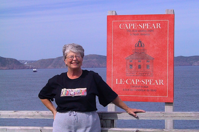
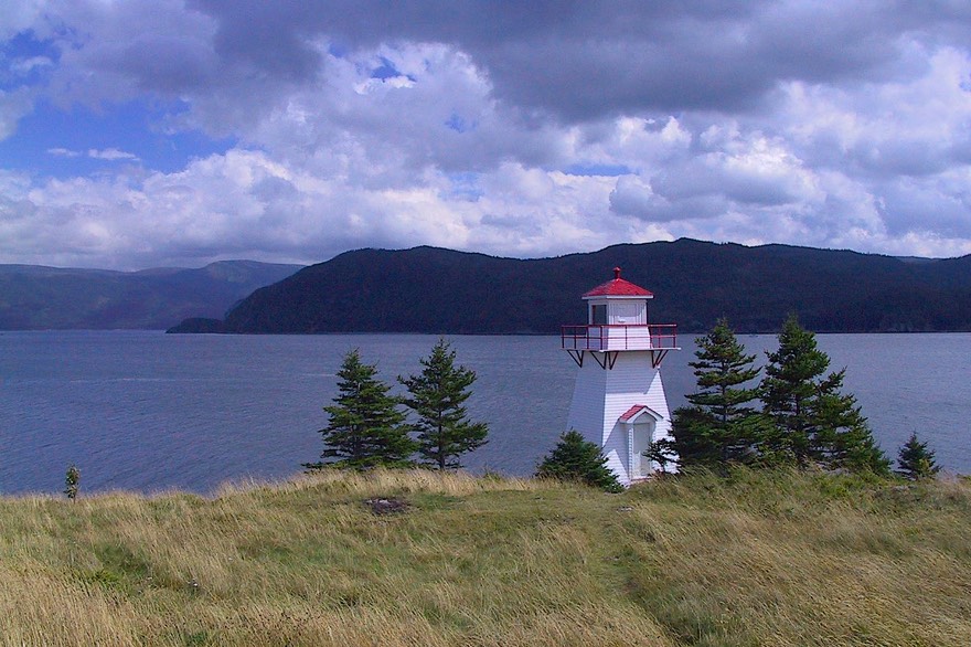
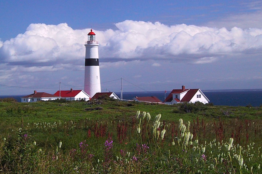
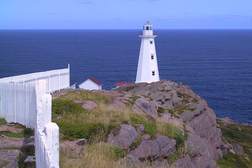
We could have stayed longer in St. John’s, but the day always comes. As we left the area, we visited Cape Spear, a marvelous spot. This is the easternmost point in North America; how about that! There is a nicely preserved lighthouse, picnic grounds, hiking trails, and an incredible view. One of the most photographed places anywhere. It’s an historic site run by the government, and the Parks Canada guide was incredible. She talked a lot about the life of a lighthouse keeper, the opposing forces of prestige vs. isolation. They were paid in cash, in an almost cashless society, hence prestige. But boy, did they live in out of the way places. We have visited other lighthouses in Newfoundland and have noticed that often they are maintained by members of the same family for several generations. It seems to take a certain type of individual, and like breeds to like? It was fascinating.
We started south from St. John’s, down the Irish Coast. There are very old towns here, so old they were “visited by the Mayflower” – Renews; Ferryland (you must go see Rhonda at the Ferryland Café, she with the house guitar for visitors and the best muffins anywhere). This area seems to have a “softer” climate. There are nicer homes, more sophisticated towns. We’re now beginning to see a little fall color. The dogberry bushes have huge clumps of red berries on them; they look like large rose bushes from a distance. Folks say it portends a hard winter when the berries are this big. They were lovely to us, who were leaving before the snows started to fly.
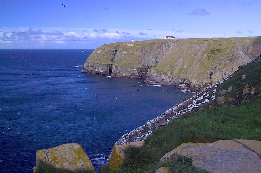
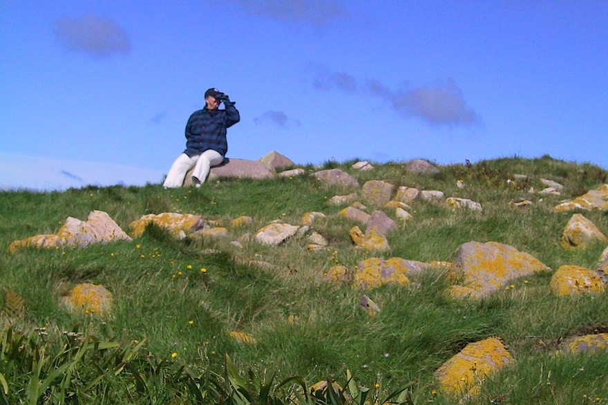
We made a special stop at the Cape Mary Ecological Reserve. This remote spot, at the end of a long peninsula and near nothing, is possibly the best place to see nesting birds without having to go off in a boat. Different birds pass through going north or south. We spent a good two hours being awed by the gannets currently in residence. The cliffs at Cape Mary are very steep, and the birds nest in nooks and crannies. They were absolutely EVERYWHERE. Rick took zillions of pictures, we fought the wind getting to and from the viewing spots, and it was incredible. For a couple of non-birders, it was quite an experience. And we never did get pooped on!
Cape Mary is at the southern tip of one of the peninsulas (remember the starfish) and we wanted to see some of the area further north, an area often spoken of as being some of the prettiest on the island. So we headed for the Bonavista Peninsula, which is where John Cabot landed in 1497. (There’s a statue of him up at the tip of the peninsula, along with another cool lighthouse.) This is fishery country, where cod ruled the land for so long. Here has been preserved an historic merchant’s property, one of the largest, as part of a very nice display. Rick endured the smell of cod without a murmur, as I dragged him through yet another fish museum. “Give me fish and chips, woman, give me fish and chips. Otherwise keep me away from the stuff.”
The town of Trinity is near here, which we visited. A very historically preserved area, this is where at least part of the movie “The Shipping News” was filmed. You may remember it from that. It was looking like rain, and we were on the bike, so we didn’t linger; another time.
Well, we had begun our trek back towards the western part of the island, heading slowly for the ferry and a return to Nova Scotia. Although we weren’t in a hurry, we had a sense of time passing, weather becoming more threatening, and a desire to keep moving. We continued visiting little nooks and crannies; each little bay is beautiful, simply beautiful. You can never get your fill and become blasé. We saw more and more berry pickers each day, as the raspberries finished up and the other, more local berries became ripe. Blueberries soon, we were told. Still no moose, of course. I muttered about buying a moose call (they were only $29.95 in the stores) and heading out into the woods. But it was now moose hunting season, and the critters were probably long gone to safer pastures; I suspect the moose are safe from me for this year.
Wending our way back to the ferry, we went through Corner Brook, home of the World Broomball Championships at the end of October. By now we were almost back where we had started. And we realized that we hadn’t truly appreciated how wonderful the west side of the island is when we came through going the other way. It was all new to us then, all different, and we’re doubly glad we gave ourselves the second chance to see this area. It’s the best.
We booked passage on the Monday morning ferry to Nova Scotia, and arrived at a lovely little provincial park not too far from the terminal mid-afternoon on Sunday. About an hour later, Ivan started through. No longer a hurricane, it was still a major event to us and the area. We hunkered down in that park for two extra days until the worst was over, enduring tremendous winds and rain. The coach was really rocking, and the ferries were all held safe in their harbors! The park had been scheduled to close on Monday, but they said we could stay as long as we needed to, until “the flowers of May” if we wanted! They were so lovely to us. Didn’t even charge us a cent.
Finally late Tuesday afternoon we decided to go see what was going on at the ferry terminal, and were told to get in line, as there was a ferry due to leave that evening. Finally, shortly after midnight, the boat left the harbor and we arrived back in Nova Scotia about 7:00 the next morning. It’s hard to sleep sitting up among several million other folks all intent on “getting out of there,” so after getting back to terra firma we found a place to collapse and hunkered down for the day. The sun was shining (what’s that?) and we were in a pretty spot. We felt good.
We’ve enjoyed Newfoundland tremendously. The countryside is exotic and beautiful; somehow different than anywhere else we’ve been. You are never far from water, even in the middle of the island, which is covered, literally covered with small/medium/large ponds. We’d never seen so much water in one place. Between rain, snowmelt, and a very slow evaporation rate the water just never goes away. It looked like early spring even into mid-September. Because of the ever present bogs, despite the abundance of water, much of the water supply is brownish in color and is not necessarily good to drink (honest, it does look like beer). While tourists do come, they are not enough of an economic presence on most of the island to support the tourist-only businesses that can crop up and change the character of an area once it becomes popular. Every little village we came across was a real working community, not a tourist attraction. We saw an endless succession of these little places clinging to the shoreline facing the sea. With very limited agricultural opportunities, most of the economy of these little towns still revolves around fishing in one way or another, and the people are not living an easy life. In re-reading The Shipping News and a couple of other books we picked up by Newfoundland writers, we were struck once again with the hardiness and independence of people who live their lives on the edge so to speak. This book meant so much to us as we re-read it while visiting the area, and really recommend it as an introduction to the Newfoundland way of life.
And the people have been great. They are open, friendly, happy to have you here, want to help. One woman, running a small information center with café attached, was happy to have us park in her lot for the night (we had a lovely dinner in her restaurant, too). When I asked for a suggestion for a laundry, she said there wasn’t one in the area, but if we’d stop by a small motel she was running a few miles down the road, we were welcome to do our washing in her motel. So we did, and had a lovely chat with the motel maids at the same time. Too cool! At another stop, literally at the end of a little road, a young wife had opened a small bakery and sweet shop to occupy her time and to bring in some needed income while her husband went “away” to Toronto to work. This was a recurring theme: folks who either split their time between being on the island and away, or go away for years to make a living and then come “home” to retire. Such is the draw of the island life.
But there’s a dark side to Newfoundland and Labrador: it’s a harsh, unforgiving, challenging place to try and survive. The earliest visitors didn’t stay very long, just enough time to fill their boats with fish and get out before winter hit. Only after settlers decided to make permanent encampments were there any territorial squabbles; and we suspect the winners wished they could have just gone home for the winter anyway. Many people starved, even into the mid-twentieth century. Shortly after 1900, moose and rabbits were imported so that the residents would have something to eat during the winter. Can’t you just see those moose coming across on a boat? And the isolation must have driven many folks right off their rockers. It’s better now, with some roads and more communication with the outports, but still isolated for many. It’s a hardy bunch that settled Newfoundland. We salute them!
P.S. Did we tell you about the bat?
Best Wishes to you all.
Rick & Kathy
See more photos from Canada in 2004