April 2019
Lost in the Mists of Lesotho
Come Along With Us to Meet the People of the Kingdom
We have now been back in South Africa since early March, and are starting to wind down our time here as we get ready to head into Botswana. When last we spoke, we were organizing a trip to the Drakensberg area in KwaZulu-Natal province in eastern SA.
As part of our wanderings in this region, we spent some very pleasant time in Lesotho, which we found to be a captivating, very special place. We enjoyed our time there so much we thought we’d share our adventures and pictures with you as a separate message and photo page. Following this, we will soon finish up an account of our time in the Drakensbergs and other nearby areas of South Africa, as we made our way to the Botswana border.
Pronounced Le-soo-too, Lesotho is one of two wholly separate and independent countries in the midst of South Africa. The other, Swaziland, we visited last fall. They both are mountain-top kingdoms, reached by climbing and climbing and climbing up into the clouds. We believe that this shared geography may have helped them remain independent for all these years.
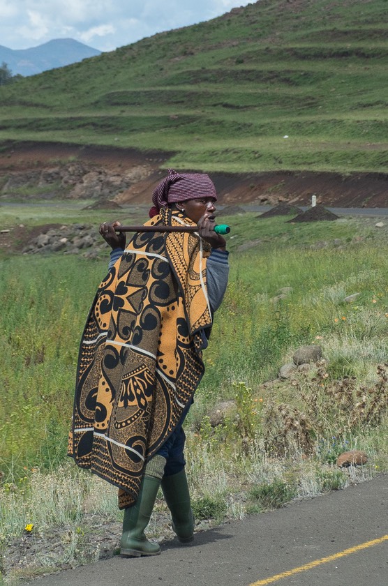
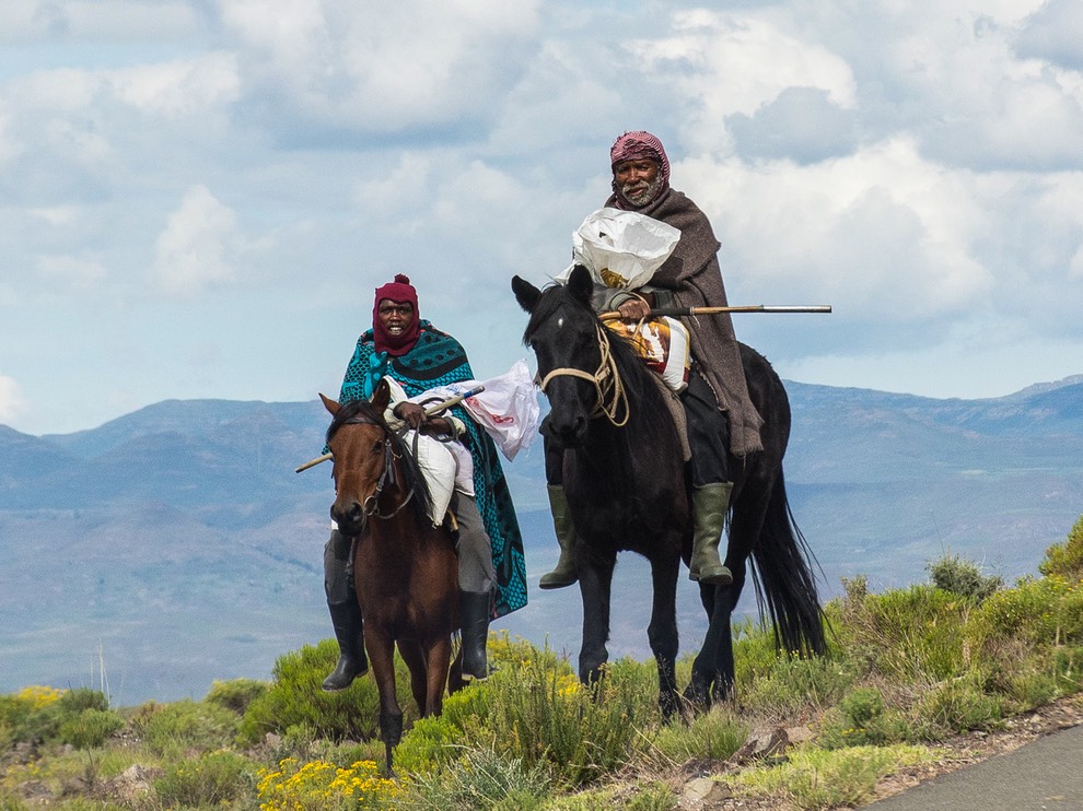
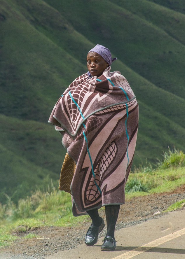
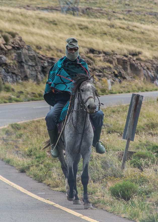
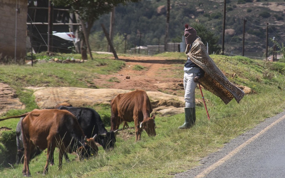
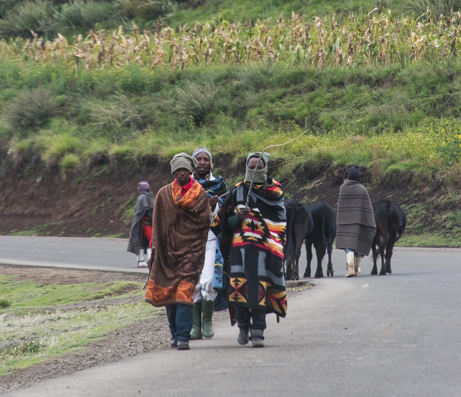
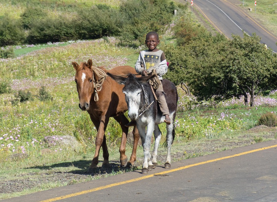
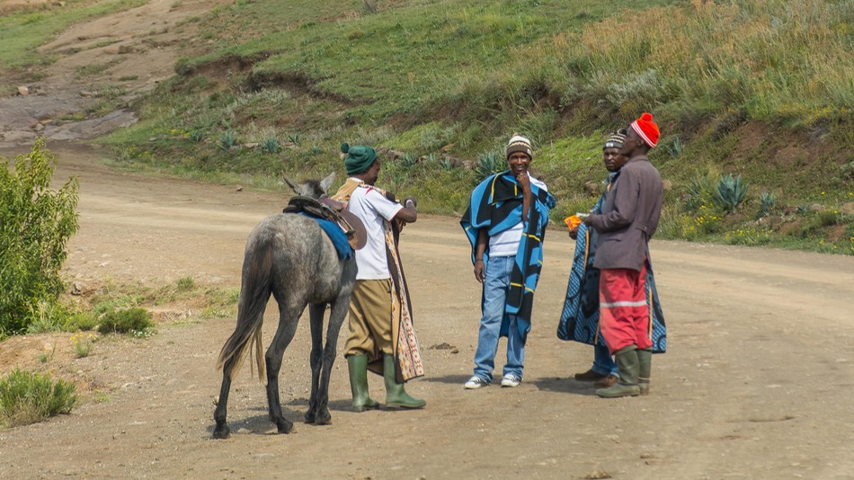
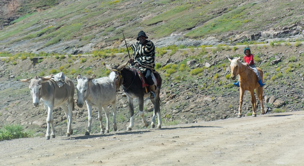
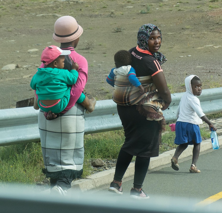
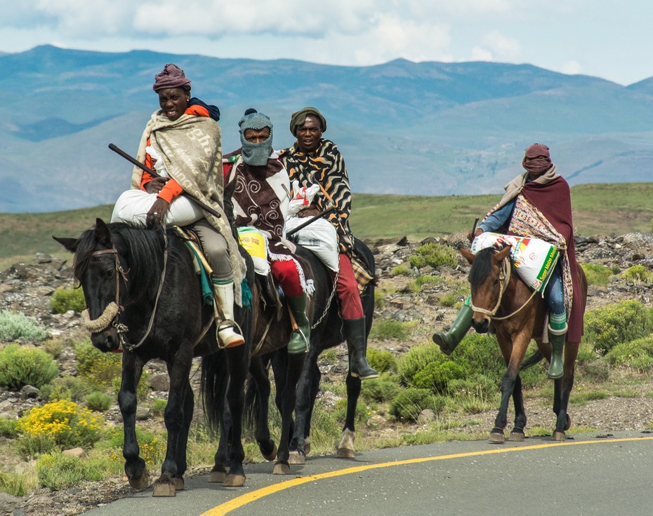
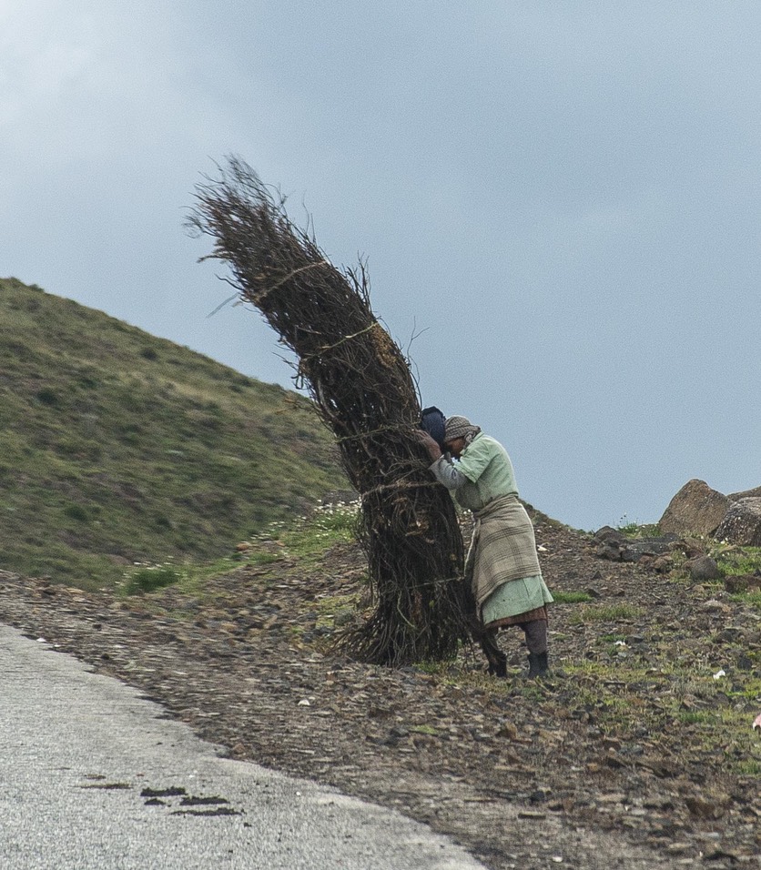
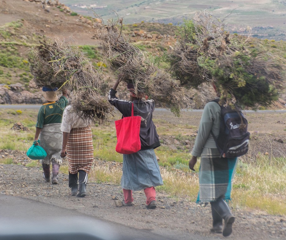
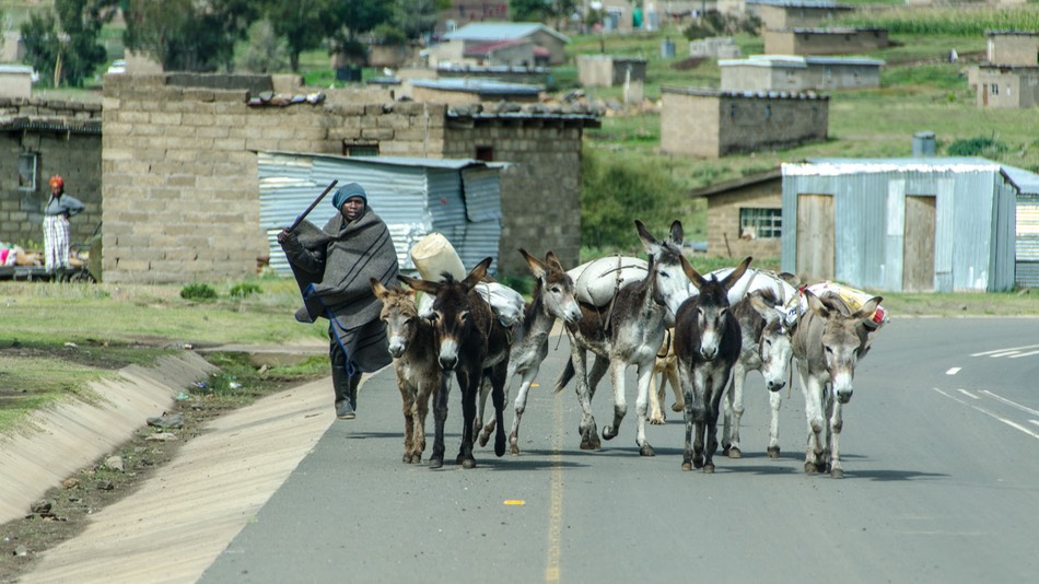
We spent over a week in Lesotho, and would have enjoyed a longer visit. This is a marvelous green and pretty country (at least now, in April), very mountainous, and featuring endless waterfalls and small neat villages. Hiking is one of the big draws but we were there to see the countryside and enjoy the locals. Above all, it is the people of Lesotho who captured our imaginations and our hearts. They work hard in often difficult conditions, yet seemed always ready with a smile or a wave.
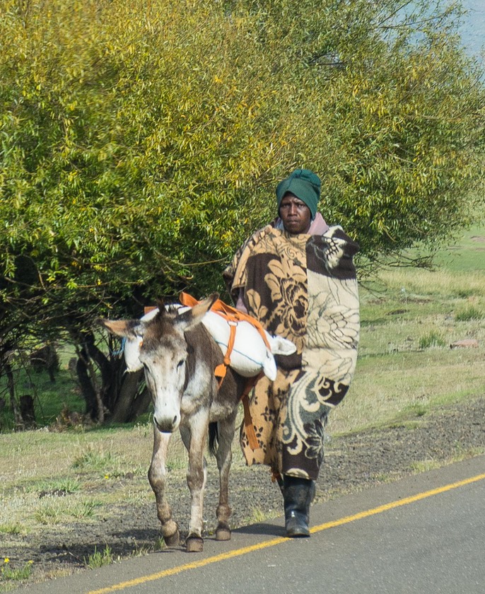
The people are handsome and the native blankets worn by nearly everyone in rural areas are very distinctive, dramatic and colorful. Outside of urban areas, there are very few cars, and folks walk long distances regularly — to get to town, to carry water from the pump, to work the fields and to herd the goats, sheep, cattle and occasional pig. If they have them, they ride donkeys and ponies; the ponies are often also quite handsome. We spotted a few older tractors, but the fields appear to be plowed mostly with either donkeys or cattle. The much different lifestyle, together with the unique traditional costumes, told us right away that Lesotho would give us an enticing new look at life in southern Africa.
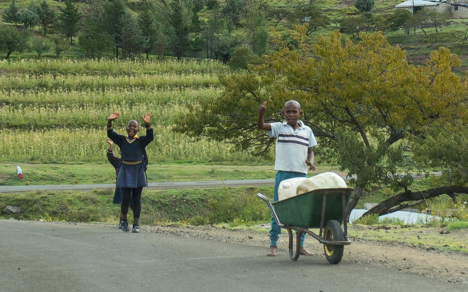
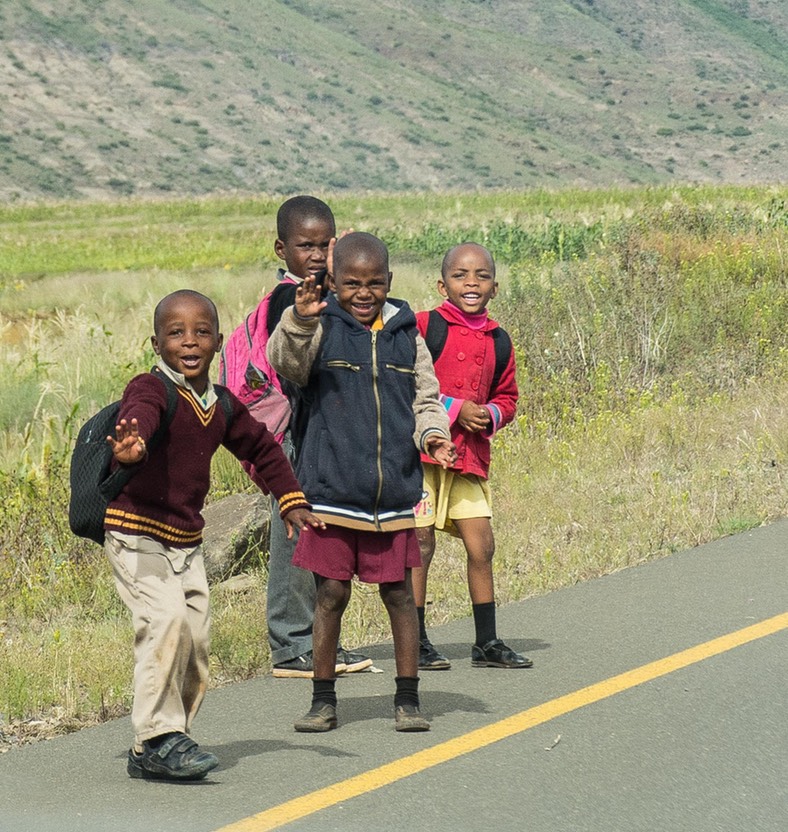
It seems a rough and difficult life, but interestingly, the people we encountered and talked to seem happy and proud. The men, women and children walking along the road (or riding the ponies and donkeys) smile and wave in response to our own waves, and don’t appear beaten down by their circumstances.
Contrary to some other parts of southern Africa, these isolated people seem to be doing fairly well on the contentment scale. Lesotho is one of the poorer countries in Africa, and has one of the shortest life expectancies as well, but you wouldn’t assume that just driving through the villages and past the fields. On the positive side of the ledger, the country boasts one of the highest literacy rates in Africa so perhaps that helps the people appear to be more content.
We spent most of our time in the more mountainous areas, and liked them the best. When you got near a city, or any market town (and particularly Maseru, the capital), you drifted back into mainstream Africa, with more traffic, chaos, trash, and people. Not as pleasant to pass through although people continued to be friendly to us. We have most often found this to be true in all the countries where we have traveled; city life may provide more jobs and higher incomes, but these things always come at the cost of more crowding, higher living expenses and much higher levels of stress.
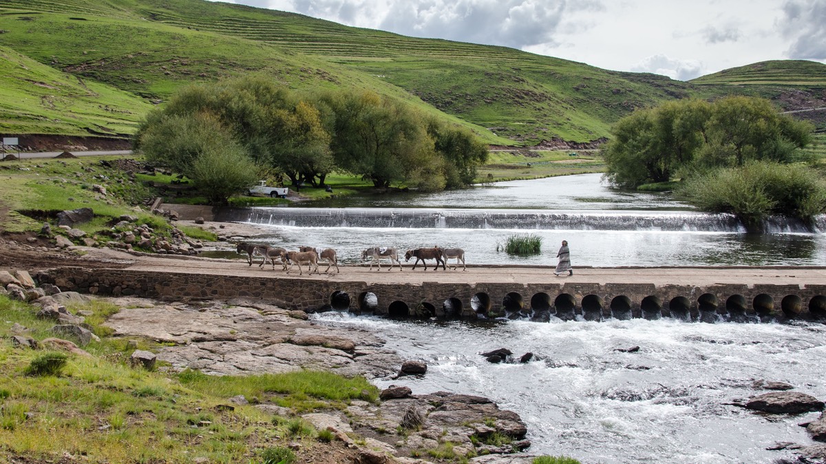
Lesotho has put a lot of effort and money into paving their main highways, and you can travel throughout much of the country without getting onto any really bad roads. This is a real plus, as many of the prettiest areas are enjoyed from the roads winding up and down the high mountains, through lovely valleys and tiny rural communities. The highest mountains and road passes in southern Africa are here, with several passes at above 3200 meters (10,500 feet). Not at all surprisingly, after topping out at the peak, the road would then wind its way down to the next river crossing before beginning the next ascent. It was lovely driving and the paved highway was generally excellent.
Getting into Lesotho is usually a piece of cake as most border crossings are quite peaceful, easy to navigate, and offer few difficulties. While Lesotho does have its own currency, it is tied directly to the South African Rand and Rand are accepted throughout the country. For the more adventurous, however, there are other options. The best known of these is to rise to the challenge (literally) of entering by climbing the notorious/infamous/rough road over Sani Pass, which is only legal for four wheel vehicles. This pass brings you into the country at roughly the southeast corner, within a day’s driving distance of Pietermaritzburg.
The first 10 kilometers of Sani Pass are still in South Africa… and have been under construction for at least a few years (we crossed one nice stone bridge dated 2017). They are planning on paving the road as far as the South African border post. We expect that 4x4 folks will be up in arms when it is completed, as some of the difficulties of the famed crossing will have been reduced. For now, the muddy road, full of construction equipment, accompanying flag-wavers indicating stop/go/turn, the occasional ! sign (our African favorite), a mere 10-km stretch — all on a significant incline — took about an hour to cover. And only then did the real adventure begin.
The next 10 kms between the South African post and the Lesotho border crossing are the fun parts. Dryer and not enveloped in construction, but much steeper, twistier and rockier, this stretch, also 10kms in length took us a mere 100 minutes to cover, so you can easily do the math. We averaged 6km/hour, or less than 4 mph! Now, we readily grant that we are not the fastest of bunnies on rough roads and we were indeed passed by other vehicles. This wasn’t much of a problem, although there was not a great deal of traffic; in many places the road is wide enough to allow for relatively easy passing of cars in both directions as needed. In our defense, the Tiger is larger than the average “Bakkie” or combi-van and does, after all, carry virtually all of our worldly possessions, including the kitchen sink, so we don’t push it on rough roads. All told, it wasn’t the scariest road we’ve been on, but it probably was the roughest and slowest. Tiger takes it all in stride, but it is still a memorable climb.
At the top of the pass (2873 meters) is the Lesotho border post where we got our visas stamped, paid a road tax of 40 Rand ($2.85 US) and got 30-day visas. We noted that the temperature had dropped to 5˚ Celsius (42˚ F).
We now found ourselves on a nice paved road, climbing and climbing and then descending while we enjoyed the new landscape all around us. We had some sun, but also plenty of mists and then rain and wind. There is an old diamond mine near the top that looked defunct, but it could be the Chinese are just taking a breather. We stopped for the night at a wild camp spot along the river down at a lower elevation (only 1998 meters) after we’d dropped down into a valley. Men working with shovels were loading river sand onto old trucks.
We were really enjoying these high mountains. There is only the one road through this whole lovely area, which is actually the western side of the Drakensberg mountains. Though the traffic was not heavy, there were a fair number of heavy trucks. Drivers were quite respectful of the difficulties, as the road was winding and not overly wide, not to mention wet at the time we were passing. We watched a few close calls when big guys were trying to get past each other, and made sure to stay well to our side of the road on tight turns where the trucks needed more room. At one point we maneuvered around a stationary hay hauler that had partly slipped from the road bed — fortunately into the mountain, not over the cliff. Kind of exciting.
We stopped for lunch the next day just below the top of Tlaeng Pass — 3225 meters high, raining and 40 degrees. Highest paved pass in Africa, we think. Then past that ski resort — you know, the one that shows up in the news; the only ski resort in southern Africa. We were up high and enjoying it.
That night we stayed in Mamohasa Campground on the edge of the small town of Motete. Very steep but we were greeted by the welcoming hosts and their even more welcoming dogs. On far hillsides we could see small fires burning near dwellings, and it was rather cold. After getting fuel in Butha-Buthe the next day (now that was some chaos!) we drove south through Ha Lejone. We’d been noticing lots of villages had names that started as “Ha”. Finally got that explained. “Ha” sort of means “the area that belonged to…”. These are very common, and are small communities that do or did belong to an individual family, and have grown a bit over the years.
Our next target was to visit the Bokong Nature Reserve. This was a bit bizarre, and rather lonely; way up in the mountains. No one around, not much info at the information office (but had to pay 30R/person to enter and find this out). Then got sent down below to a new info center — but it was empty, as in there was nothing there! Guides were sitting around offering to show us stuff, but we declined as there was nothing to see — hah. (If we’d paid him maybe he wouldn’t have told us to walk down to the empty info place, but you can’t be sure). All of this aside, it was a lovely spot with a very nice view of the resident waterfall.
Now we were driving south down through the middle of the country, although still high in the mountains. We stopped for the night at another wild camp location in a meadow along the river with a water tap for the locals to fill their containers and to water their beasts. A lovely and quiet night. Next morning we drove past the huge Katse Dam and at this point the road turned to dirt. The weather by now had turned much nicer and was quite lovely; our prettiest day in Lesotho.
It was a nice drive, through lovely country filled with canyons and gorges and green hills. This area became our favorite in Lesotho as the region where we saw the nicest, tidiest villages, with lots and lots of people of all ages walking or riding along the roads, kids playing. It was nice even though the road was a bit rough and slow; maybe we were just spoiled by three days of pavement. We also noticed here that either government or perhaps an NGO had come through and built everyone an outhouse; they were too uniform in size and appearance to have just sprung up individually. It may sound a tad crazy to non-overlanders, but we found ourselves thinking, “we could live here”, it was that pretty.
We thought of staying near Thaba-Tseka for the night, but decided to move on to Mantsonyane — we were starting to get lots of clouds and didn’t have a good stop already spotted. Went back up and up again, over the Pass of the Jackals at 2900 meters. Mostly sheep up here despite the name, with some horses and lots of long vistas. You go straight up to the top of this pass, and then follow the spine of the range for a long distance. It was lovely.
We finally arrived in Mantsonyane, where we knew we could stay the night in the Guesthouse parking area behind the local St James Hospital. It all was a little confusing, but we got it sorted, had a quiet night, and then a nice chat with the lady at Reception early the next morning. She had been quite nonplussed that we hadn’t paid on arrival (Reception closed and locked), and when she showed up in the night, that we were reluctant to get out of bed and come hand her money. But she and I got it handled about 7:15 the following morn. Local confusions.
Upon first entering Lesotho, we’d been in the mountains near Sani Pass, the highest and most remote in the country. As you work your way to lower elevations and closer to the southwest region, you get closer to “civilization.” People are more numerous, a bit more sophisticated, have more money, there are more cars and plenty of larger, more modern dwellings. Naturally we found the area less interesting. We saw less traditional clothing, particularly on the women. Children wore “regular” school clothes. You get the idea; as the scenes we were passing became more mainstream, we started to lose a little interest.
We worked our way back west, heading to Maseru, the capital, where we stopped for a bit, shopping and catching a little wifi, before returning to more remote areas. Maseru was quite normal for a medium-sized city, and even had some modern sculpture. Open-air markets were prevalent, not just for produce but also sheep and cows.
Our plan at this point was to make one more loop through a different part of the country before leaving. First, we stopped for a couple of days in the nice little town of Roma to catch our breath. We found a pretty little garden spot at the Roma Trading Post Lodge; it had been recommended by some friends and was very nice. As a completely unanticipated event, we experienced a sudden hail storm in the middle of the afternoon. Doesn’t seem to have caused any damage (solar panels are vulnerable in hailstorms), but we were keeping our fingers crossed — the hailstones were the size of small rocks and piled up on the grass around us like snow.
Heading south from Roma, we took a very pretty drive through a striking gorge, crossing the Makhaleng River several times at the bottom of the valleys between ranges. We passed Semonkong, a very popular spot that is the jumping off spot for hikes to Maletsunyana Falls, a well known destination. You can get there by pony, too, but only one of us thought that sounded kind of neat, so we moved on.
All accounts had indicated that the road turned to nothing below here; none of our maps showed anything. But no, a brand new paved road presented itself, and we continued further south through a gorgeous area and down/down/down to the crossing of the Senqu River — aka, the Oranje River which we had camped beside in both Namibia and South Africa. Déjà vu, and pretty nifty.
At this point we turned west toward Quthing (aka Moyeni), and the drama continued. This section of road is mentioned in various guidebooks as being quite special. And it was. We entered and drove through a dramatic gorge, followed by a winding (and windy) drive over a 2397-meter pass. Splendid! Down the other side, we spent the night in a little camping area next to the Moorosi Chalets — the only people there, at the bottom of a twisty road out in the middle of nowhere. It was quite charming, barren, and chilly.
The following day we were heading north into a glare sky and through less interesting countryside. We had reached the western part of the country — lower elevations, more open country, more traffic, less interesting people to see and fewer folks working the land — it all looked poorer and was certainly less evocative. A bit boring. We were now on the road back to Maseru, our probable exit point from Lesotho.
But we wanted to see a bit more first. A ways north of us was a turnoff into the mountains again, taking us over the exotically named View of Paradise Pass and leading us to the highly recommended Malealea Lodge. Malealea Lodge is supposed to epitomize the best of the “lodge” experience in these here parts — an African experience beyond compare. We thought we might check it out and certainly would enjoy getting back into the mountains.
We got fuel in Mohale’s Hoek, then turned on to the rough rocky road toward the Pass. That was around noon. By quite late in the afternoon we were still an estimated hour from our destination. It was raining and misty, and we were whupped — that’s an official overlanding term signifying the need to stop for some. We passed a small community with a deserted school area nearby, and quickly decided to give it a shot.
People walking by gave us thumbs up — we should be just fine for the night. But an older man, who lived nearby, with no language between us, indicated that he thought we should move closer to his place. He motioned to a couple of 10-12 year-old boys hovering nearby, seeming to say that he didn’t trust them to leave us be for the night. So we carefully maneuvered over towards a tree that he said would be a good choice. Carefully, because we were now positioned on a significant incline somewhere between two tethered ponies and near a ram that carefully watched us moving around to be sure we weren’t settling upon his favorite piece of grass.
Lots of locals keeping an eye on us for the night! We really appreciated the man who moved us closer to him. We hadn’t felt in any danger. But it was so kind of this fellow to put himself out this way. He indicated he spoke neither Afrikaans nor English; we spoke no Sesotho — no surprise there — so it was all hand signals, smiles, and his caring attitude.
We slept well that night. At some point, late-late-late, we heard him speaking out to a couple of younger voices, which then disappeared. It seems the boys did come round; he must have been keeping guard over us. Sadly, we didn’t see this nice person at all in the morning. We left very early due to our unlevel condition and uncertainty as to possible morning activity at the school. The local taxi van honked at 5:50 am and we got outta there, stopping a ways up the road for a bit of breakfast.
Continuing on our trip through the valley below View of Paradise Pass was stunning; the pass is well named. The weather had cleared and it was a nice morning. After what turned out to be a two hour drive, we finally came to the turn-off to the famous Malealea Lodge, a major tourist destination. A pile of tourists was getting off a bus, phones and vacation clothes on display. We could have gone to see what the talk was all about. But we’d kind of had enough. We’d had a lovely jaunt in this exotic and lovely country, but we were ready to be gone.
As luck would have it, about 10 feet further on up the road we suddenly hit pavement — a nice road, straighten and fast. Our exit strategy stood before us. We put the truck into gear and went on. We would not have wanted to miss the area below Malealea, but it turned out to be a more time consuming drive than we’d anticipated. Coming in to Malealea from the north would be the easy way and probably the way most visitors arrive, but you would miss a lot of great scenery. By noon we were into Maseru, doing some shopping and having a nice lunch at Spurs before crossing the border back into South Africa, which we did by mid-afternoon.
The Maseru Bridge crossing is a small bit of chaos turned into a large mess; at least that’s how it seemed at the time. Nothing was so difficult, but lots of folks going in different directions and lanes that led into parking areas that were too full for more cars. Then there were the long chats with customs folks about the best places to visit in the United States (!). Oh, and having to chase down someone willing to stamp our passports out of Lesotho. All the usual! From there we emerged into South Africa again, and headed a few kilometers down the road to a nice community camping spot in Ladybrand.
We found Lesotho to be one of those magical little jewels we are always on the lookout for. Something out of the ordinary; a place to look back on with a smile whenever it comes to mind. The sense of having traveled through time, of having actually returned to the quieter, simpler existence so many of us claim to long for. It was that evocative, but of course it is never that easy. Still, just as we felt in Romania or Bulgaria, Lesotho reminded us that there are places to be found in this world where folks seem to get along just fine doing without. Without a car, a phone, a computer, the latest styles and trends, even running water and indoor plumbing. How many of us would really choose to live there is one thing, but it sure can make for a nice few days’ drive. We loved it.
Wishing you well,
Rick, Kathy and the ever faithful and capable La Tortuga
You’ll notice that we’ve chosen only pictures of people to include with this message.
To see the beauty of the countryside along with many more pictures of people and animals,
you’ll need to go on over to our Photo Page for this message.