July-August 2020, and again in ‘21
Camping in Wyoming’s Bighorn Wilderness
(updated August 2021)
Here in the USA we will not be doing the Camping Logs we’ve maintained throughout our overseas travel, but we’ve enjoyed our time in Wyoming’s Bighorn Wilderness so much that we couldn’t resist putting together some practical information for anyone who might be inclined to follow in our footsteps. It’s a beautiful area, and if you’ve never been here, you really ought to come. There is something for everyone in terms of camping choices. There are lots of Forest Service campgrounds to stay in, with water, toilets and trash. There is also a huge variety of free dispersed camping locations where you can get away from the rest of the world and be all alone. There are lakes and trailheads and plenty of off-road opportunities. We’ve been here two months and loved every minute of it, and there are still lots and lots of areas left for us to explore. You can read more about our time here in the two stories we’ve posted about the area, Mountain Time, and La Tortuga Goes Boomerang. You’ll also find plenty more pictures of the area on the photo pages attached to each story.
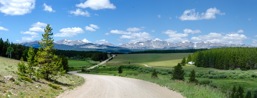
When it’s hot in the summer out west like it has been in both 2020 and ‘ 1, the Bighorn Wilderness makes an excellent destination. The Big Horns is a group of mountains covered in pine forests and open meadows. The roads will take you to elevations that range from 8,000 to over 9,000 feet, while the towns at the base are generally around 4,000 feet. It is that elevation that helps make this a great summer destination as the camping areas in the mountains will normally be about 10–15º cooler than down in the towns. You can approach the mountains from several different directions — the circle of roads between Buffalo, Ten Sleep, Worland, Greybull, Burgess Junction, Dayton, Ranchester and Sheridan form a complete loop.
There won’t be any place to do any shopping after you get up into the mountains, so you need to bring food with you. But in return, what you can enjoy is cool, clean air, plenty of hiking and walking opportunities, stars overhead at night, beautiful mountains to appreciate, and even some animals. We have seen moose, elk, deer and (we think) a coyote. And we also enjoy the small guys: squirrels and chipmunks, an occasional rabbit at lower elevations and of course the birds. It goes without saying that this territory is often shared with small groups of cows. They don’t bother you, but they sure are curious as to what you’re doing in their back yard. The more isolated the area you are in, the more likely you are to see all these critters.
The highways into the wilderness, US14, US14A and US16, are nicely paved and very scenic. Traffic is generally light and the condition of the highways makes periodic runs into town for supplies quick and pleasant. The Forest Service Campgrounds are never far from the paved highways, while the roads leading off of the highways to take you through the dispersed (wild) camping areas are gravel. The main unpaved feeder roads are in very good condition and there are plentiful dispersed camping areas just off these main roads. Any standard vehicle on its own should be able to manage them quite easily and towing is not an issue. Each one of these main roads has many smaller off-shoots going further into the forest and further away from “civilization”. These secondary roads are often rougher, occasionally much rougher. If you want to be able to explore these areas, you should consider your rig’s capabilities, and decide accordingly. Clearance issues can be important, as well as overall size and whether or not you are towing. It is often recommended that you drop any towed vehicle before taking off into remote areas.
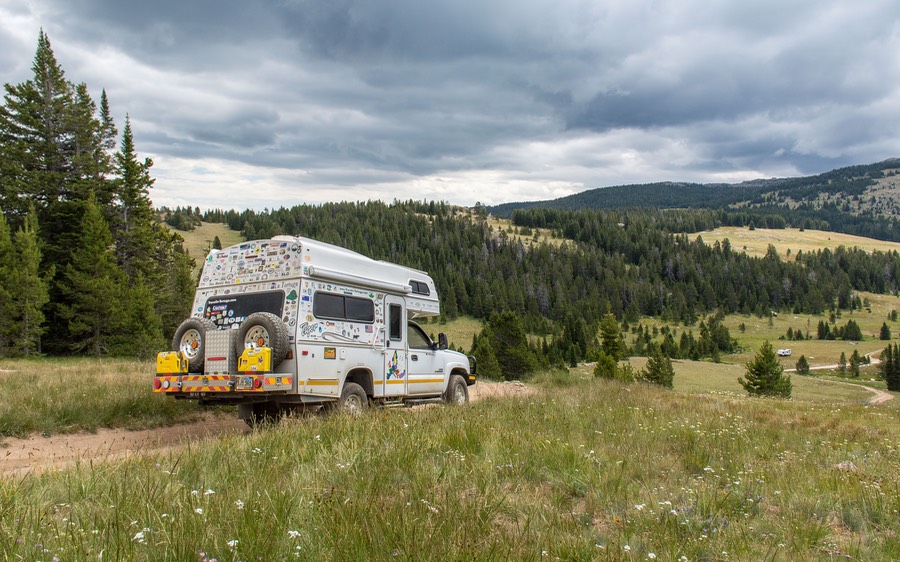
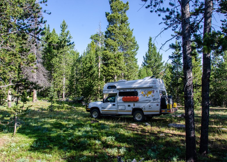
We’re often asked about our vehicle. The Tiger is a 2007 Chevy 2500HD truck with a Duramax diesel engine and the living quarters permanently mounted on its back. It is roughly 20 feet in length, has the standard ground clearance of a stock 4x4 Silverado, and the configuration of the Tiger together with the ARB front bumper maintain ample approach angles at both front and rear. It weighs 10,500 pounds, and runs on standard sized 265x75x16 All Terrain tires on Alcoa aluminum rims. Tigers are built in Columbia, South Carolina.
Our Tiger is sturdy, and we have had no trouble with it on American roads. As mentioned above, any standard two wheel drive vehicle, including most RVs, will have no trouble accessing camping areas in the Bighorn Wilderness. If you are comfortable driving your RV, whether van, camper, motorhome or trailer/fifth wheel, on average two-lane secondary roads anywhere, you will be fine in the Bighorns. As always, however, the more you want to venture off on your own to get away from other campers the more you will appreciate a smaller and more capable vehicle; specifically one with greater ground clearance.
We chose to concentrate on dispersed camping areas here in these mountains, as it suits our lifestyle the best. We really love wandering down an isolated road, spotting a small meadow and finding a place to hang out for the next several days; we don’t make reservations and don’t like being locked into formal camping arrangements. Our rig carries enough water for about a week, and our small refrigerator does almost as well. At the end of this article is information on each of the places we camped.
We did not stay in any of the campgrounds in the Bighorn Mountains, although we drove around in several. They all are typical Forest Service campgrounds, nice and clean, and are well regarded among folks we’ve talked to who have stayed in them. They are sized for smaller vehicles, have water fill points — generally a hand pump, not a faucet — toilets and trash bins. They are reasonably priced in the $17 to $19 per site range — prices from 2020 — and half-price with a senior (for US seniors) or annual (for everyone else) camping pass. Officially, all require reservations, according to the signage; possibly not always necessary, but each of the campgrounds we wandered through seemed pretty full and reserved cards were present on many empty sites, so plan accordingly.
We’ve all been hearing about how busy American parks and camping areas are this summer, both public and private. Definitely true. Locals we’ve chatted with say they’ve never seen so many people out and about. One woman told me their town and surrounding area had been amazingly busy starting way back in April. The Bighorns are no exception; a very nice lady at the Forest Service office in Buffalo estimated there were about three times the normal number of folks out camping in the area this season. This is one reason why we’ve been so interested in getting away from the main areas — to be off by ourselves, which was our main goal for this social distancing summer. Sometimes we’ve had to work to make it happen, but in the Bighorn Wilderness it has always been worthwhile. One of the great things we can report about the Bighorns is that even in this busier than normal summer we never had any trouble finding spots to camp. Sure some areas were pretty busy and we moved a couple of times if things got too noisy for us, but another spot was always available nearby.
If you’re thinking about heading here, it would be good to stop at a Forest Service office when you get in the area. We visited the Buffalo Field Office, on Highway 16 just above town (1425 Fort Street) and they were very helpful. they have a map that shows all the roads (with FS numbers) in the Wilderness, can discuss with you which roads your rig will be comfortable on, and make suggestions for places you might enjoy the most. Other towns with resources will be Sheridan, Lovell and Worland for sure, and perhaps others too.
So, where have we been and what did we like the best?
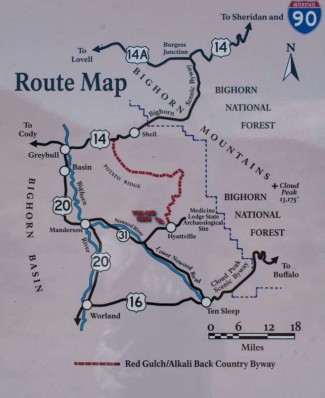
There are three large areas we checked out. The first is the area off Highway 16 between Buffalo and Ten Sleep; the second is the section off FSR 26 that runs west from the Sheridan area to where it comes out at the west side of the Wilderness and meets Highway 14, coming up from Greybull; the third is FSR 15, which parallels US14A and runs west from Burgess Junction to the western edge of the Wilderness where it then drops down out of the mountains and heads on towards Lovell. Now, you aren’t going to know these areas without a map, but they are three great opportunities to explore sections of these mountains to your heart’s content. We enjoyed all three, and below you will find specific information on how to find every place we camped.
We spent the most time along the roads off Highway 16 as it travels between the mountains above Buffalo and the canyon road that drops down into the town of Ten Sleep. There are six or eight major gravel roads going off 16 on both sides of the highway. We explored and camped along Circle Park Rd, the Elgin Park Loop Rd, and Pole Creek Rd. Ultimately, we found this part of the Wilderness the most rewarding and lovely. For instance, we camped a total of 5 times along Pole Creek Road, spread between two different places. We really like being in the forest but on the edge of an open glade so we can get lots of sun for our solar panels. Our favorite, about half-way along the length of Pole Creek, gets sunshine starting about 8:00 am and lasting until late afternoon, has deer, chipmunks and squirrels — and about a dozen cows that come through every couple of days. We think they’ve decided our truck is a hay wagon; they stand around for a half-hour or so, fantasizing that we might throw out a few flakes, then give up and go on. We are at 8500 feet, about 30 minutes out of Buffalo, and far enough from large meadows that there’s little traffic.
Further north in the Wilderness is the dirt road (FR26) that goes from the Sheridan area west to meet US14. It also goes through nice country, although it is more open than the US16 area — more meadow than trees. There are several lakes and reservoirs in this area, and it is very popular with off-roaders. We had a couple of nice days alongside Park Reservoir, but were regularly putting up with ORVs zipping back and forth and kicking up dust, so we finally moved on. At the western end of this road we took a side road (quite rugged) and found our perfect glade a mile or so further in.
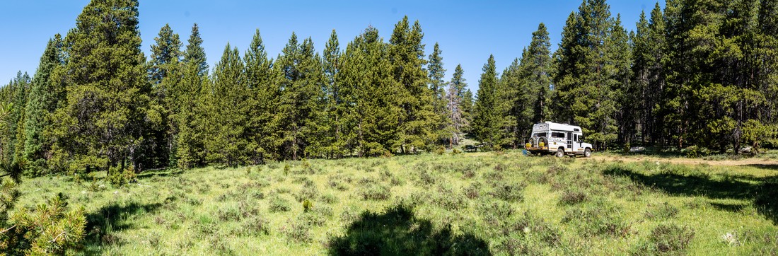
We also wanted to spend some time up off US14A, on FR15, which runs east and west across the northern part of the Wilderness. And we found an absolute jewel. We wandered off into an open area, a large knoll with several small rock formations. We came to a halt, smiled, and didn’t move again for almost a week. At 9100 feet, we didn’t do a lot of hiking, but did take some lovely pictures.
If you’re up for a fairly long dirt road trek, Hwy 49 going north from Ten Sleep and through Hyattsville is lovely. This road is called the “Red Gulch/Alkali Back Country Byway and is really worth the trouble in a capable vehicle. The road quality varied from excellent to somewhat rough, and got quite slippery at one point when it rained. Still, it takes you into beautiful country and connects with Hwy 14 at the big bend in that Hwy where the road turns from east-west to north-south. One of our highlighted campsites below is at this bend.
Practicalities:
Shopping: Each of the towns we’ve mentioned above has some grocery shopping available. Sheridan is the biggest by far, as it is a regional center, so it’s a good choice. Some of the smaller communities, such as Ten Sleep, can hardly be called towns at all (but in Ten Sleep you will find a great library and Dirty Sallys for wonderful ice cream). We like the town of Buffalo the best, but maybe because of the scones at the excellent Reese & Ray’s (now Lynn’s) IGA store there. What we have found works best for us is to stop in a town, shop, dump and fill, and go to the library for internet; then head up into the mountains again. Sheridan is best if you need to find someone to do some work on your vehicle.
Libraries: In order for us to stay in touch with the outside world, libraries have been essential in Wyoming. For many years, we have used a T-Mobile hotspot on our phone in order to gain internet access. This has worked marvelously in many countries around the world. Sadly, not so well in the Mountain States. (Verizon and AT&T are better choices here.) And nothing works well in these mountains, anyway. So, for us the short term answer has been to make use of the excellent public library system in Wyoming. Each town we have wandered through has been very good to us. We’ve spent many hours catching up on email and the news (and often staying longer than necessary because of the very pleasant air conditioning). We have spent time at the libraries in Sheridan, Buffalo, and Ten Sleep and all have been excellent.
Water and Dump: The Bighorn Wilderness is well prepared for lots of activity, and for campers of all sorts. The campgrounds are numerous and they have plenty of facilities. For the rest of us, sometimes you need to sort out the facilities you need. To us, water and dump are the most important, and the Bighorns were ready for us. There are two large public spots set aside to meet our needs, each with four dump/water stations — plenty of room! One of them is at the northern edge of the Wilderness, right next to Burgess Junction, where highways US14 and US14A split. The other spot is on the south side, along US16 at Leigh Creek, just after you have gone over the Powder River Pass and are getting ready to drop down along Powder River Creek and into Ten Sleep. Probably the best public dump/water stations we’ve ever used; and yes, they are free, but do accept donations. They are the only ones we’ve found up in the mountains but there are also water/dump locations at fuel stations in Sheridan and Buffalo, and further west, in Powell. (See below for details.)
Elevation: One other practicality that needs a moment of your time. You may be noticing that there are high elevations in this discussion, and lots of ups and downs. The Bighorns are a large massif, with plenty of peaks and valleys. Just like the Black Hills of South Dakota, but higher. So you need to think about your rig and any limitations it may have for climbing and descending long grades. If you are towing, be very sure your trailer brakes and brake lights are operating properly. There are some long, steep climbs and drops, although the highways are excellent, with great signage and lots of brake cool off turnoffs. They also have plenty of passing lane opportunities so traffic won’t back up behind you. Really terrific highways!
Boondocking Locations in the Bighorn Wilderness:
1) Along US Highway 16, into the mountains from Buffalo:
Buffalo area. About 11 miles out of town, going west up Highway 16, is a lovely ridge with a good gravel road going along for perhaps a mile, ending in a trailhead with a gate, a turnaround, and a private road going off to the right. It’s a wide saddle, with room for many rigs to park off the gravel road, with lots of space between, and plenty of room to get well away from the highway passing below. Very nice views of the mountains above, breezy, and cool unless the breeze goes away. No services, except quite decent phone connection; actually cell service here is better than down in Buffalo. We've spent several nights parked there, along the ridge. It’s a little hard to spot the turn away from the highway, but, going west from Buffalo you will first pass the sign entering the National Forest on your right, then a truck pull-off and brake check area on your left, then, directly opposite an unmarked pull-out on your right there will be a small sign indicating a left turn to Grouse Mountain Trail Access, and a dinky little red signpost saying #8203 (useless, and hard to see). Coordinates at the entry are N44.32950, W106.86996. Super, super! The specific camping area changed from ’20 to ’21, apparently due to where they want the cows to graze at different times. In ’20 we camped in the first section, before you reach the gate, but on returning in ’21 signage indicated no camping in the first mile, which takes you to the gate; and then a sign on the gate just says to keep the gate closed but does not prohibit entry. There are always other campers so you’ll see where other people are. Good spot!
West of Buffalo. Spent 2 nights out Circle Park Rd; from town take US16 about 23 miles, then turn right (FSR 20) for a couple of miles on a good gravel road. This road eventually ends up at the Circle Park Campground, but before you get there we found plenty of open ground; elevation 7980 feet (N44.28260, W106.96361). All vehicles should be able to get to this area. Beyond where we stayed (and still before the campground), the road gets rougher in places. We didn’t drive further; however, there is a beautiful meadow up that road about half a mile, for a nice hike. We saw moose at this location. Downsides were lots of ORV traffic, and when we were there we could hear lots of shooting a little ways away. Can’t say whether this was a one-off event or if there is some sort of shooting facility up the road.
West of Buffalo. We stayed for several days along the Elgin Park Loop Rd/FR22, a little further along off US16. We found a beautiful spot for ourselves at (N44.26831, W106.90190) and stayed several days. To get there you go past the Elgin Park Trailhead and keep going. The trailhead is in a very large open area, and should be reachable without difficulty. We settled there first, but this was July 4th weekend and it got too crowded for us. Beyond that point, to our little spot, the road was a bit rougher, but not bad. This spot is suitable for small vehicles only. Elev. 8067 feet.
West of Buffalo. Pole Creek Rd/FR-31, off US16 can be reached from two different points along US16. It’s a loop road that starts almost directly opposite the turn onto FR22 into the Elgin Park Loop Rd (listed above). A bit hard to find a spot along the Pole Creek Rd loop, as this area is very popular in the summer. But a lovely area. We drove about half of the length of the road before finding a place, but it was just perfect, 5.7 miles from where we left US16, at (N44.18719, W106.97126,) enough distance from the road that noise from the very limited traffic was not bothersome; on the edge of a very private meadow. The entry to the meadow is narrow and down a bit of a rough incline. But if you take it slowly, all should go well. There is room here for a couple of small rigs, and it’s very private. We stayed here 3 different times, several days each time, and it’s probably our best choice in the Bighorns. Deer, chipmunks and squirrels. Elevation 8420 feet.
West of Buffalo. West from town on US 16, we also explored Pole Creek Rd (FR 31) starting from the bottom end of the loop, where it rejoins US16 west of Lost Cabin Campground. About 1/2 mile in we came upon a large meadow (8495 feet elevation) with lots of camping opportunities. There was plenty of open space, and we parked at (N44.14891, W106.98116). Stayed several nights, and enjoyed it a lot. We came back again a few weeks later, but soon found that this time there were large numbers of ORVs nearby that were using an area close at hand for a playground. So we moved on. Still a nice area, especially mid-week.
Nearby, on the other side of US 16 and a mile or so to the east at the turnoff for Hwy 3 is a different meadow area we found in 2021. This area seemed less crowded and with fewer OHVs, although such comparisons are difficult to make based on one visit. Still there are fewer offshoot roads on this side of things and in looking at both the FR 31 meadow and this one at the same time, this one was definitely less crowded. Coordinates are N44.14499, W106.91994.
2) Along FR26, west of Sheridan:
West of Sheridan. West from small town of Big Horn, near Sheridan, on Rd 335, which soon becomes FSR26 and then turns to gravel. FSR26 is a nice, very scenic, mostly good road that cuts all the way across the mountains to Hwy 14, which it joins approximately 8-9 miles south of Burgess Junction. We followed 26 up into the Bighorn Wilderness; the road climbs steeply and quickly, then levels off. We turned south on FSR 293, the road to Park Reservoir, and found a place to stay along the water, (N44.54971, W107.21457), at 8371 feet elevation. This is a very busy area, filled with ORVs and motorbikes, and overused; quite dusty. Would be better off-season; still the reservoir was pretty. There are many side roads and both dispersed camping and campgrounds. Stayed 2 nights. Note that in this area, the roads branching off from FSR26 are not as well maintained as the dirt roads along Hwy 16 out of Buffalo. These roads were pretty rutted and require more ground clearance than some vehicles will provide.
West of Sheridan. West from small town of Big Horn, on Rd 335, which becomes Rd 26 and turns to gravel. Continuing west from Park Reservoir area (above), back on FSR 26, about 2 miles before it joins US 14 we took Woodrock Rd (FSR 231) to the left, and followed it until we found a lovely, isolated glade at 8796 feet which was set off a bit from the road (N44.68815, W107.46205). This is a rough mountain road with plenty of rocks and run-off damage, not suitable for large vehicles or those with limited clearance, but the ORVs love it (but they were very polite going past us). We stayed four nights and it was beautiful and quiet. This spot is more easily accessed from the US 14 end where it is only about two miles in and the road condition is a bit better. Half way between where we stayed and US14, the road levels out and opens up and there were many camping spots that would have allowed us to get further off the road, be more level, and have the option of more sunshine. For us, we prefer our isolated glade, but others may prefer the open area, which was quite crowded when we passed.
East of Greybull. East of town for 26 miles on US 14, right at the point of the very sharp turn where US14 turns north to Burgess Junction (which is roughly 18 miles further on), there is a small gravel road (marked FSR17) that turns east off the highway, and then immediately comes to a T-junction; take the left fork; it climbs into the hills for a very short distance, perhaps a quarter mile. You come out into an open field with a lovely glade of trees (and its own stream) on the western side (N44.57014, W107.53085). Very nice views, free dispersed camping area with several fire pits. Suitable for smaller vehicles only and a bit difficult to get level. One of the nicest places we have stayed in the Bighorn Wilderness; we stayed 3 nights. Picked up free wifi at the Bear Lodge Resort in Burgess Junction when we moved on. Elevation 7668 feet.
3) Northern side of the Wilderness, off US 14A onto FR15:
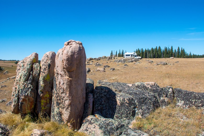
West of Dayton. Go 26 miles west of town on US-14 to US-14A at Burgess Junction; bear right on US-14A, then continue roughly 18 miles to FSR14 (Sheep Mountain Rd); turn right and enter large open camping area. We traveled a short distance and then turned left onto a small road that immediately split. Left went to FSR13 (was marked Fortunatus Summer Home Group); we angled off to the right and up into an open meadow area with no trees but lovely rock formations. Very breezy, which kept it cool. Camped at 9170’ elevation (N44.81485, W107.82087); this is a large open area with other camping opportunities within view, and it does have a campfire ring. Stayed 7 nights. One of our best spots.
Dump and Potable Water Locations:
Burgess Junction is a wide spot in the road on US14 along the northern side of the Wilderness, about 26 miles west of Dayton; this is where US14 and US14A split. The large dump station is off the road a short ways, at (N44.77383, W107.51730). There is free wifi available at the nearby Bear Lodge Resort, in Burgess Junction.
The similar Powder River Pass location is on US16 along the eastern wide of the Wilderness, about 2 miles west of the pass, at (N44.16025, W107.11048).
In Sheridan, there is a free dump station at the Visitor Center, I-90 exit 23. You go under the freeway and up the hill a short distance into the facility. There is potable water at the dump; also lots of trash facilities. Also in Sheridan, the Holiday fuel station off of Exit 25 on the south side of town has dump and water, and is among the least expensive fuel stops in town.
In Buffalo, there is a CENEX station a short distance from I-90 exit 58, turning into town onto Hart St; free dump and potable water; on the right. This is a particularly nice dump area; very roomy and always clean. The station also is often the least expensive fuel in Buffalo.
If you have questions please send an email to us at rick@travelin-tortuga.com.