September 2008
What’s a Nice Place Like You...
Doing on a Road Like This?
Ecuador Part 2
Or…..The best roads are the worst roads. We have continued our exploration of the roads of South America and are happy (?) to report that the further we go the more poor roads we see. But that’s not all bad! Small, out of the way places that seem not to have changed in the last hundred years are just our style. And you can find them in spades in Ecuador. We’re really having a great time.
But I digress….when we last spoke we were in northern Ecuador. We had traveled back to the north to see what we had missed by heading straight to Cuenca as soon as we entered the country. We’ve told you about our visit to Otavalo and the surrounding area.
Returning to Quito from the Otavalo area, we spent most of another week in the city. We really like Quito, as we have said, and enjoyed ourselves. (Other than the traffic.) We got haircuts, real haircuts (the first in about a year), found a great DVD place so we could stock up on movies. One drawback there – we should have had him put each of them up on the screen for us. Too naïve, I guess; we ended up with a couple that would only play in Spanish. And by the way, those haircuts? We spent a total of $12.00 on them – for both of us. Green with envy?
We spent lots of time at Uncle Ho’s restaurant, enjoying the super wi-fi and food. I discovered their coffee, the best I’d had in town. I finally asked about it. I was told it was local, and that they got it from “the coffee guy at the open market.” I bought some off them, and we are enjoying it now. It’s kind of hard to find Ecuadoran coffee around here; it seems most of it is exported.
While we were in Quito we decided to modify our plans for visiting the Galapagos Islands. We originally thought we’d go next year, not wanting to spend that much money so soon after our trip to the States in May. But in checking with the travel company with whom we were making our arrangements, we realized it would be much more expensive next year. Costs were going up for starters; in addition, we would (probably) be flying back to Ecuador from far away, ratcheting up the numbers yet again. So, final upshot is that we will be flying back to Ecuador from Lima, Peru in September and starting our trip to the Galapagos on September 28.
One amusing sidelight to these arrangements is that we got out our trusty packet of Dramamine, which we had brought with us when we ran away from home in 2001. We wanted to make sure it was still good. Well, it wasn’t even good in 2001. It had expired in 1987! Needless to say, it is no longer with us…
Finally finishing our chores, we beat feet. We found an easy way out of Quito going south, and hit the road.
Our plan was to do circle loops to the west of the Panamerican Highway as we moved back down towards Cuenca and southern Ecuador. We had two loops in mind; they turned out to be spectacularly good choices and we enjoyed ourselves tremendously.
As we traveled south, it seemed greener than it had as we’d gone south before. As we passed through and around the smaller cities south of Quito, we were reminded of the ugly new American-style housing we had seen in this area before. Not charming, not pretty, but lots of it. But the mountains were green and cool.
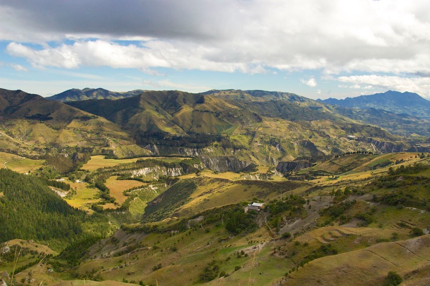
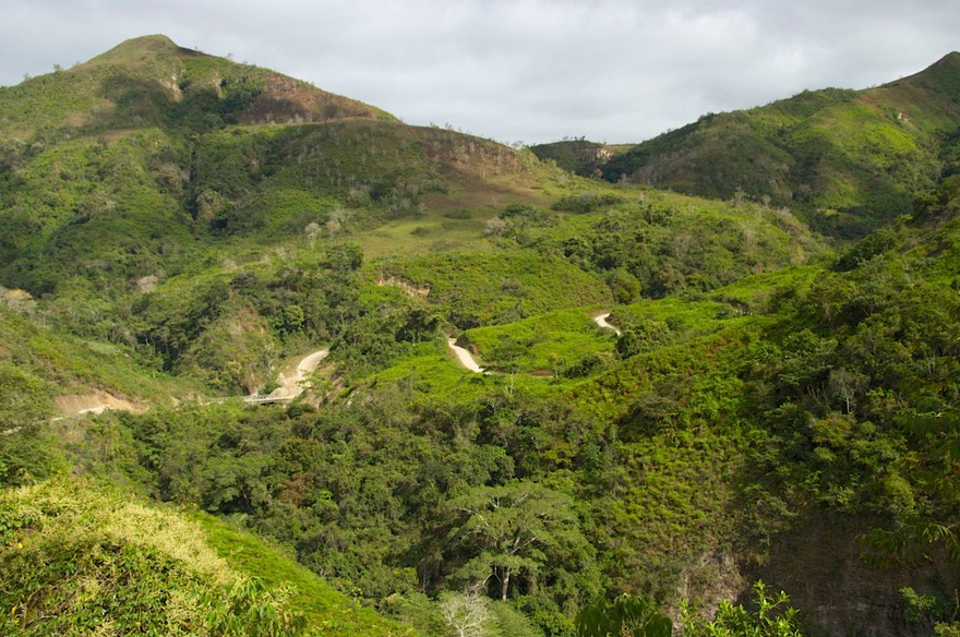
We intended to visit Cotopaxi National Park, but took a pass because it was all socked in. A ways further south we started our first circle route to the west, known as the Laguna Quilotoa loop. Very quickly you climb much higher into the mountains than the Panam travels; before we knew it we were at 13,100 feet, and we could still see the highway below us. The views were incredible. We went over the tree line and the land became totally barren. All we saw were sheep and guard llamas; it was very stark, and about 45 degrees outside. There were donkeys and small thatch shelters on the hillsides; and lots of cactus (Huh? Yep!).
The road was a series of thin S-curves, and then we came into clouds and couldn’t see a thing. This would be the normal routine as we moved back and forth across and between mountain ranges. It would be dry on one side of the range and then wet on the other; foggy and then clear. We saw lupine at almost 13,000 feet. The folks we encountered along the road looked as windswept as the landscape – permanently ruddy-faced.
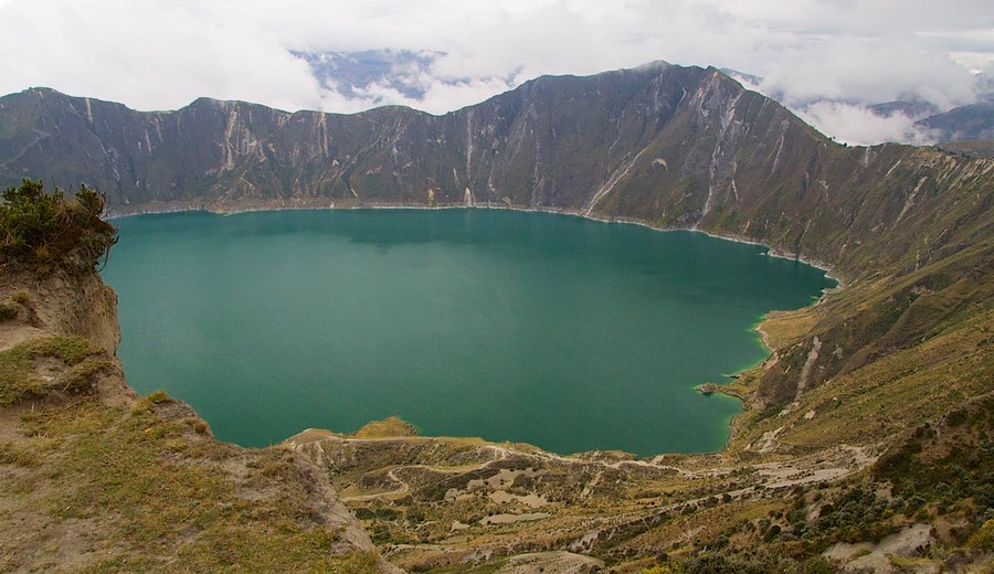
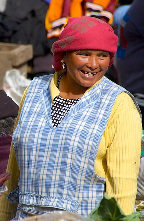
We spent the night at 12,700 feet, at Lago Quilotoa, a large crater that would have reminded us of Crater Lake in Oregon if it had been prettier and not so stark. But it is, indeed, a huge crater and was quite interesting. There were plenty of opportunities to purchase local handmade items; however, the area was so windy I felt really bad for the people sitting there trying to attract our attention. We heard our first Quechua spoken here.
In the morning, we spent some time chatting with backpackers who had stayed at one of the hostels on the edge of the lake. They were preparing for a strenuous day’s hike, but filled with enthusiasm. We were just as happy to drive off in La Tortuga! We promised to give them a lift if they got too tired.
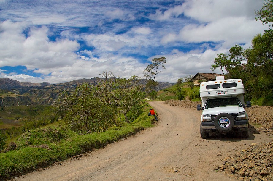
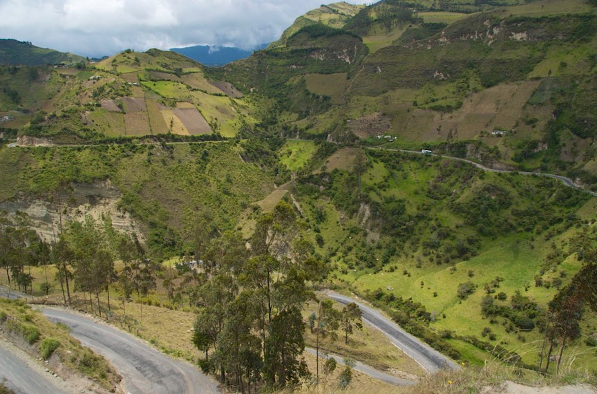
This is an incredible drive we are taking! The vistas are stunning, and constantly changing. From Lago Quilotoa we dropped to 8300 feet, and now we are back up again. We have seen decent views of Volcan Cotapaxi , not entirely covered by mists. Ecuador has great volcanoes, but they are so tall they make their own weather. (Remember Denali, in Alaska? Same thing.) It’s hard to get good, clear views. The road takes us over 14,000 feet. Rick was reminded that in California, Mt. Whitney is about 14,000 feet. This is not your father’s California! We are above the crops, above the tree line, at the “just living” line. The road is sometimes good, sometimes lousy, but always spectacular.
We ended up our loop back on the Panam, drifting further south. Our next “detour” would take us up and around Volcan Chimborazo (the highest in Ecuador at over 20,500 feet), down almost to Guayaquil on the coast, and then back through the mountains and Las Cajas National Park, ending up in Cuenca.
This second loop was even better than the first one. We decided to start a little later in the day, as we awoke to rain and heavy fog. We hoped to outwait it, in order to see Volcan Chimborazo. Eventually, about noon, we gave up and started along.
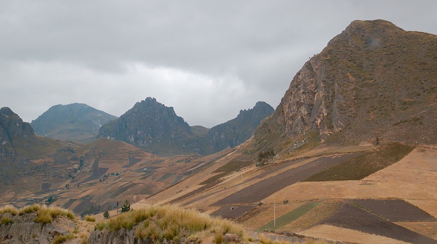
As we rose higher in the clouds, we noticed how rich the soil was, and that the patchworks of cultivated land were as high at 12,500 feet. Above that elevation was only tundra and grazing animals; very little was being grown in the ground. We saw horses and sheep and lots of llamas. We drove higher and the countryside became a dry and barren moonscape. At the top of the pass (13,800 feet) we were able to get a brief glimpse of the mountain (it sure was cold to be taking pictures – 42 degrees) before we plunged into the pea soup fog going down the other side.
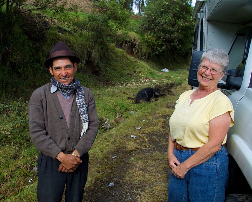
About halfway down we started looking for a place to stay the night. We turned off at this funky sign talking about an historic park for the old village of Bilovan. It had a statue of a Spanish soldier on top of the sign; we were intrigued, and thought to check it out. The small town of Bilovan was friendly and charming, and we drove through on our way out toward the museum. The views got better and better. Suddenly the road died. Washed out. So we turned around, found a quiet spot beside the road and settled in for the night. Before long a handsome old gentleman stopped to chat, assured us we would be fine there for the night, and recommended the view. We had a pleasant, quiet evening and night.
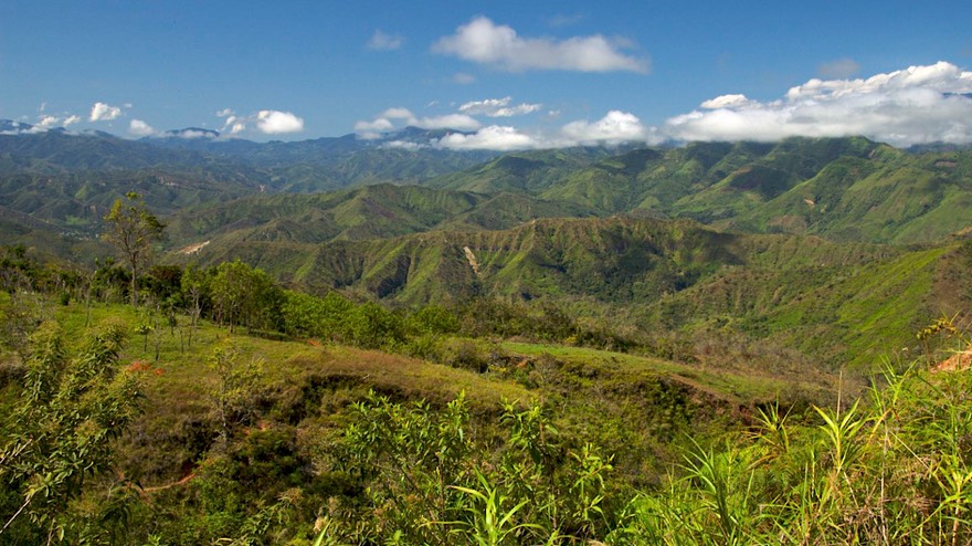
The next day everyone in town waved us goodbye as we headed back for the highway and the trip on down the hill. As we dropped lower, we went through banana plantations. Suddenly we were at 2,000 feet and changing into shorts for the first time in weeks. By the time we’d been on the road for two hours we had dropped 8000 feet (it was only 25 miles – of very bad road) and we were at 326 feet (we would finally reach a low of 37 feet on the day).
We were in a huge floodplain, with large fields of rice growing everywhere. The workers lived in houses on stilts along the edges of the fields; they were on stilts because they were actually in the water. What a way to live! This seemed a very poor looking area; we stopped in a town to buy some fruit and folks sure didn’t look very “kempt.”
We went south a bit, skirting to the east of Guayaquil (the largest city in Ecuador), through the town of Milagro, before turning east and back into the mountains. We left the floodplain at 12:45; by 1:30 we were at 6600 feet and by 2:20 back to 13,600 feet at the top of the pass (and it had dropped to 39 degrees). In about 24 hours we’d dropped from over 13,000’ down to sea level and back up to over 13,000’ again. Whew, glad we don’t have to walk!
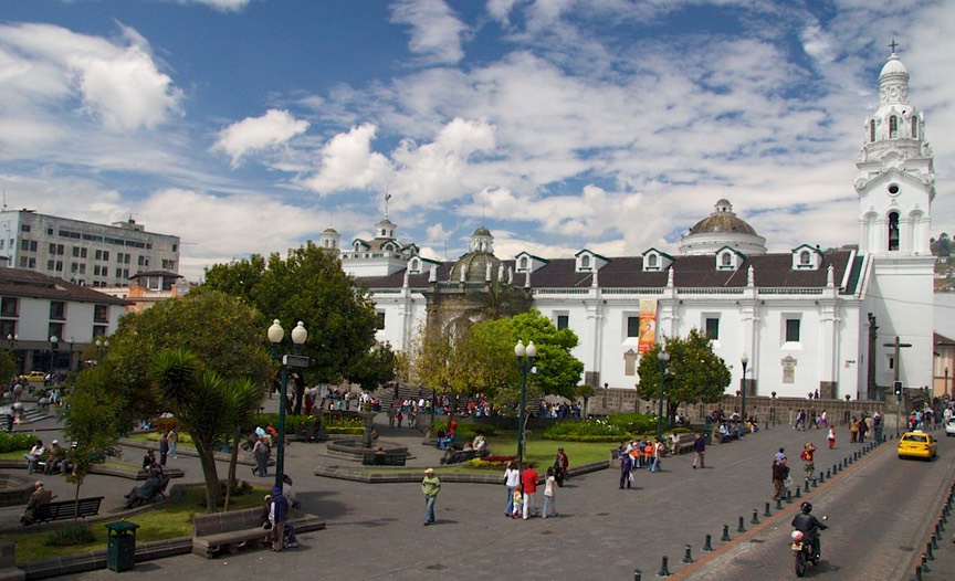
We were quite pleased to be back at a higher elevation, even though we were, once again, in pea-soup fog. We were glad to be on this road, which was delightful, and actually in pretty darn good shape. We ended up back in Cuenca before nightfall, and settled back into this town we’d already spent considerable time enjoying. Coming into town we were reminded of what a lovely mountain valley setting the city was in; it’s easy to forget when you are simply negotiating your way through it; Cuenca is in a beautiful spot.
We stayed in Cuenca for several days while we waited for mail from the States and took care of a lot of business stuff. Cuenca is a delightful city, clean and pretty, and with lots of interesting things to see and do. It has some lovely rivers running through it. Not just rivers, but greenbelts alongside. Places to take children (and graze both horses and cows), walk, sit and read, hike. A real delight.
On Saturday, Ecuador and Bolivia were playing as part of the preliminaries for the World Cup (soccer of course). The whole town went bananas, with flags and shirts and banners and ribbons and silly hats. And when Ecuador won the party went on all night. It was great fun to be part of.
Ecuador is, by the way, the home of the Panama hat (go figure). And Cuenca has several factory/stores that make them, along with a Panama hat museum. While we were taking care of business, we also did a little shopping. Our lifestyle doesn’t put us where “tourism” takes place very often, and it was delightful to be in a shop with hats for sale, hats to be “made to order,” and people to wait on you. Panama hats make Rick look like a pinhead, unfortunately; too small perched atop his big self. They look gorgeous on the ladies, however, and Kathy found one that she liked a lot!
We finally left Cuenca and headed for the Peruvian border. Friends who had traveled north from Peru into Ecuador recommended a border crossing in the mountains due south from Cuenca, and we were quite intrigued. They said it was a rough crossing in wet weather, because the road is rough, the border is right at a river, and it is quite steep on the Ecuador side. At least there is a bridge there now; used to be only a ferry. This, until the late 90’s, was disputed territory; the two countries went to war and even now the maps say the crossing is “ill-defined” – you tell me what that means! The river hasn’t moved, just who owns which bank?
We decided to give it a try. We wended our way down, down, past Loja, the last major city in Ecuador, where we stocked up on everything we could think of. (We had heard that Peru was not well provided with “goodies.”) We ran into a Swiss couple coming into town, and camped with them, enjoying the chance to compare notes. They are headed directly to the Cordillera Blanca in Peru; we may catch up with them there, as they have planned a 3-week trek into the mountains.
Our route was splendid. We went up and down the mountains, through stands of pines and eucalyptus, with lovely vistas of green whenever the clouds gave way, into drier areas and then back into the wet at the southern tip of the country. Down here the mountains are lower, but very pointy and sharp. We were on good paved road as far as the town of Yungana, then it was good dirt. We were pleased.
We got lost going through each and every town. We’ve decided there are no directional signs in these countries because the folks love to stop and chat with you. Very friendly and helpful, but on their terms. This worked fine until we got to the little town of Zumba, a ways above the border but the last outpost of civilization (they even have an airstrip). We were lost, lost, lost; the entire town was torn up for repaving. Finally got sort of out of town and found ourselves on the airstrip. No problema; no plane coming in. But wait, there’s a car in our faces; he’s honking, making rude gestures at me as I ask directions of a little old man; so fine, we’ll get out of his way; the old man and I exchanged rueful glances. And the guy in his car was middle-aged! What’s a 64-year-old lady to do? No, I didn’t return his gestures, but I coulda…..
As we got closer to the border the road got worse and worse. We decided to hang it up for the night, and camped beside a pretty stream, gathering ourselves for the next day. And it got steeper (as promised), and rockier (ditto). But we did okay, and ended up arriving at the river in good shape amid a rare burst of bright sunlight.
The crossing wasn’t difficult, very laid back and pleasant. Large military presence, reminding us of the recent conflict. (But the Ecuadoran soldiers walked across the bridge to the Peruvian side to eat lunch at the café there; it least these guys are all friendly again.)
The road deteriorated further as we entered Peru; dirt for a long time, then bad road, then, finally, good solid pavement. We scurried on our way, looking for new and different adventures
We really like Ecuador, although for a long time we kept comparing it to Colombia. There was a division of the house: was Ecuador a cut below Colombia, or just a step behind; was Colombia more lush and beautiful, or was Ecuador more rugged and dramatic. We continue the discussion, but totally agree that Ecuador is a great spot to visit; we recommend it to you. The countryside is full of great mountains, interesting sites, delightful and friendly people. There is a significant indigenous population that’s industrious, successful in the open marketplace, and doing a fine job of maintaining their traditions. If the government continues to improve the roads and the lot of its people, there will be no reason for Ecuador to take a back seat to any other country. As with all these countries, of course, a change in government can have enormous side effects; but for now at least, Ecuador is a great spot to travel.

And, as we have said, Ecuador has been a cheap place for us to visit. Fuel is practically free, provisions are inexpensive, and other costs are in line. But we don’t travel the same way most visitors do; we sleep in weird/free places, we don’t eat out much, we don’t buy souvenirs, etc. So I asked a friend who had been here as a “regular” tourist; his experience was very similar to ours. Their hotels, tour packages, eating in fun places: all very inexpensive. And they rave about their trip; isn’t that cool! Nobody doesn’t like Ecuador!
On the flip side, I spent some time chatting with the owner of Uncle Ho’s Asian Food Restaurant in Quito. He said the costs of doing business are high; everything has to be shipped in and it’s very expensive. And when something goes down, it’s down for days, due to a lack of trained personnel. So there are downsides.
A side note: in Ecuador, as in every other Latin American country, those with an eye on international events are taking great interest in our November elections. We had interesting discussions with people in many different walks of life.
And, oh yes, driving here is as bad or worse than other countries; I have a quiz for you….
1) When do you know the light is green? A) When someone honks to tell you to get going.
2) What does a left-turn signal mean? A) Well, it could mean a bunch of things; usually it means it’s OK to pass, but watch out, sometimes it actually means an upcoming left turn. It’s a lot like “fuggedaboudit”, which, if you’ve seen the movie Donnie Brasco, you know is kind of an all purpose word for wise guys. Sometimes this… sometimes that… who knows?
3) How come roundabouts don’t work in Ecuador? A) Because the drivers have no discipline; they don’t understand the concept of taking turns.
But, (4) When you’re on a lonely back road, the sight of buses coming at you means the road is open and there’s room for us to get through!
And just remember the old song “Beep, beep; beep, beep; the horns went beep, beep, beep.” Their horns work, even if their brake lights don’t!
So, Ecuador? A great time was had by all. And we’ll be back in a few weeks to visit the Galapagos. More on that later!
From our house to yours, Rick, Kathy and La Tortuga, on the road in Peru.
Click the link to see more photos from Ecuador.