September 2008
We Left Our Heart in Leymebamba
Northern Peru
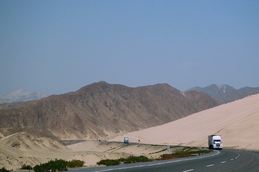
Peru is proving to be an amazing adventure. We never expected this as the country sometimes gets a bad rap from other overlanders. Other than Machupicchu and Cusco, you might think there isn’t much here. In part this might be because most people enter along the Pan American Highway, which travels the coast from one end of the country to the other – a coast that is Peru at its worst. This coastal area is literally a desert, nothing but sand dunes and a total of 1 ½” of precipitation a year; and for half of the year, like now, is generally covered with a steady overcast and gets very little sun. Being the major highway, it is naturally the home of the big trucks. We were more fortunate, or more wise, take your pick.
We cannot give enough credit to those who have preceded us in our South American adventures. We owe them a huge debt. They have come here from many other countries and have visited South America in both clockwise and counterclockwise directions. They have traveled many a small, dusty road and have visited places you’ve never imagined possible – and they write about it: in blogs, on websites, in messages sent home to friends. One couple, Don and Kim Greene, has even written a book, recently enough that the material in it is quite valuable to us. (Most books are either in a foreign language or were written so long ago that they are not overly useful.) We try to gather as much of this material together as we can, and from these postings we create our own route. It would be so much harder without the writings of those who have gone before us.
The Greenes have become friends. They are American, and are currently in Europe, having shipped their rig over from Baltimore. They are headed for Senegal. Try that one on for size! We met them in Guatemala, and have stayed in touch ever since. Their book, Americas Overland, is great. The point of this discussion is that Don and Kim encouraged us to enter Peru by a different route than that taken by most overland travelers. And we are so delighted they made the suggestion.
We crossed from Ecuador at this small military post on the Rio Blanco in mountainous southern Ecuador. We are always startled at the stupid questions asked at any border: “Where are you going?” is the most frequent. Where the hell do they think we’re going? To the next country, of course! We happened to cross into Peru on September 11; didn’t have any significance to them, natch.
It was a beautiful, clear day, the first in quite awhile, and we were jazzed about our route. Immediately the land started to flatten out, curiously. Were we heading toward the coast, in spite of the map? We knew that the Peruvian coastline was very flat, dry, and boring, and were working hard to stay clear of it. We finally figured out that we were close enough that the geography was indeed influenced by proximity to the coast. Soon we entered a long, green valley (at about 1800 feet) filled with large rice plantings. Folks grinned and exchanged waves with us (we always do a lot of waving; it seems to break the ice); the countryside was very pleasant. We were now following the Rio Chinchipe, which provided plenty of water for the agriculture.
The road was pretty bad, and we were glad when it turned to dirt for awhile. More rice, joined by bananas, palm trees, mangos and coconuts; then lovely pavement: striped! With signage! Now going 40 mph! Awesome! Yes, Peruvian roads are supposed to be pretty good; our first was truly splendid!
The first town we hit was a rude awakening from the serene and quiet last several days we’d spent in Ecuador. Jaen is a market town and regional center, full of bikes and tuk-tuks buzzing around at top speed and disregarding all the normal rules of the road. There was a festiva underway and the entire town was mass confusion, including a brass band marching around the central plaza that said “Virgin of Macarena” on the big bass drum. We did a little shopping, grabbed some internet, and beat feet out of town.
By the way, the noise wasn’t our only rude awakening in Jaen. You may remember that fuel prices in Ecuador had been very low; well, not so in Peru. Back over $4.00/gallon for diesel again. Sigh. This, of course, was the main reason we were now back in tuk-tuk and motorcycle land. Far fewer cars on the roads.
We tried, leaving Jaen, to avoid a certain amount of backtracking in order to get to our road into the mountains, and so followed a line on the map that looked like a shortcut. Ah, no. It took us into a little town, Bagua, that was supposed to lead to Bagua Grande and would put us on our way. Buzzer sounds; no; pick another door! Road washed out, bridge not working, whatever. So back we go, back through Jaen (buzz, buzz), and finally got to our right road. Oh, but one delightful, new Peruvian experience. In Bagua, asking for directions of a handsome older gentleman, I immediately got a kiss on the cheek, a smile, and then the delivery of the discouraging news that we would have to turn around. Yes! Absolutely worth all the lost effort! (Wasn’t the only kiss on the cheek I was to get in Peru, either.)
(Two other ways to know we were now in Peru: the men whistle as they ride along on their horses, just for their own enjoyment. And…in the towns and cities, for traffic control (?) the cops use whistles. So, much noise!)
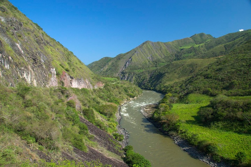
Out onto the right highway, a lovely road, we followed the Rio Utcubamba as the valley narrowed and we began to climb. We drove up a magnificent canyon, increasingly dry as we left the broad valley. As the canyon walls closed in on us, the GPS kept getting lost and beeping at us. Poor fellow!
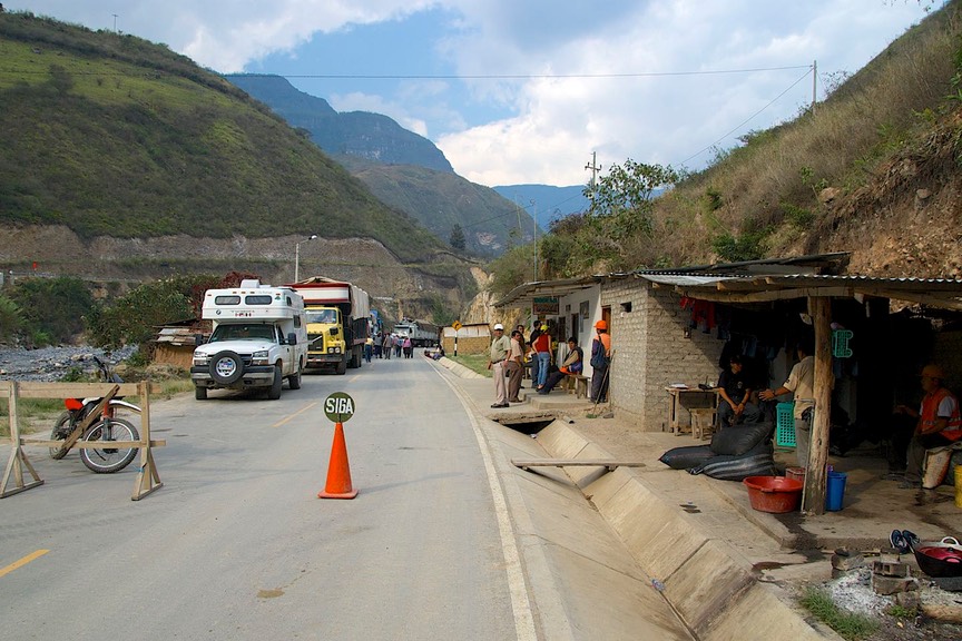
We ran out of daylight in Pedro Ruiz, where we would turn off the main (beautiful, paved, clean) road and head for Chachapoyas, the site of some relatively unvisited ruins which interested us. After a quiet night along one of the town plazas, we headed south, made our turn and started climbing higher. Then, hmmm, a roadblock. It was 9:15 am. Road closed until 4:30 pm. Blasting and working on a section washed out by spring floods. Well, okay. A forced day of rest. No big deal; we always have so much computer work to do that a day off is a blessing. At 4:15 all the vehicles in line started up, the blasting/repair crew came by going the other way, and off we went.
And what an incredible, stunning ride we had. This is truly remarkable country. Steep canyons, fast rivers. We were still following the Rio Utcubamba, and went right through the area where it had torn away the entire road and much of the rock canyon that supported it. The road crews were working had to repair the damage, and to keep it from being repeated, blasting huge sections of canyon back from the roadbed. Quite a sight.
We found Chachapoyas a remarkable place. We spent two nights camped on the square (the Plaza de Armas). Now these were not quiet nights, mind you. That’s because in Peru the plaza is definitely the center of action for the townspeople. The squares are almost always lovely, with many plantings, trees, and benches. There is a constant flow of activity, from (very) early morning until well into the night. But, to our surprise, there isn’t much screaming/shouting or unpleasant activity. The folks are simply out and about, enjoying each other’s company or hurrying across the square to get to their destination. There were even art classes taking place during one day. It was truly delightful.
We felt part of the community; people would stop to check out the rig, ask a question if we were in sight, show their friends where Peru was on the big outside map (or point to somewhere they had been). We were definitely part of the scene.
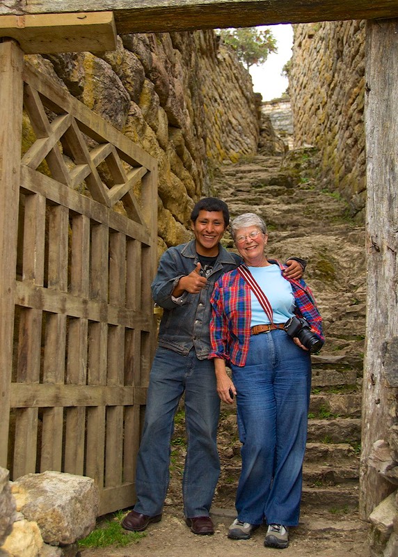
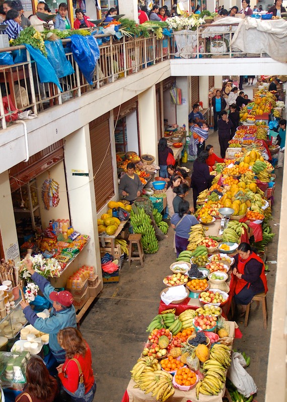
Chachapoyas is a market town; it had an enormous covered produce area just one block north of the square, as well as many nearby stalls selling everything under the sun. We wandered and enjoyed. We also (unusual for us) hired a guide to take us to the Kuelap ruins that were about 2 hours away. Our information was that the road was too, too terrible to drive; as it turns out we would have been just fine, and would recommend the drive to anyone with reasonable clearance.
But the ruins were truly cool and Augusto, our guide, was just great. We had done the right thing. He spent 3 hours with us (some of it in a drizzling rain) showing us the importance of this fortress, both to the Chachapoyans and then to the Inkas who eventually overpowered them. By the end, we really understood what had happened here, and how the two cultures became intermingled. It was a magnificent site, on top of a ridge, and quite fascinating. It is suggested in the guidebooks that Kuelap is second only to Machupicchu in grandeur, but that while the much better known ruin sees 2,500 visitors per day, Kuelap sees about that number per month. Indeed, on the day of our visit there were perhaps a dozen others present.
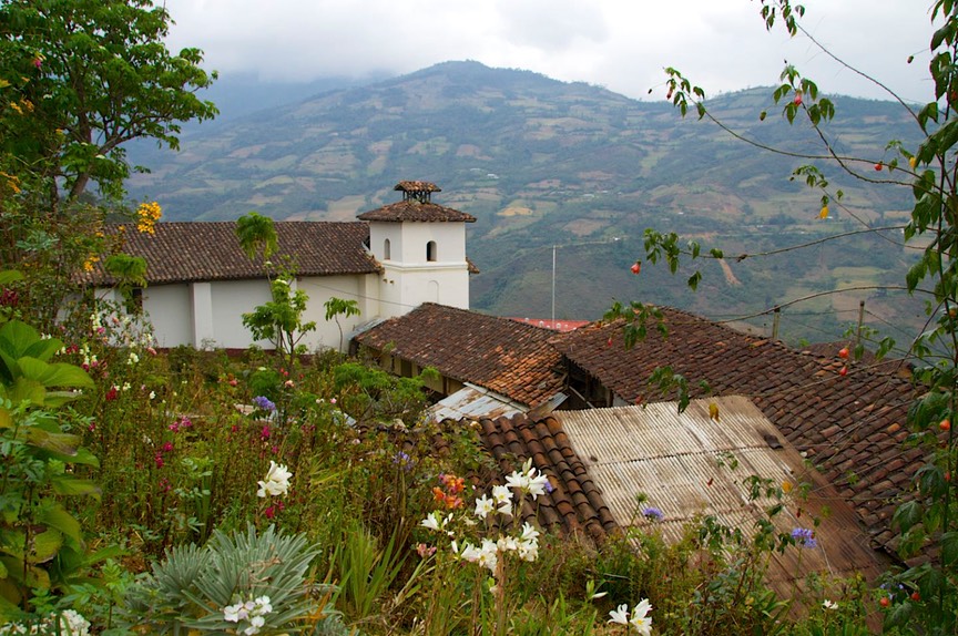
Chachapoyas sits high above a lovely valley. The day after our ruins adventure, we moved on, glorying in each hour on the road. It was so beautiful; we were at about 8,000 feet; trees were in bloom, the hillsides were green, the fields were being cultivated. What not to like; a stunningly beautiful area.
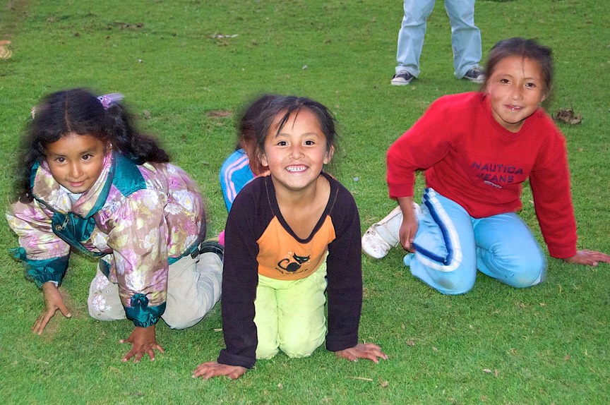
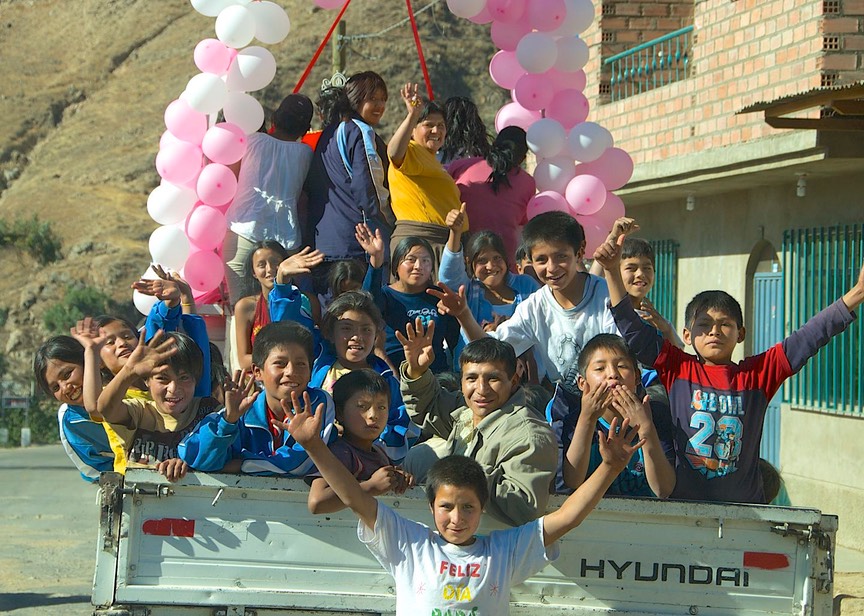
We drove to Leymebamba, where we wanted to stop and see a museum of the Chachapoyan culture that had been constructed by the townspeople. We arrived too late to see it that day, but Celita, at the museum, sent us part way back down the hill to an area of homes around a soccer field. There were cows and horses grazing on the field, and people visiting with each other as they crossed to their homes. We spent the night there, and again became a part of the community. We were surrounded by children as they came home from school, and then again in the early evening; we got out the cameras and they mobbed us as we took picture after picture and showed them to the kids. It was great. Parents came looking for them for dinner, which was fortunate, as it was getting dark but they didn’t want to leave. Moms and dads finally hauled them away and we settled down for our dinner, too.
We really did leave our hearts here, and hated to leave in the morning. But Celita had promised to open the museum early for us, knowing we had a long journey ahead of us. She gave us a tour of the museum, which has several important collections. The building itself is stunning, supported in part by the Austrian government and one of the nicest museums we have ever seen. It contains khipus and mummies along with other relics. The khipu is a series of knotted strings dangling from a cord, and was used for record-keeping and history telling by the Inka; they are tremendously valuable and fascinating. The mummies are even more fascinating; the Chachapoyas did not embalm their dead, but managed to choose burial sites which would preserve the remains. These mummies came from a burial site which is accessible, and we wondered whether we should have gone there. But, the best of the best were right here in the museum; dozens of mummies in a glass enclosed room, absolutely fascinating. Amazingly enough, the museum was established as a result of the discovery made just in 1997 of the site where the mummies had been stored for five hundred years. So many archeological sites down here have been desecrated either by the Spanish conquistadors or latter day grave robbers that this find and the resulting museum are truly special. As you can see, we were enchanted with this area. If we have any opportunity to revisit the mountains of northern Peru, we certainly will; perhaps next year.
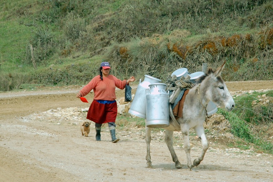
At this moment, however, we are quite unfortunately very aware of the time passing too quickly. Our plans to visit the Galapagos Islands are intruding on every decision we make. There is nothing worse than having a commitment you cannot break. We needed to be in Lima, in order to take our flight to Guayaquil and on to the Galapagos. So on we went, up and up and up over the mountains (11,800 at the top), into fog and rain, before dropping down into the depths again. At these elevations, we were surprised at how much dairying we saw. Apparently this area supplies most of the dairy products for the entire region. As it was still morning, we saw many burros with large milk cans strapped on each side, trudging to the collection points. Some of them were being herded, but many seemed to know the way all by themselves, and were just walking along with no owner nearby.
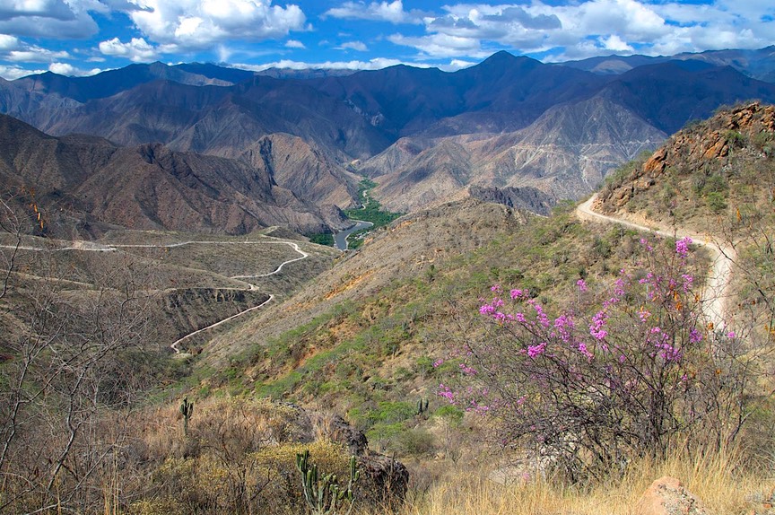
We were on good dirt road, and were on a well-known route, heading for Cajamarca. This road would take us down to the bottom of the canyon through which travels the Rio Maranon; at its lowest point we would be down to 2800 feet, at Balsas. Here we would find real desert, with lots of cactus; it reminded us of the Baja in Mexico. And then, 2 hours and 57 miles later, we would be back up over 10,500 feet. Quite a canyon, a wonderful winding road and quite a day!
Still on good dirt road, we spent the night in Celendin, in a pretty valley that was back down into trees. But then, shortly after we left town the next morning the road turned really (I mean really) bad, and it stayed that way all the way down to the coast (the next day and a half). It was beautiful country, but really difficult driving. Apparently the government is preparing to rebuild this road, as we saw convoy after convoy of trucks carrying huge equipment heading up into the mountains. We think it will take several years, but future travelers will certainly appreciate it!
We finally reached the Pan American highway, which runs along the Peruvian coastline. As we got closer, there were large rice fields along the bed of the river we had been following. Again, we saw how poor the people were and what a dismal life it appeared they were leading; hopefully we were wrong. At the coast, we turned south. We were giving up several interesting museums along the north coast, but felt our time would be better spent if we started south toward Lima, as we had a big detour we wanted to make, to visit the Cordillera Blanca.

The Cordillera Blanca was an area we refused to skip. These are the highest mountains, the ones covered with snow. We weren’t going to hike them, but we wanted to get close enough to enjoy them. We had email friends we wanted to catch, and they were in Caraz. This was a very strong incentive. And Lima was calling (sigh).
So we trucked on down the Peru coast. Mile after yucky mile. Dry, sandy, full of wasteland (some of which was actually being farmed – in the sand), and very boring. Other than the crops, it reminded us of the Mojave Desert. At Santa we turned up into the mountains, on Highway 12, following the Rio Santa. And soon it got better again. We climbed and climbed, through rugged and dry mountains, on a very rough, dirt road.
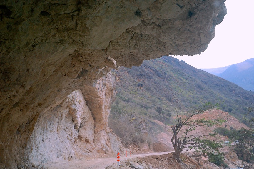
We began going through rough tunnels in the mountainside; soon we were in the famous Canon del Pato. All told, there were almost 50 tunnels (according to others’ reports; we were too busy to count!). The road continued to be dirt and gravel and not really two lane’s width. Some of the tunnels were short and you could see daylight even as you entered. Some of them were multiple; you’d finish one hole and promptly enter the next. Some had bends so you were clueless as to what was next. Usually there was a short pull-off just before you entered a tunnel, in case someone was coming at you. There were rules. If you were in a tunnel, you apparently had priority (we had to back out of one because of oncoming traffic); you were supposed to honk before you entered; if you were little, you were definitely the underdog. It was a bit unnerving, but quite do-able. The tunnels had been created by Duke Power, who had built a dam here and needed access. At one point, we were following a work truck, as it abruptly signaled and then made a left turn into what we thought was solid rock; abracadabra: the rock had a gated opening which swung wide to let them in!
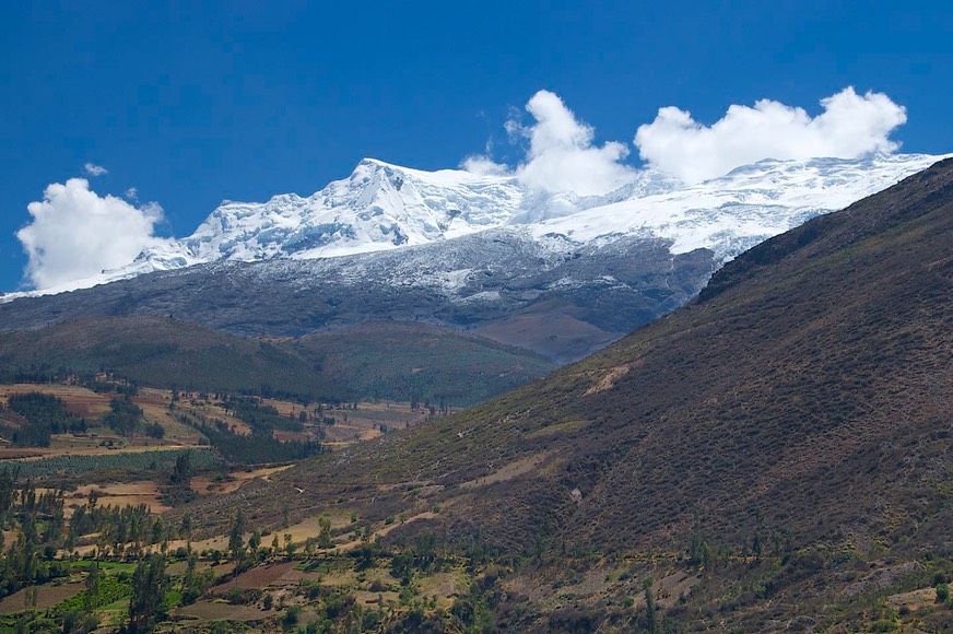
Emerging at the end of the tunnels, we were in a lovely valley and then soon into the mountain town of Caraz, with an incredible view of the snow-covered peaks above. We found our way to the Los Pinos Hotel, where we met up with Doug and Stephanie Hackney. We spent two days sharing experiences and travel tips; they were moving north (and we were going south, of course) so we had lots of “goodies” to exchange. They are now in Ecuador; we hope to meet up with them again next year some time.
We hated to leave the Cordillera Blanca; there were several roads and sites we wanted to investigate, but if we didn’t head back down to the coast, we were going to miss our flight from Lima. (When we planned our trip to the Galapagos, we thought we had plenty of time to do and see all we wanted before we would have to get to Lima. We were so wrong; we should have scheduled the trip to start about two weeks later.)
So we kept on. Our road took us south from Caraz through a fertile valley with jacarandas in bloom (March in September), through Huaraz which was in the middle of a parade (floats decorated in pink, with pink-clad princesses on top), up over a pass at 13,500 feet, and then turned west and started down toward the coast.
At the top it was very barren; the entire area, including snow-capped peaks, reminded us of Wyoming and the Grand Tetons.
Coming down toward the coast, now on a really lousy road, we came upon sugar cane, cornfields, avocadoes, chilies and bananas. Despite the road through a canyon very dry except for the river, it was a lovely day, following a pretty stream, in bright balmy sunlight. All true, until you got about 25 miles from the coast.
Then the garua hit.
Garua is the gloomy fog-haze that settles over the Peruvian coast for about half the year. It includes occasional mist, but mostly just dry cloud cover. No sun. Lima is famous for it. We drove down the coast and into Lima, found the hotel where we would stay and leave La Tortuga while we flew to the Galapagos, and started packing for our flight. And you know the rest!
Rick, Kathy, and La Tortuga
Click the link to see more photos from Northern Peru.