February 2008
Guatemala
Every car for itself and watch out for the Big Rigs!
aka: Frogs for Peace. (?) See below!
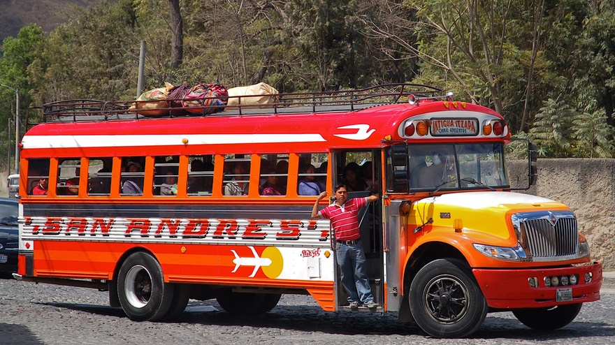
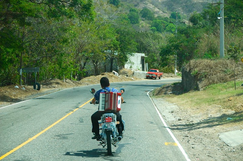
We left you on the border into Guatemala. We had an easy crossing (January 29) and then headed into the mountains, reaching a delightfully cool 8,000 feet in altitude before we stopped for the night. This was soooo great: we had been sweltering for weeks, it seemed. The next day, we topped out at 9222 feet. The road was good and we enjoyed the views. Being motorcycle people, Rick was interested in what the locals were riding. In Mexico it had mostly been small street bikes and scooters, but here everyone was on dual-purpose bikes, mostly lowered to fit the shorter people. The road was better than what we had been used to in Mexico, built to a higher standard; but contrary to what someone had said, we were still having to deal with topes, called tumulos here (speed bumps in the little towns, if you are unfamiliar with this term). The drivers, as promised, are more intense than we have previously seen. And the chicken busses are everywhere. Rick has serious horn envy: those chicken busses beat all! And they aren’t afraid to use them.
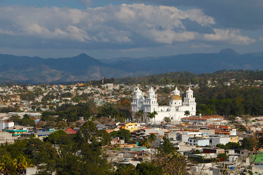
Our first destination was Quetzaltenango (most often called Xela, which is a derivative if its indigenous name), and we planned to hang out there for a couple of days, getting used to being in Guatemala and seeing the local sights. We had been told people boondocked in the Hyper Paiz lot. (Hyper Paiz is a large store chain that has recently been purchased by Wal-Mart; it is big, has many things you’ve been searching for ever since you left the US, and seems reasonably priced.) When we found the Hyper Paiz we were told we could not stay overnight in the lot. Period, no discussion. We were uncomfortable with other options we had learned about, so we decided to try and find a place for the night that would allow us to return for a daytrip on the following day.
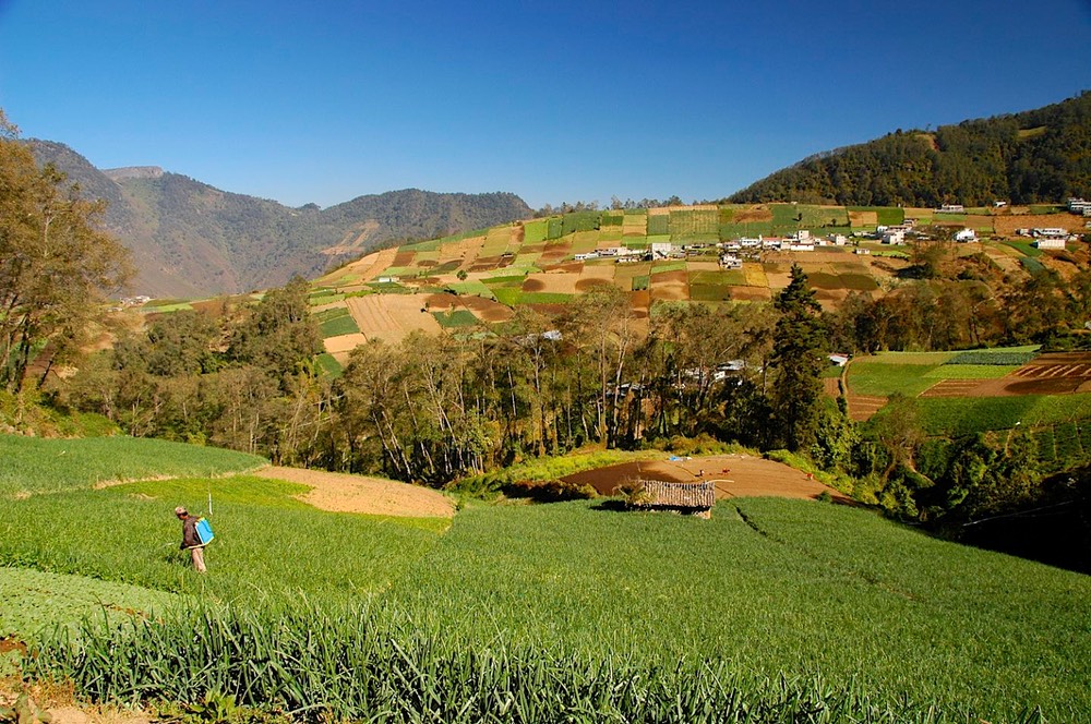
We got seriously lost trying to get out of town, but were rescued by a delightful fellow in a pickup filled with his family, who guided us straight through town and out the other side. And yes, we did have a map, a couple actually; but the road we wanted no longer existed! Having heard very interesting things about Fuentes Georgina, a hot springs resort outside Zunil, which is south of Xela, we decided to head there. This place is quite fascinating. A little hard to find, up a long and winding road that is so narrow the ground cover on both sides makes it a one-lane road; it is indeed worth the bother. This part of Guatemala is famous for its huge vegetables, and they were being grown on both sides of the road we traveled, as well as up the steep slopes we saw in all directions. Although some more modern sprinkling systems were in evidence, much of the land is watered by water scooped out of the ditches that run alongside the fields. The combination of lush green and rich loam hillsides made for a beautiful patchwork. Upon arrival we found that we could, indeed, stay overnight in the parking lot. Our fee would include use of the hot pools. We had been warned that there was a noisy generator that ran all hours of the night, but the watchman showed us an area that was pretty quiet: “muy tranquilo,” he said; and he was right. We soaked, sighing with relief, and crashed for the night, at a cool and breezy 8000 feet of altitude. Heaven!
The next morning we decided, even though we had to go back towards Xela regardless, not to spend more time there; we were interested in moving on, and so headed for Panajachel, on Lago Atitlan, supposedly one of the really delightful spots in this country. But…..they are working on the road between the two towns. And was that a zoo! This is a very long-term project, incidentally; they are rebuilding this road all the way between Xela and Guatemala City. We figure about 10 years. So, what’s roadwork like, Guatemala-style?
First, you take down all the road signs. Now; not when you are ready to work on an area; now. (This was one reason we got so lost in and around Xela.) Traffic is stopped for long periods; well, at least some of the traffic. There’s a big board across the road, with big nails in it; that board gets moved aside for the work trucks…..and, we think, for an occasional person with “special” needs. Then, when it’s time for all of us to start up, the chicken busses zoom out in front first. They crowd everyone else aside, and quickly move out; they race ahead…..until the first hill. Then we all have to pass them. Then they pass us on the downhill. You get the picture. In our case, we were also foiled by a fellow who casually leaned on the side of our vehicle, and we being polite folks, waited for him to move a bit before we pulled out to get started. We realized afterwards that he was holding us back so that a truck he was “helping” could get ahead of us. Dirty pool!
At other points along this road, instead of stopping traffic, they just had us all drive among the big dump trucks and earth movers and what-all, in huge clouds of dust since this is the dry season; sometimes they were in the middle and traffic was moving on both sides of them, sometimes they were on one or both sides and we travelers were in the middle. It was a free-for-all. Somewhere in the midst of all this we went over the highest point on the Pan American Highway (in Guatemala), at 9920 feet.
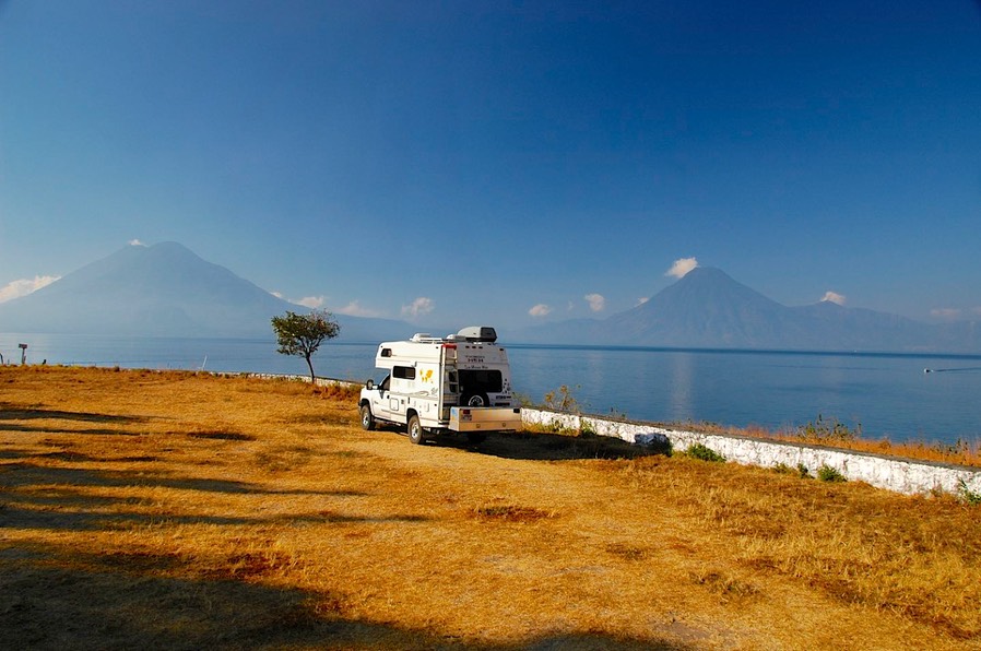
We finally did get to Panajachel – and collapsed. We found a lovely spot at the Hotel Tzanjuyu, in an open field right along the lake. The hotel provides us with hot showers, water, and a dump; and with some electricity if needed at the end of a long cord (we plugged the crock pot in one day). We can get wi-fi whenever the assistant manager has his office open; we try not to abuse this privilege, but he’s most gracious. He and his family live there; he also has a hang glider-paraglider operation that he runs; the benefit of this is the opportunity to see various folks landing in “your” field right at your doorstep. We walk to town every day; it’s a nice town, cleaner than what we have been accustomed to in Mexico. We have found good food (the Maktub’ar Café has splendid wood-fired pizza), good coffee and not two but three English bookstores. We have chatted with a French couple traveling with their 3 children; we are going in the same direction, but they are ahead of us, as they wish to be back in France by Christmas. This is a two-year journey for them.
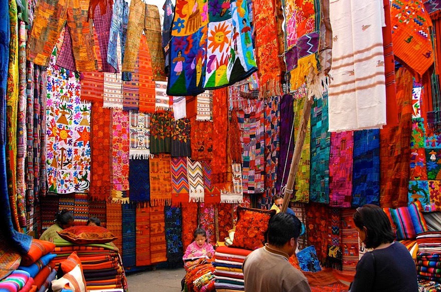
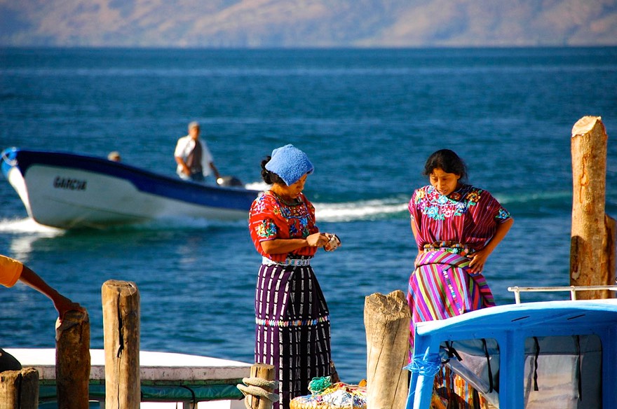
No visit to Panajachel is complete without a trip to Chichicastenango, famous for its twice-weekly street market, almost the biggest in Guatemala. We had a ball. We bought straps for the cameras and a bag for our water bottle; oh, and new shirts for both of us. We even did our best to bargain intelligently. Among other items for sale were baskets of baby chicks, both turkey and chicken; cheep, cheep, cheep! We want out! The day was exhausting, but pretty darn cool.
Another must is a boat trip on the lake to visit villages along the shore. We made do with just a morning’s ride over to San Pedro La Laguna – for breakfast. We’d heard of a great spot; unfortunately it was either closed or had disappeared. But another recommendation took us along a little dirt path that went around the side of a hill, past several meditation and language school opportunities (oh, and Tai Chi), following little hand-painted signs, until we reached the La Puerta Café, where we had a delightful al fresco breakfast while chatting with a crazy lady from Idaho.
About a week into our 10-day visit in Pana (as the locals say) we were joined by Los Alemanias and their rolling hotel bus. Have you ever seen one of these? They are enormous, with daytime seating in front and sleeping berths in the back, little cubicles that remind you of Tokyo. Quite a presence, the bus is about 40’ long with rows of small windows covering the back half. Bright red, you cannot miss it. We had seen them before, but never up close. Two dozen Germans all crammed together for a 3-week trip to somewhere. My!
One piece of business we were trying to take care of: absentee ballots for the coming primary and general elections. We are residents of South Dakota, a state that makes this paperwork relatively easy, but it’s still a chore. We had mailed in the request for ballots, but now have found out we could fax them. So we tried to do that while in Panajachel, but only some parts of some papers came through. Finally, the registrar, in an email, said she had enough to work with, and could send our ballots out (wonderful, wonderful lady). Later, she even said she’d actually received our paperwork; took about two and a half weeks. So that’s done! Our primary is in June, but you have to start early for these things.
Well, a person could stay in Panajachel for the winter; lots of folks do, or even move here permanently. But not us. We took the back road out, heading for Antigua. The back road is long and tiny, but it keeps you off that highway full of construction. Part way along, you can choose to join that highway, or else swing around to the south, approaching Antigua by way of Esquintla. We chose Esquintla; this route gave us the chance to get to a lower elevation and see some different countryside.
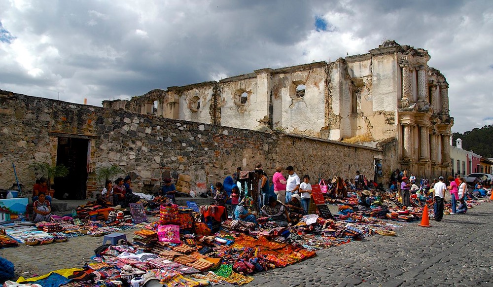
Antigua is the old capital of Guatemala; it was pretty much demolished in a series of earthquakes in the 1700s; finally the powers that be said to hell with it and moved the capital to a new location, creating Guatemala City. So Antigua (actually Antigua Guatemala) mostly is newer than “Colonial,” except for what’s in ruins. It’s a mixture of cleaned up rubble and buildings that date to the early 1900s perhaps. It’s a great combination. But it’s a tough place to find somewhere to camp. We had reports of various hotels as options, and the most common reference was of a parking area out beyond the bus terminal. We checked the latter out first, but found it locked and unattended. Rather than chasing around an old, old city trying to find hotels in unknown locations, we decided to make our way to the center of town and throw ourselves on the mercy of the tourist office. Getting downtown was interesting; some of the streets have bollards to keep out the big trucks (we squeaked through), but in general the streets are wider than in colonial Mexican towns, and we wiggled along.
Visiting the tourist office was a good idea. The fellow spoke excellent English, knew what we needed, and got us settled. He directed us to the enclosed compound where the tourist police kept their vehicles and had their headquarters. It was an open field with plenty of room, cost us nothing, and we were only about 3 blocks from the center of town. No services, but I suspect they would have been happy to find us a bathroom if it were needed. We stayed two nights, and they wouldn’t have minded if we’d been there longer. The chicken busses were noisy until around 7-8 at night, but after that it quieted right down. We were delighted.
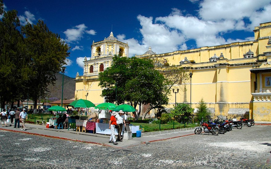
We had a great time in Antigua, walking our feet off and eating ourselves silly. We could have stayed much longer, but the pull of the unknown continues to tug at us; we are very anxious to get further north into the mountains, and then up to Tikal, the great Guatemalan ruins to the far north. So we keep moving.
We’ve hit one snag that has to be attended to soon. We are beginning to run low on propane. Information sources had indicated that propane is plentiful in Guatemala. This may well be true if your rig uses portable fuel containers. We don’t, and are finding it difficult to track down a location that can service us. We missed an opportunity (probably) in Esquintla, and have decided to backtrack toward Quetzeltenango (Xela) where we feel pretty certain we can get what we need. (We stopped in Chimaltenango along the way; we finally found their Zetagas (propane) place, but they only could fill portable tanks; our tank is built into the truck.
So we keep on going, heading across the Planos de Patzicia, with enormous truck gardens that sport huge signs saying the seeds are being provided by a company in Idaho. Back into the mountains on a lovely little road, through squeaky Patzun (we think we took the wrong road through town – what else is new?). We stopped for the night in Panajachel, then endured the same construction zone as before, and on to Xela. And, after a bit of an adventure, we found the Zetagas folks. And, no they couldn’t actually help us. But wait! The guy made a couple of phone calls, then hopped in his car and told us to follow him. Yikes! Back into Xela again! Oh, no! But it was great. We trekked along after him as he squiggled his way through traffic into the city. He stopped, made one more call, then waved us along after him. Suddenly, on a side street, he pulled up and indicated we had arrived. But where were we? Who knew? All of a sudden, a big truck pulled up, the guys hopped out, unhooked their hose, and proceeded to fill our tank. He’d made arrangements to have the mobile truck meet us and take care of us. Now that’s what I call helpful! Ten minutes later we were on the road, with smiles (and tips) for everyone. Right around the corner was a brand new Wendy’s, where we had lunch (AND free wi-fi), and across the street a Paiz where we could do our shopping. An all-time perfect deal. We were SO pleased.
Okay, chores are done. Off to Huehuetenango, where we spent the night. We had heard about a couple of spots, but couldn’t find them; we ended up having a very quiet night at the Pinos Montana Hotel, right on the outskirts of town. They put us into the interior courtyard area, and security kept a close eye on us.
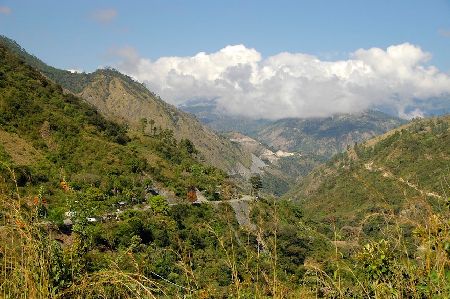
Next adventure: we wanted to take the road from Huehuetenango to Coban. All reports said it was a stunningly lovely trip through “the real Guatemala” -- but also that there was a section of ghastly, unpaved, in-the-middle-of-construction road that was AWFUL. Well, right on all counts!
We took it in stages. The first part of the road is really great. We took a detour partway along, going up into the Ixil Triangle to visit Nebaj, Chajul and San Juan Cotzal. The road goes up and down through the mountains, at one point climbing 3800 feet in 8 miles. Rick figures this works out to roughly a 10% grade, but of course it isn’t a straight shot, plenty of ups and downs, so some of the up grades were considerably greater than 10%, quite astonishing. These small, tucked away villages are only now catching up with civilization, have a proud heritage of independence and adherence to the old ways, and are very interesting to visit. They tolerated us well, but are not really set up for tourists, so we merely passed through, enjoying the lovely mountainous countryside and a chance to see “old” areas.
Rejoining the main road, we spent the night in Uspantan. We had heard from one source that they had spent the night on the town square, and it had been pretty noisy; we were hoping to do better. We found what was supposed to be the tourist office, but it was closed. Inquiring next door, this very nice fellow led us through town to the home of the woman who was volunteering to “do” tourist duty. After a lot of phone calls and sending her sons off to check on possibilities, she found us a place for the night: in the (secure) parking area of a small hotel, which was also -– a mechanic’s repair yard. It was quiet and sufficient, but hardly a highlight of our time in Guatemala. The next day – on to “the road from hell.”
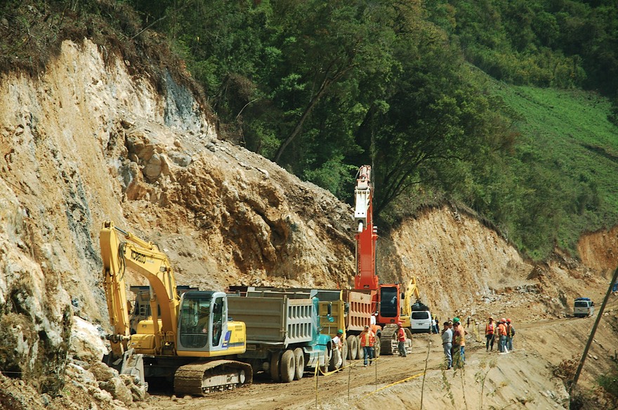
Guatemala’s new roads are created to a higher standard than Mexico’s – they are a real pleasure. And our road (7W) was complete all the way (going east) to Chicaman. Then it is unpaved until you get to San Cristobal Verapaz. That’s 51 kilometers of unbelievably difficult road. We had been warned about this section, but had imagined that it was an existing two lane that was being repaved…NOT! This was a case of an always unpaved track being turned into a modern two lane highway – very, very slowly. It was narrow, it was (profoundly) muddy, it was very much up and down and around, it was chock a block full with trucks and shuttle buses, it was (of course) supremely disorganized; in short, it was every vehicle for itself and watch out for the big rigs. In the end, we survived without damage but were awfully glad to have the four wheel drive, ‘though few of the other vehicles had that luxury. In retrospect it was an adventure, as advertised, but there were times when it was a bit tense.
Finally back to paved road, we made the rest of the trip up into the mountains and Coban without trouble. We settled into Parque Nacional Las Victorias, very close to the center of town. They have a nice grassy area under the trees where we can camp, with water nearby. We can shop, wander town, and --- more business to take care of – try and make arrangements to have our mail forwarded to us. We figure this needs about 3 weeks lead-time, and are trying to call places further ahead on our route to see if we can receive mail there. Just another part of the adventure! Coban is small enough to be very enjoyable, but big enough for a shopping mall that is right on the main drag into town. Heaven, some would say! One special attraction we enjoyed was the Vivero Verapaz orchid nursery, which is just outside town. Although we were too late in the winter to see it at its best, this is a lovely spot and there were plenty of flowers to enjoy. We had a delightful visit.
And then…..we decided to change our plans, and make an abrupt right turn. It’s the old getting-the-mail-forwarded dilemma. As we have figured we need about 3 weeks lead-time, and we need the mail to include some medications, it’s complicated. The spot we were hoping to use, a brewery we wanted to visit in Honduras, wasn’t answering their phone or returning our e-mailed questions. So that was out. What to do? We finally decided on, and made excellent contact with, a finca in eastern Guatemala that would be happy to receive and hold our mail. But we weren’t expecting to continue to be in Guatemala for that much longer. So… hey, let’s go to El Salvador while we wait for our mail! It’s small, it will take about the right amount of time, and we want to go there anyway.
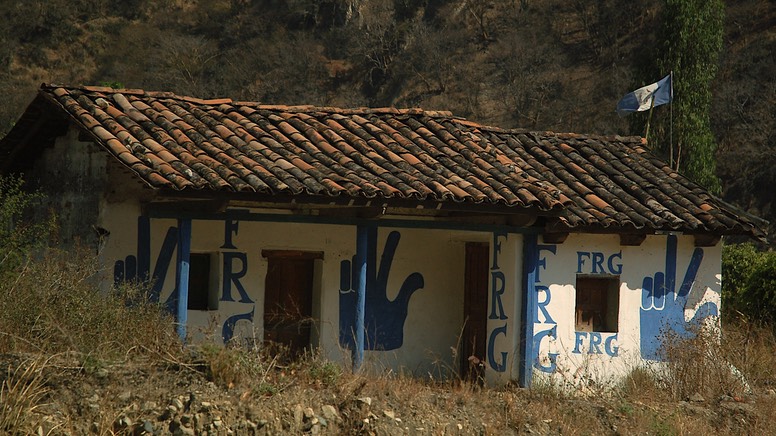
(But wait a minute, you say? What about the Frogs? What frogs? Oh… those frogs! Well, here’s the deal. Throughout Latin America, politics is a visceral thing. People express themselves openly. They broadcast through loudspeakers. They paint signs on walls… and rocks… and telephone poles and anything else they can find. There is one party here in Guatemala whose initials are FRG; their colors are blue and white; and their symbol is an open hand with the fourth and fifth fingers tucked down into the palm. So common… it’s a sort of like a peace symbol, right! And FRG very quickly becomes FROG in this beady little brain. So… FROGS FOR PEACE.
We had decided to visit El Salvador from Guatemala and then returning to Guatemala afterwards. This was a strategy to avoid famously difficult border crossings between El Salvador and either Nicaragua or Honduras.
So we headed off toward El Salvador (or El Sal-ba-DOR as they say) from Coban. We got about 50 miles and stopped for a hopeful search for Quetzals, the beautiful bird that is the national symbol of Guatemala. Our road took us through a lovely cloud forest and quetzal sanctuary corridor. Guatemala is working hard to develop this area as an eco-tourism destination. The corridor stretches for many miles, and has several stopping places, either at land owned by the government, or by private parties adjacent.
We stopped at two different sanctuaries. After hiking up and down and up and down through the first one (where we had stayed the previous night), we were treated to tea/biscuits/fruit by the lady of the house. She was absolutely charming, and thoroughly made up for our disappointment at not seeing a quetzal. We moved 50 yards down the hill to a public sanctuary, and trekked through their part of the forest keeping our eyes peeled, but we weren’t that lucky; we did see other birds, and some lovely flowers, however. Oh yeah, and an interesting young lady on a Saturday outing who walked the whole trail in high heels that matched her metallic burgundy two-piece strapless outfit with very tight pants - we were in hiking boots. (Rick said, “she was wearing heels???)
We spent the night at the sanctuary, in their parking lot. We were all alone except for the security guys, who were very interested in our rig and what we were up to. We spent a lot of time talking with them, and made some new friends, particularly a man named Esias, who even let me take his picture. It’s these connections that we treasure.
Tell me: what’s the difference between a cloud forest, a rain forest, and a jungle? We are clueless. And wet. We’ve decided that these areas have their own weather rules. But… you only get wet once. And yes, jungles do have bigger bugs.
Despite the lack of quetzals we had a good time at the sanctuary. Early the next morning we waved goodby to Esias and his buddies and made for the border. For the first time in quite awhile we were on good road, and Rick found himself doing all of 45 mph; he got quite excited.
Down, down through the cloud forest; we dropped out of the highlands and found ourselves in an area that looked like the Baja: dry, dark brown, with few trees. We were between mountain ranges, and down to 650 feet; pretty darn dull we decided. Later in the day we climbed up again, over 3800 feet, ending at about 2000 feet in Esquipulas, with a very famous (but boring) basilica. The town was an absolute madhouse, as it was Sunday and the faithful were lined up for blocks going into the basilica to see its version of a “black rice” (Black Christ) statue. On Monday all had quieted down, we were able to enjoy the town for a couple of hours, then arrive at the El Salvador border in good order. We crossed on February 18th. You can read about our El Salvador experiences in A Pleasant Experience.
After 8 days in that country, we returned to Guatemala through the same border town where we had exited, and drove back up to Coban, very much appreciating the increasing beauty of the country as we approached the quetzal sanctuary corridor/cloud forest again. We returned to our same campground in Coban, and, amazingly we were shortly joined by a sturdy rig with Arizona license plates! We spent a couple of days sharing experiences with Don and Kim, who are amazing trekkers; they’ve been in many countries and had lots of information for us. They had recently shipped into Panama from Australia, and were on their way back to the United States for a bit.
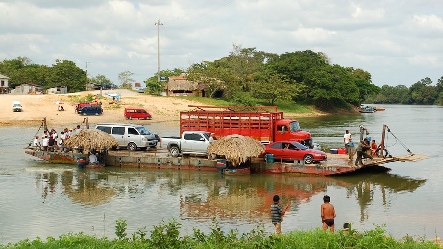
Parting company, we resumed our Guatemala adventuring. While our mail began its journey to catch up with us, we turned our faces to the north into the Peten (what northern Guatemala is called) and the ruins at Tikal. Our journey toward the top of Guatemala took us back into areas of more traditional dress, at least somewhat. We’ve found that once you leave the western highland area, you are much more likely to see people wearing clothes just like in southern California. The guidebook says “European,” we say “just like us.” But aside from clothing, the sights were as expected: lush fields with corn and cows at lower elevations, coffee at certain levels, even some papaya plantations. We crossed a large river (the Rio la Pasion) on a barge. Well, it was a ferry, but sure looked like a barge to us; very reminiscent of the Northwest Territories, oh yeah, and a great little ferry crossing the Mississippi on a back road near Baton Rouge, Louisiana. The whole scene was so evocative of rural latin America; guys washing vans in the river, kids swimming, lots of vendors selling treats to those in line for the ferry, and summarizing the entire make do attitude you find down here, the ferry is propelled and steered by a couple of outboard motors. Great scene.
Further north, we entered Flores late in the afternoon. Flores is the jumping off place for day tripping to Tikal. It’s a nice little town on an island in the middle of Lago Peten Itza. We wandered the quiet streets, enjoying the water, a nice meal, good internet, and the constant buzz of tuk-tuks going past. Shortly before arrival, I (Kathy) was wandering in the back while we were on the road, and said “Oh, oh, Rick, I think you need to stop. I think we have a broken window.” One of the two front windows on the overhead cab had caught a rock and was shattered. Well, many phone calls and decisions later (thanks to good internet), we had a new window on the way to us from South Carolina, being sent to the same place as our mail. More excitement (and cost) than we anticipated on the day.
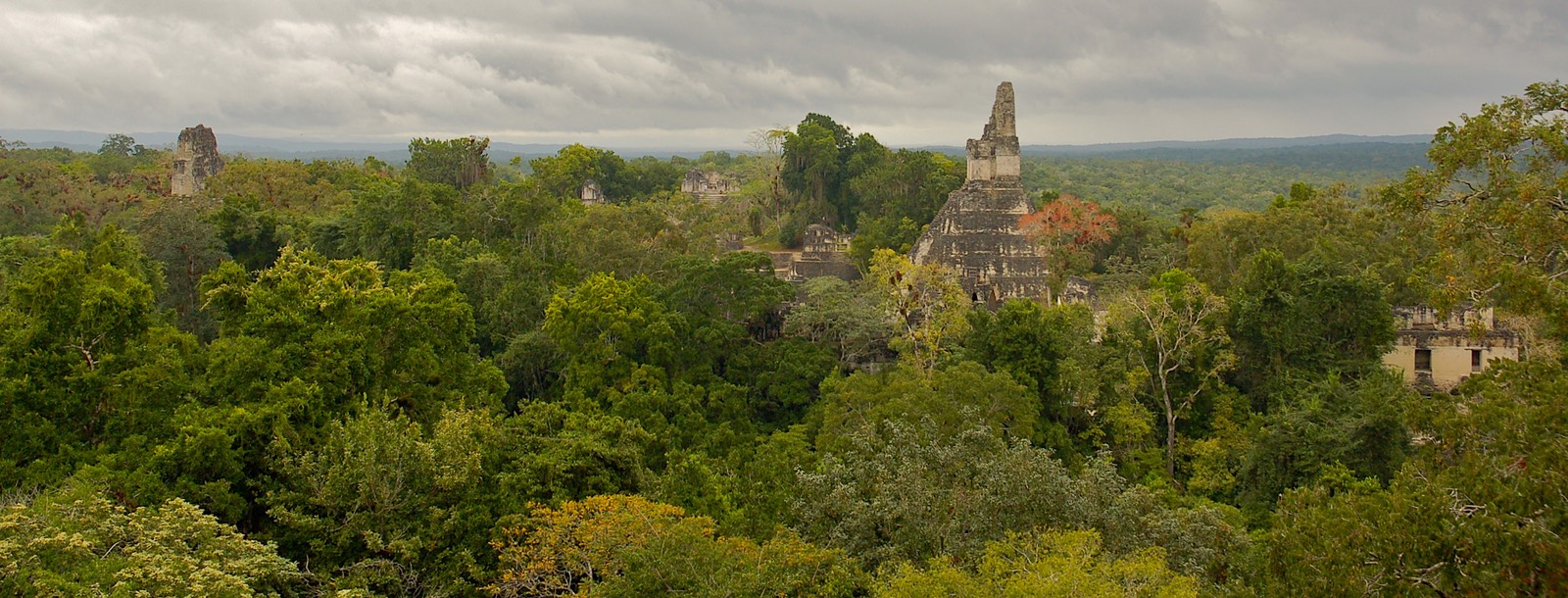
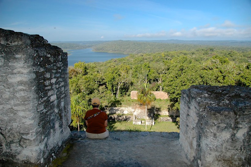
But on to Tikal. The ruins here are the most famous in Guatemala, and rightfully so. They are magnificent, and in a wonderful jungle setting. It was quite rainy the afternoon we arrived. We had been told (correctly) that if you got your tickets after 3:00 pm, they would be stamped for the following day, and you could enter both today and tomorrow. But it was so rainy we decided to wait until the following morning in hopes of clearing weather. We camped in a pretty field with lots of trees, right by the entrance. In the morning it was still raining, but we decided to go on in. As we approached the ticket booth, we met a couple of fellows who had been there for the dawn patrol (there is a trek to the top of Temple IV at daybreak to see the sunrise). It had rained the whole time, they were drenched and unhappy, and would be delighted to sell us their tickets at a discount. Everybody was pleased with the transaction that followed.
We entered the park and were enchanted. It is a lovely place. If you stayed under the canopy you didn’t get toooooooo wet, and it wasn’t toooooo hot. We climbed the pyramids, took tons of pictures, heard/saw birds and monkeys, and then, about 10:00 the sun came out. We were on top of Temple IV at the time. It was cool. Temple IV goes up high over the canopy and you get quite a view of other tall structures. A neat experience. My camera had gotten a bit wet, but dried out in the sunshine. Apparently Temple IV is the “biggie”; it was a weekend and lots of locals were in the park, most of them headed to the top of Temple IV. Bizarrely, when they would finish the climb to the top, they would get on their cell phones and call all their friends.
We had a great time at Tikal; we recommend the experience highly. There are several nice hotels to stay at in the park, the area to be walked isn’t insurmountable, and it was fun. We camped for a second night, and then went back to Flores the following morning (about 60 kms). We had a solid recommendation for a place to get propane, so we topped up the tank. After accomplishing that chore, we had another ruin in mind: Yaxja.
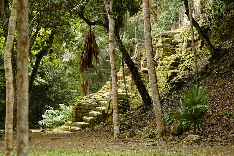
The Yaxja ruins are off the road that runs (generally) between Flores and the Belize border, to the east. You will have heard of them if you followed the doings on Survivor: Guatemala (we hadn’t, but the show was filmed here). At Yaxja we found the best setting for ruins that we have seen yet. We were tremendously pleased.
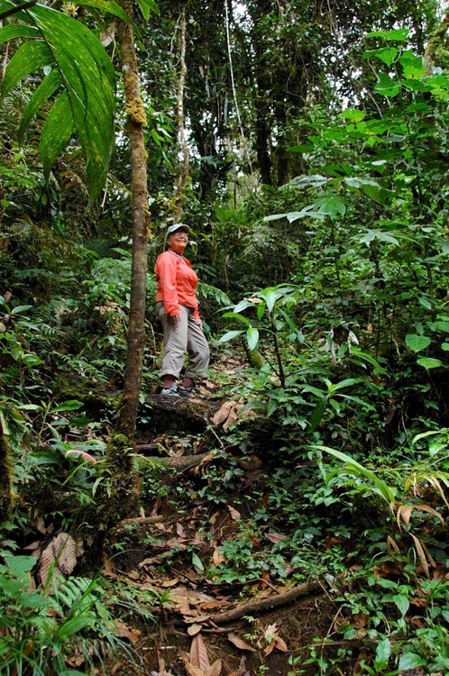
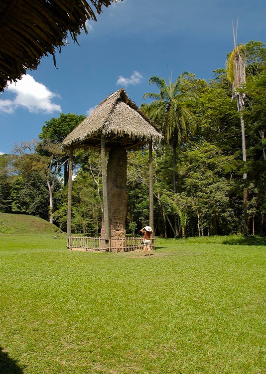
Yaxja is a relatively new site, with major restoration work having been completed just in mid 2007. It has not yet been discovered by the big tour groups, so it is very quiet and undisturbed. Set in the jungle near a lagoon, it’s a quiet paradise. The howler monkeys were fascinating, we saw several different kinds of birds, and the ruins themselves are quite amazing. We had a lovely day’s wander, climbed everything in sight, and spent two nights beside the lagoon, all to ourselves. The guides were very helpful, and they liked the fact that we were camping with them.
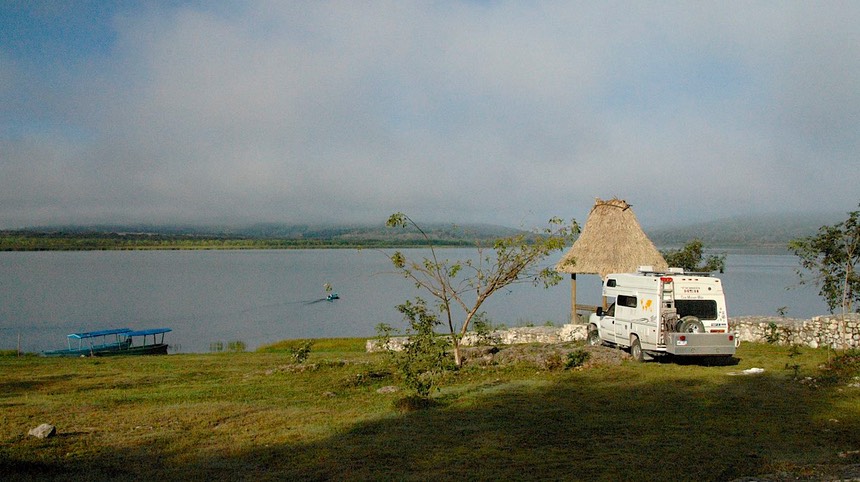
We were tempted to set up a permanent campsite at the Yaxja Lagoon, because it was so quiet and beautiful, as you can see in the photo.
We were quite close (100 kms) to Finca Ixobel, our next planned stopping place so we finally decided to press on. This is where our packages would be arriving (soon, we hoped); we’d be able to take hot showers, eat good food, and generally relax and recuperate. All this was what we’d been told by others.
And they weren’t wrong. Finca Ixobel is an oasis rising out of the jungle. It has some elevation (about 1700 feet) and is in a pine forest. There is cool shade, a swimming hole, an excellent restaurant that makes its own bread, electricity to help the refrigerator in its efforts to cope with all those days in muggy 90 degree heat, etc. etc. etc.
Finca Ixobel isn’t far from the town of Poptun, and we’ve wandered in there a couple of times. The first time Kathy caught a ride and did some shopping. Catching a tuk-tuk back to the finca was a real adventure by itself. Shortly after hailing my ride, my driver (gorgeous and about 40), stopped for a minute, stepped into a store front, and came back with two mango fruit bars, one for me. What a delightful fellow! The next day, we drove the truck into town to take care of some things. My tuk-tuk guy saw us several times as he made his rounds through town, waving and honking each time we came into his view. It was great fun.
One reason we’d taken the truck into town was to find a welder…seems to be kind of a recurring theme here. If we ever write a book, it’s going to be titled Welders Round the World. On this occasion, we had noticed, the same day the rock hit the window, that our rear spare tire was suddenly wobbling around; the welding we had had done up in Whitehorse last summer had failed. Fortunately, the aluminum boxes once again had proven their value by keeping the spare from bouncing off down the road somewhere we would never have found it. So, we had the whole thing remounted and reinforced for probably about one tenth of what it would have cost in Whitehorse.
As so often happens in these situations, our encounter with the welder and his family provided us with a nice experience and a great story to share. In order to do the repair we had to first remove the storage boxes, and to do this we needed to empty them out to make them lighter. Well along with the tools and hoses and other items, there were two cans of Campbell’s Chunky Soup and a big jar of Jiff Peanut Butter being stored back there. Well, the welder commented on this while we were unloading, and then later on an older woman, presumably his mother, came out and showed great interest in a can of the soup, so Rick graciously gave it to her and she scurried back into the house with her new treasure. Well, the uproar of excitement that ensued convinced him that the second can needed to follow the first; but he made a show of hanging on to the peanut butter, and laughs were shared all around. Along with the welder calling to a passer-by to come help remove the boxes, and Onises, the welder’s son helping to reload everything into the boxes, a needed repair job evolved into a cultural exchange of the sort we enjoy so much.
We stayed at Finca Ixobel about a week, our packages arrived (the mail, via the postal service in thirteen days; the window, via UPS – at exorbitant cost – in five days) and then we prepared to head for the Honduras border. We had one more ruin to visit in Guatemala, at Quirigua, then we'd go on to the border, and the Copan Ruinas, right on the other side. In Guatemala it’s Coban; in Honduras it’s Copan; we haven’t a clue as to why. One thing we forgot to tell you was that we wanted to buy coffee from Finca Ixobel. They are well known for their coffee and were happy to put together a bag for us; when she was ready to seal the plastic, she used the flame from a candle she had lit for just that purpose. It was an old-fashioned candlestick just like out of Dickens. It was a special moment.
We made a stop at Rio Dulce, a very famous watering hole right along – guess what! – the Rio Dulce. This large river flows out of Lake Ixobel and into the Caribbean. It’s a favorite spot for boaters; they pull in for fun and supplies, or protection when the weather is unfriendly further out to sea. It’s a lively place, and the cool spot to camp is at Bruno’s. Bruno’s advertises its location as “under the bridge” and that’s pretty much just about right. “The Bridge” is the longest such item in Central America. It crosses over “The River” and lets the traveler go further south along Guatemala’s eastern border. Tons of truck traffic, so it’s not a quiet place, but still a pleasant if slightly weird experience.
We liked being there. Rio Dulce is international in flavor, so we were able to do some interesting grocery shopping; the boating crowd tends to have American-type food needs, so that was great! I’d been looking for Italian seasoning for weeks, with no success, and finally had arranged to have some shipped to me: but there it was on the shelf of the first grocery I walked into! Damn! And Rick was able to locate a new bomba – a pump to boost the low water pressure we so often have to deal with. We filter all of the water we put into the fresh water tank on the coach, and often the local water pressure is too low to get the water through the filter; hence the need for a booster pump. We’d gotten one at a Home Depot back in Mexico, but it wasn’t very satisfactory.
We had showers, a nice chat with the manager of Bruno’s, an expatriate who’s been in Guatemala for about 15 years, and gave us lots of good information, even walking Rick through town to get La Bomba and assorted hardware. He is very active in the local area, involved with building a school, teaching English classes, etc. Very busy, and never a dull moment.
Moving south, we were getting into lush countryside, with banana plantations everywhere. Along the road we were following we encountered bits and pieces of a traveling circus, heading north up into the Peten. We were reminded that Semana Santa was fast approaching. We made a great stop to visit the ruins at Quirigua, on the edge of a banana plantation. The ruins there are quite special. They are famous for very large, intricately carved stelae. The setting is tropical and lush, and these monoliths rise up out of the grass; they are protected with thatch-roofed structures, which seem to add to the scene. We were very impressed. Stelae carved in a similar fashion are in evidence at Copan, right across the border into Honduras, a much more famous site. But we found Quirigua pretty darn special, and the setting much more interesting than at Copan Ruinas, which is much drier and filled with tourists. (More on that later.)
So Quirigua was cool. But we were heading for Honduras. After a quick stop in Chiquimula for some shopping (and one last ice cream at Pollo Comparo – which quickly melted in the deadly heat), we were border-bound. We crossed at El Florido (not to be confused with El Florida – what is this?????) and found ourselves in a New Country. Again, an easy crossing. Rick is beginning to think he’s magic! He admits that dread of all the border crossings was the main thing making him think twice about this trip of ours, but so far, so good.
So, Semana Santa you say; what’s that? Well, officially, it’s Holy Week. But practically speaking, it’s more like Spring Break in the United States, only bigger; lot’s bigger. All of Mexico and Central America (and, we are told, South America as well) takes the week off. We travelers try and find someplace to hide. Literally. We try and choose a place to get to that’s not popular with the holiday crowds. And hunker down until it’s all over.
Our time in Guatemala has been enjoyable and instructive. We’ve been here about five weeks and could easily have stayed longer. We’ve been impressed by the beauty of the mountains, forests, and jungles we’ve seen. Lake Atitlan is truly an extraordinary area, as promised. The high mountain roads and old villages; the large numbers of indigenous people, both women and men, wearing traditional dress and the variety of that dress from one region to another; the neat and prosperous looking fields of fruits and vegetables with irrigation systems and signs of constant attention from the workers; all these things and more have impressed us. As mentioned earlier, the roads are built and maintained to higher standards than in Mexico, and are generally far cleaner as well.
Indeed, we saw numerous crews along the roads not only picking up trash, but patching potholes and painting the concrete drainage channels installed along the roads – we’ve never seen a clean up crew in Mexico. The people we have met have been unfailingly friendly and helpful and have added immeasurably to our enjoyment. And, there’s Pollo Comparo, a frequent sight along the road anywhere near even a medium sized town. The Colonel done in a south of the border style; clean, modern and obviously very popular… and with hands down the best fast food ice cream cones anywhere! Fast food is pretty darn big down here, with McDonald’s being the most common after PC, and they really do it right. They generally have large staffs of neat and friendly workers handling large crowds in efficient fashion, and the food tastes… just like home. All in all, as our first stop on our Latin American journey, Guatemala gets very high marks, just a terrific country to travel in.
As you can see, we’re doing fine. The heat in the lowland areas really gets to us (not to mention the refrigerator); but when we’re at higher elevations we are having a ball. Central America is all we could hope for, and more. Come see for yourselves!
Click here to see more pictures of Guatemala.