March-April 2022
Desert Dust
A bit of a wander through Arizona, California and Nevada
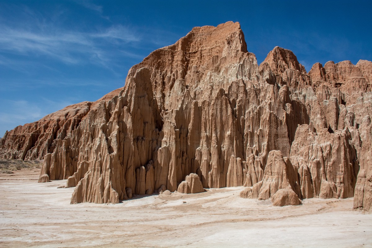
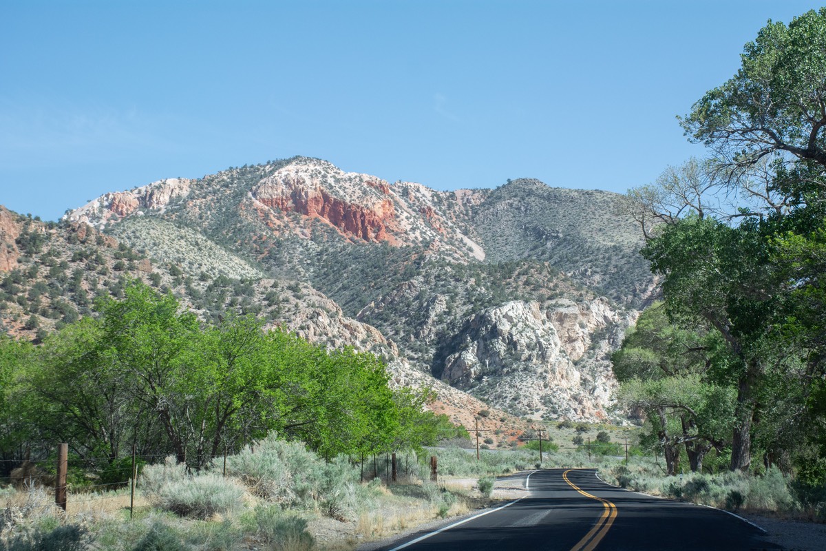
(Note: we don’t have photos for the early part of this story, so we’ve scattered some from later on throughout)
Dear Friends,
It has been a terribly long time since we’ve written; almost two months. Perhaps that’s because we’ve mostly been flitting across the country, visiting with friends and family, and taking care of chores as we’ve gone along. No real adventures to entice you with — well almost none, but we’ll do our best.
To bring you back up to speed, we sent out our last message just after arriving in Arizona, along the way between Alabama and California. We’d taken a few days off from just making progress, and run down almost to the Mexican border to spend three lovely days at Organ Pipe Cactus National Monument, one of our favorite spots in the whole wide world. Rained the middle day, but who cares.
Back on duty, we kept moving further north and west. After a quick stop to visit a great-grandson (and the rest of the family, of course!) in the Phoenix area, we took the time to go south of Quartzite to explore the very nice Kofa Wildlife Refuge. By now we were really in the middle of the southwestern desert and were drifting from one refuge or open camping area to another, enjoying the solitude and quiet of each of them. And yes, of course, a certain amount of the aforementioned wind and dust. From Kofa we moved across the border into California, briefly dropped down to Lake Havasu for an overnighter with a friend there, then out into the Mojave desert.
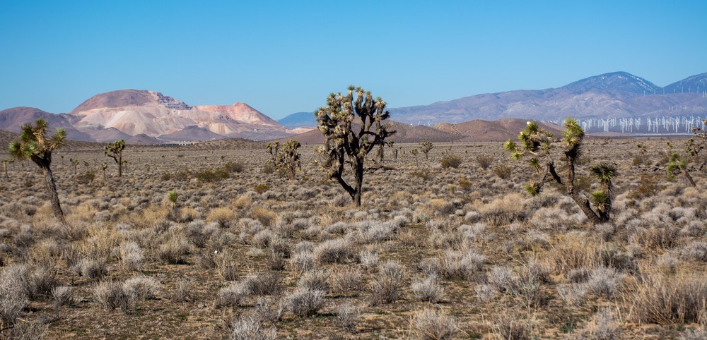
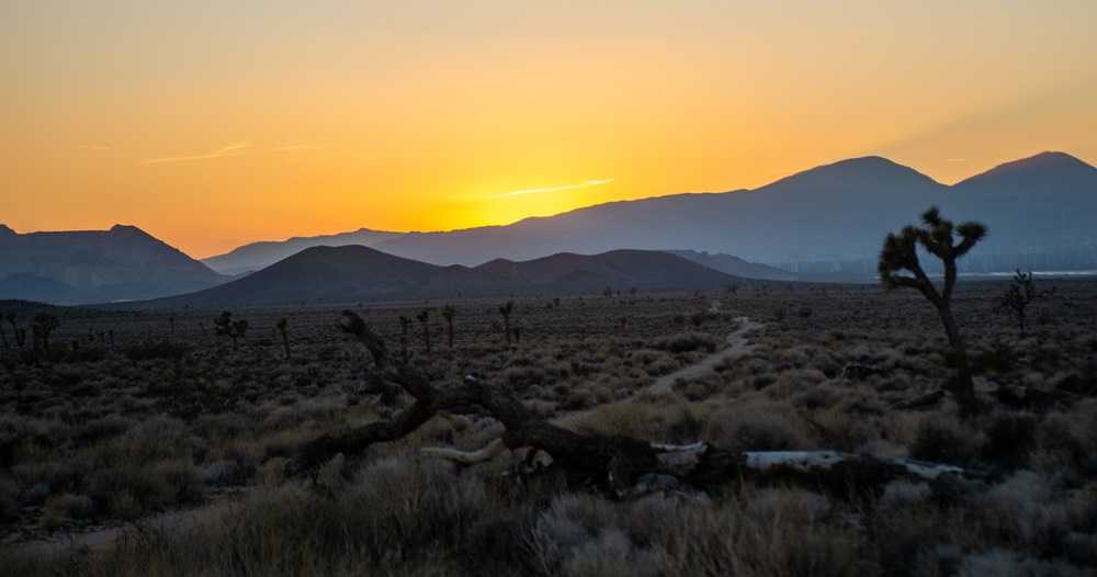
Oh, no, you say! Not the Mojave; nobody stays in the Mojave desert. Yucko!! Well now, wait a minute. Yes, that’s what we’d always believed. But! And that’s a really big (hmm) but! There are indeed interesting spots, and we hunkered down for a few days out there in the middle of it all — and enjoyed it. We’d found a spot that was full of great big Joshua trees and yucca plants, with mountains in the distance to the south, and further west from us a very large hillside covered in wind turbines.
Now, we happen to be strongly in favor of wind farms, and were pleased to have them nearby. But something we hadn’t known was that at night they are covered with red lights that blink on and off as a warning to air traffic. They were really cool to watch — like Christmas in March. If you’ve not experienced a wind farm at night, you need to go find one. It’s a treat!
Having arrived in California, we were heading for the San Luis Obispo area, from whence we come those many years ago. We traveled on Hwy 58 from Barstow through Mojave and over Tehachapi Pass , then hooked up with Hwy 166 toward Santa Maria and on into SLO. Delightfully, once we went over the pass, we encountered fields of lupine and poppies, yellow mustard and other wildflowers. Such a difference from the deserts we’d been wandering through for the last few weeks.
In Tehachapi diesel was $6.44/gallon. Yeah, well, you all know that fuel prices have jumped over the past couple of months. Great time for a cross country trip, huh?. And, everyone knows that California has the highest prices in the country, so this was kind of a “Welcome to California” sign. Overall we spent about three weeks in CA and, through daily use of Gas Buddy, we were usually able to find prices on the lower end of the scale. We passed signs showing diesel at between $4.99 and $6.99, but were mostly able to get it more or less in the middle; around $6 a gallon, roughly a dollar more than in neighboring states at the time.
Hitting San Luis Obispo, we enjoyed 3 weeks of meet and greet, plus the usual visits to a couple of our favorite medicos. Almost overwhelming, but we enjoyed every bit of it. When we were finally leaving the area, we had just acquired 2 dozen fresh eggs (gathered just before we left our friend’s farm where we’d stayed the night) for me to share with compadres further north. Farm-fresh eggs are quite special, and thoroughly appreciated; it was part of the fun of visiting.
Wending our way further north, we happened to drive the back road from Napa to Calistoga on Hwy 29. We want to share with you that it is a lovely, green, winding road past Clear Lake and beyond, before cutting over to I-5 and up towards Lake Shasta. It was spring at its best, with lots of wildflowers on a nice bright day. Must tell you that Lake Shasta is quite depressingly low. But we enjoyed being back in the mountains of northern California. Saw the results of some of the nasty fires in the area, east of the lake. If only this year could be better, but not much chance of that.
So, if you know California well, you can see we are in the far northern part, above Lake Shasta. Our next plans were to get into southern Oregon and take care of some truck business, check on the new house being built by friends outside Grants Pass, then drop down into Medford and Klamath Falls, bounce off Susanville and end up in Reno, Nevada. Got all that?
But we also wanted to wander over to Crescent City to see some buddies and then drive a road we’d been wanting to take. So after a nice weekend with our friends, including great fish and chips down on the pier, we set out to explore this new road we’d seen on our trusty AAA map. This road looked really, really cool. It takes off up the coast from C City, actually from Gold Beach, Oregon. It cuts east through the coastal range and then drops down into Grants Pass.
And a lovely drive it was, at least for the first chunk, good pavement followed by gravel, and the Tiger was enjoying stretching his legs for a change. Then we ran into snow, some of it lightly falling on us, but mostly a large bank of it stretched across the entire road, with much more dead ahead. We hemmed and hawed, fussed about what the problems were, and finally, quite disappointed, we backed and filled and turned around, and retraced our path. We had to return almost all the way down to Crescent City before we could get to “the usual road” through the redwoods and back to the civilized world. Our experiment in trip planning cost us about 200 miles that day but we don’t regret it a bit.
Later, we found out the skinny about this road, as spoken by locals on both sides of the pass: “It’s a very difficult road”, “Only the crazies drive it in the summer.”, and “The search and rescue people have to go up there every winter to retrieve people who’ve gone off the edge and ended up a long ways down the side of the mountain.” “Folks die up there every year!” This is the road that goes over Bear Camp Pass — OR 595 & 425. Check it out if you don’t believe us.
As you can see, we’ve been sort of wandering through the west, poking around, checking up on our buddies, enjoying springtime where it’s available. But now we were heading for Reno and some family. Our route would take us through Susanville, including driving along the edge of Eagle Lake on the way. We had stayed there back many years ago; it’s a very pretty area and you can camp along the lake en route. Sadly, there’s not much lake left right now because of the drought, but we found a spot for ourselves; it even looked a little familiar.
We stayed 2 nights; we think it may be a location we used waaaay back in history, when we came through in the Foretravel, probably back in aught five or thereabouts. The whole area is more developed now, and not as “perfect” — many ATV types use these spots, and don’t seem to mind leaving their garbage and driving around over all the shrubs and grass. (Oops, letting our prejudices show just a bit). But it was still pretty.
And then on to Reno, where we spent most of our time doing some shopping and catching up on unfinished business. Topped off with a great dinner with family. Reno continues to grow in extraordinary fashion. Areas south of the airport have now been turned into extensions of the city; “country-side” has moved many miles further south. The corridor between Reno and Carson City is jammed. We still like Reno and will come back, but it’s been a long time since “The Biggest Little City in the West” was born during the gold rush!
We had originally hoped that following our time in Reno we’d be able to do some wandering in northern Nevada and then slowly move further south toward a wedding in Las Vegas at the end of April. Not a chance! The weather has been really cold these last several weeks, mostly below freezing at night, with more than a fair amount of wind. And now the gusts were becoming very strong. So we felt we needed to get south quickly, where the weather looked better.
We had been shown a really nice back road out of town, that would take us up over Geiger Grade through Virginia City (where we had snow flurries and high winds). The pass was at 6789 feet; but Virginia City is a nice little former mining community that has kept its history intact and the whole morning was a nice drive. Anyway, joining Highway 95, our chosen route south, we were hit with more high wind warnings and signs demanding that we leave the highway immediately.
So we traveled south on lesser roads, regularly enveloped in difficult driving conditions. Between the winds and the frequent encounters with dust storms, even pulling off the road once due to lack of vision, we made our way south. At one point we slowly drove past a semi truck and trailer blown off the road and overturned. Not so pleasant. The worst winds were north of Tonopah, if you know the area. Brutal and ferocious, and very tiring.
We ultimately stopped for the night somewhat further south, and even found a spot for ourselves where we were mostly out of the wind, tucked up against a bluff to the west.
The next morning we turned onto the highway to continue our journey and were promptly stopped for about 20 minutes because of road work. Had a nice chat with the woman who was manning the stop sign. We asked how long she’d been doing this and she said “since 97” — can you imagine? She said she had 7 more years until she’d be 55 and could retire with full pension. She looked far older than that from all the sun and wind, but still perky, and we enjoyed talking with her. Incidentally, she said that the man walking along the edge of the road ahead of us was searching for baby desert tortoises; we’d been reading about attempts to try and rescue them at this time of year, so I wasn’t surprised. La Tortuga was pleased to see this well-intentioned activity.
The only other excitement of the day was traveling past the junction of Highways 95 and 373. I spotted the Alien Colony Bar and thought that might be worth exploring, but Rick said I’d have to go alone. Bummer. Maybe another time.
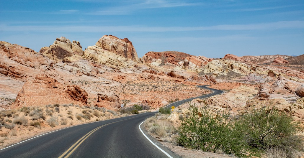
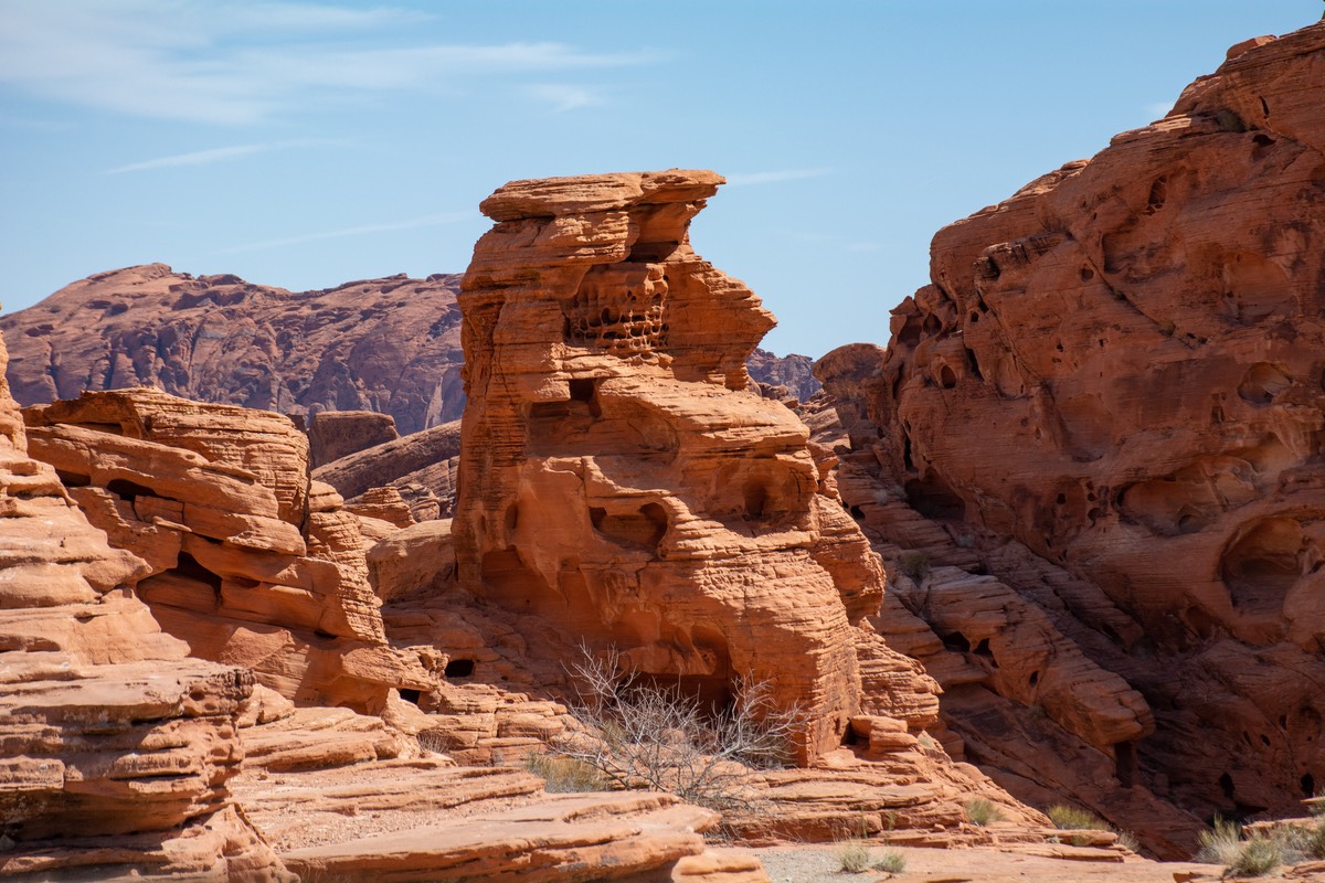
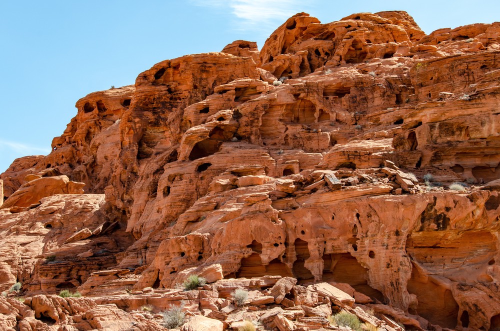
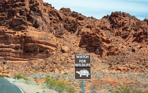
Finally reaching Las Vegas, and knowing that the wedding was still more than two weeks away, we were mostly interested in getting out of the city and exploring some areas we’d not seen before. We began out in the area around Valley of Fire State Park, east of town and full of possible adventures. We found a good spot for ourselves in the dispersed camping area, and settled down for a few days.
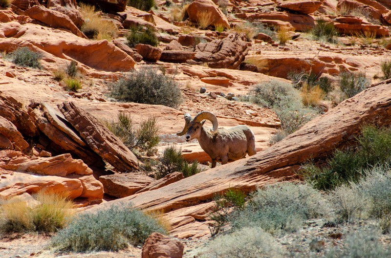
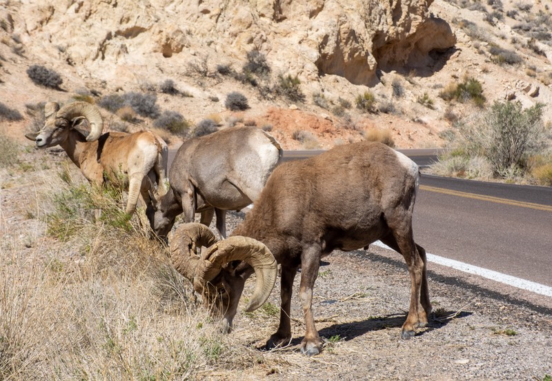
After resting up, we wanted to head toward a spot further north where we were going to meet up with friends to camp with. Getting ready to leave, we still hadn’t been into the state park. So we decided to drive through the park and enjoy its beauty before moving on. We found this to be an incredibly lovely choice. It’s a very popular state park, and there were too many people around for us to really see it at its best, but there is lots to enjoy while driving through, and plenty of hikes to take. Such a lovely place, complete with a herd of Big Horn Sheep; it deserves a longer trip through. You can enter at one end, spend the day, and then, if you want, leave at the other end of the park and continue further north. We had a great time and will come back again when it isn’t Easter Week!
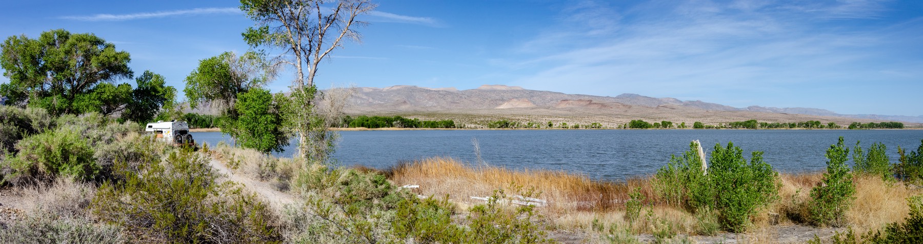
Leaving the Valley of Fire, we took off further north up Highway 93, a lovely drive, on to Pahranagat Wildlife Refuge, right next to a pretty little lake with lots of cottonwood trees. The camping is free, and the place is quite popular. We spent our first night in an overflow area across the road, then early the next morning our friend gave a shout that she was saving a really great site for us, so we grabbed our stuff and scuttled on over. Right on the lake, with super views and lots of breeze, it was pretty darn perfect. We stayed for 5 nights in that spot and would have enjoyed more.
As you can see, we were poking around southeastern Nevada, checking out a part of the world we’d never spent time in before. We decided that when we left Pahranagat we would continue north aways and drop in to investigate Cathedral Gorge SP, further up Highway 93, about 2 miles north of Panaca. We found it less colorful than the Valley of Fire, although there are very interesting, dramatic rock formations; it’s probably best known for its slot canyons. You can’t explore much by car. We decided it was really for hikers, and that’s not us at the moment.
Moving on from Cathedral Gorge, we decided to return further south and head out to Lake Mead for a few days. And, once again, there was a really interesting off-road opportunity that we wanted to enjoy. So! We turned back south on Highway 93 until we reached the nice small town of Caliente, where Road 317 cuts off and plunges further south into a deep and lovely canyon filled with beautiful cottonwoods and following a wash that even had some running water — enough to keep the trees and shrubs green at least. There was a freight train track following the same course, and we ducked under crossing after crossing; none bothered us, but if you were over 14 feet high you might have trouble.
We stopped for the night in a small clearing in the canyon. We saw no other cars the whole day, but had a couple of cows, a couple of (amazingly quiet) trains, and a couple of military jets to keep us company during the night. It was cool and breezy and a real treat.
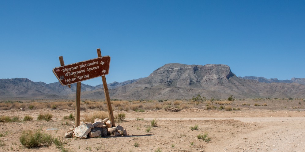
The next morning we continued on; we were following signs leading to the town of Carp. This intrigued us, but somewhat short of that mysteriously named burg our road veered left before it continued further south, following Rainbow Canyon Rd, where we started to leave the canyon and the Mormon Mountain Range it was part of, and eventually found ourselves back on pavement and about to join I-15. Now that was a real change. Talk about culture shock! From isolated canyon to major interstate in about 40 minutes. Whew!
We had had a really cool time of it and were reminded of how much this kind of travel was basic to our happiness. We’ll do that road again!
On the frontage road before reaching the onramp to the highway, we came across a group of Harley riders stopped. One of their bikes was up on the edge of I-15, but the four others had been able to get off the interstate and gather on the frontage road while waiting for the retrieval truck to come. We stopped to see if we could do anything and they really appreciated sharing our supply of cold water. They’d been waiting for two hours. Turns out they were five guys from Montreal who were on the last day of their week’s vacation on rental bikes out of Vegas. The truck arrived just as we were driving off, so they were able to continue on their way home.
The first thing that had happened that morning though, while we were still in our little camp spot in the canyon, was a loud BANG, a large cloud of grey smoke, a squawk, and the furnace coming to a complete halt. So much for any thoughts we had on how the day would proceed! The dead furnace resulted in us shifting our plans and heading directly back into No. Las Vegas to see the heater guy we’d been chatting with about our furnace needing attention. Really; do you think?
After visiting with the heater people for awhile, and having some tweaking done that we will observe for a few days (and yes, it’s been fine ever since), we left Vegas again and headed out into the huge Lake Mead National Recreation Area, east of Henderson. Our plan was to stay here for 4-5 days, then wander back to Las Vegas in time to prepare for the wedding of a granddaughter, who, of course is the reason we were in this area at all. We parked at the top of a hillside, looking down at the lake (very, very low and in danger of reaching disaster status) and very much enjoying the lovely breezes and bright sun that have been provided for us.
The weather stayed perfectly lovely the entire time we were camping above the lake, and it was a little tough to return to the (much warmer) city. But all went well, the wedding was amazingly fun, we were able to spend some wonderful time with a bunch of the family, and Rick and I danced the night away (and, of course, could hardly move the next morning!).
We took off the next day to head over into Arizona, aiming towards the North Rim of the Grand Canyon. We hope to spend the next couple of weeks in that neck of the woods, before dropping down to Flagstaff where we will be attending, and presenting at, Overland Expo, our last scheduled date for the spring. By early June we will be off to Canada and all those interesting places to tell you about.
We wish all of you were enjoying a lovely spring, but most reports are that spring is still a ways off for many and the nasty weather has not yet run its course. Sooner or later, Summer will arrive — it will won’t it?
Our best to you all,
Rick & Kathy, shaking the desert dust off our clothes and heading on to new adventures